

Last Week in Earth Observation: July 1, 2024
Last Week in Earth Observation: July 1, 2024
Monitoring the Structure of Clouds, Global Heating, Thoughts on the State of EO and a Non-Exhaustive List of EO Jobs

Welcome to a new edition of ‘Last Week in Earth Observation’, containing a summary of major developments in EO from the last week and some exclusive analysis and insights from TerraWatch.
Four Curated Things
Major developments in EO from the past week
1. Contractual Stuff: Funding, Contracts and Deals 💰
Funding
EO-based infrastructure monitoring firm LiveEO raised €25M in Series B funding to continue building its solution for critical infrastructure and climate risk management;
Climate risk analytics provider, Climate X, which leverages EO data to forecast the climate risk of assets, raised $18M in Series A funding;
Contracts
Indian EO firms Pixxel and GalaxEye Space won contracts from the Indian Air Force to build and launch multi-payload satellites;
Urban Sky, a stratospheric balloon startup, was awarded a multimillion-dollar NASA grant to develop a wildfire monitoring system;
2. Strategic Stuff: Partnerships and Announcements 📈
Announcements
Planet announced that it is laying off about 180 employees, or 17% of its workforce, in an effort to reduce costs (those impacted, see the last section of this newsletter for some curated jobs);
Partnerships
Hyperspectral EO firm Wyvern is expanding its partnership with Loft Orbital aimed at leveraging Loft’s space infrastructure for acquiring data;
Indian EO startup GalaxEye Space is partnering with EO marketplace and platform SkyFi;
Australian edge computing startup Spiral Blue is partnering with LatConnect 60 on its SWIRSAT mission;
3. Interesting Stuff: More News 🗞️
Satellite Launches
Japan launched the ALOS-4 L-band SAR satellite, which will provide complementary and advanced data over the ALOS-2 mission;
SpaceX launched the second batch of satellites, manufactured together with Northrop Grumman for the NRO;
Thermal imaging data firm Hydrosat will launch its first instrument soon;
Other News
Digital Earth Africa has launched the Waterbodies Monitoring Service to support monitoring and water management across the continent;
The US Environmental Protection Agency and the US Department of Energy announced $850M to monitor, measure, quantify and reduce methane emissions from the oil and gas sector;
Ukraine’s crowdfunded SAR satellite has helped target over 1,000 Russian sites over the past two years;
Turkey will launch two EO satellites - Imece-2 and Imece-3 - to improve its imaging capabilities;
ESA released the first-of-its-kind image from the EarthCARE satellite that unveils the internal structure and dynamics of clouds, using Doppler radars.

4. Click-Worthy Stuff: Check These Out 🔗
This piece that provides a summary of some insights from the panel discussions and a few presentations at EO Summit;
This article that explains why and how some banks in the US want to deal with the black-box problem, which is a huge challenge in EO;
This piece on the emerging technologies and satellites that will be launched to improve global weather observations and forecasting;
This paper that presents a methodology to use raw multispectral satellite imagery for onboard processing;
One Discussion Point
Exclusive analysis and insights from TerraWatch
5. Some Thoughts on the State of EO
Following the announcement of the layoffs at Planet, I have seen some rather pessimistic, gloomy posts on the future of EO and why EO is not a good sector to be working in. I disagree.
I don't buy the pessimism for EO, especially from a job-seeking point of view. as a result of one company's actions to solve its operational efficiency challenges. This is an incredible time to be working in EO. Why?
There is an increasing number of commercial EO use cases
The non-exhaustive number of EO application firms - those that use EO data but don't call themselves EO firms, but build products to solve problems across various sectors - that I track grew from 98 in 2021 to 326 in 2023.
Some of these will not make it (see Gro Intelligence or Cervest), but some of them will because they are trying to create EO-derived products to solve actual problems - not trying to match solutions with problems.
EO has a software problem and a story-telling problem
Scaling EO is a terribly difficult problem, it is not easy to scale the pilots from one specific location to the entire state/country/world. We need more software-driven principles in EO, which can only be through software engineers and data scientists who have nothing to do with remote sensing, working in the EO sector.
Geospatial and remote sensing people are good at geospatial and remote sensing, but not good at conveying the 'so what.' If you are a marketer or sales professional, you have struck gold. You will find that commercialising EO is challenging but incredibly rewarding.
If you are a scientist/researcher in an EO-related domain, you are in demand
Several emerging commercial use cases of EO today are all about 'productizing science' i.e. translating a scientific methodology into a feature for a digital product. This is the case for monitoring climate risk, deforestation, carbon, nature-based solutions, biodiversity, greenhouse emissions etc.
If you think you have too much of an academic background for working in the private sector, then you are mistaken. It will be your biggest advantage!
So, is everything rosy in the world of EO? Not at all!
As an example, I entered this sector in 2017 and at that time, I remember seeing a 'beautiful' market forecast for EO projected for 2025. It is now 2024 and I can assure you we are nowhere close to reaching that figure. And very conveniently the timeframe for that same figure is now 2032.
Overpromises were made over the last few years. Satellites with one sensor that will monitor everything. Companies with SaaS-like business models. Platforms that can do anything. Project-based consultancies disguised as product-based businesses.
So, yes we will continue to see repercussions of those in the next couple of years. But, we are course-correcting, albeit slowly. You can buy satellite imagery with a credit card. More open commercial data is available than ever before. Imagery licensing agreements are evolving. Standard enterprise software is slowly integrating with EO analytics. We are getting there.
Don't expect the short-term future of EO to be easy, but if you stick with it, the impact you could make will be worth it!
Scene from Space
One visual leveraging EO
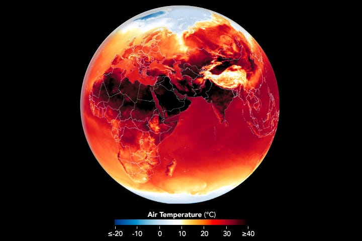
6. Global Heating
Over the past month, temperatures soared around the world - everywhere from Central America to North America, from the Middle East to South Asia, and from Africa to Europe. The image below from NASA shows the daily maximum surface air temperature across three continents combining satellite data with weather model outputs.
“According to the World Health Organization, heat stress is the world’s leading cause of weather-related deaths and can exacerbate underlying illnesses including cardiovascular disease, diabetes, mental health conditions, and asthma. Researchers have calculated that roughly 489,000 heat-related deaths occur each year, with 45 percent of the deaths in Asia and 36 percent in Europe.”
A Curated List of EO Jobs
As a result of the recent layoffs in the EO and EO-related sectors, several folks are looking for jobs.
Below is a curated, non-exhaustive list of jobs shared with me over the past week. The list below does not contain every job shared, please refer directly to the LinkedIn post for more.
Based on the roles, I have categorised them into five categories: Software ((incl. Geospatial), Business, Remote Sensing, Engineering and Product. Feel free to add other roles in the comments here or on LinkedIn.
PS. I am not a recruiter, I have no interest in being one and I don’t get a commission for any of this - I am just sharing jobs that were shared with me. Please don’t send me CVs.
EnduroSat, Bulgaria - Software, Remote Sensing, Engineering
Spire, Various - Software, Business, Remote Sensing, Engineering
Airmo, Germany - Software, Remote Sensing, Engineering
OroraTech, Germany - Software, Engineering, Business
Terradue, Italy - Software, Business
SpaceKnow, Czechia - Software
Space Intelligence, UK - Remote Sensing
WeatherStream, USA - Software
Pachama, USA - Software, Remote Sensing
Element84, USA - Software
S[&]T, Netherlands - Software
Development Seed, Europe - Software
Deimos, UK - Software
Little Place Labs, USA - Remote Sensing
Sust Global, UK/USA - Remote Sensing
50+ jobs across domains posted on this LinkedIn thread
30+ data science jobs in this newsletter
30+ GIS jobs in this newsletter
Until next time,
Aravind