

Last Week in Earth Observation: June 24, 2024
Last Week in Earth Observation: June 24, 2024
Monitoring Marine Litter from Space, Planet's Integration of Edge Computing and Mapping the Ocean Floors

Welcome to a new edition of ‘Last Week in Earth Observation’, containing a summary of major developments in EO from the last week and some exclusive analysis and insights from TerraWatch.
Four Curated Things
Major developments in EO from the past week
1. Contractual Stuff: Funding, Contracts and Deals 💰
Funding
Japanese SAR data provider Synspective raised $44M in a Series C round for global business expansion;
South Korean geospatial intelligence startup Dabeeo has raised $6M in a Series B bridge round;
French startup vorteX-io raised €2.9M to build hydrological monitoring solutions leveraging satellite data;
EO-based infrastructure monitoring startup, Spottitt raised an $800K bridge financing round;
Contracts
NASA selected Raytheon to provide three instruments for the Landsat Next mission for a contract value of $506M;
NASA, on behalf of NOAA, awarded Lockheed Martin a contract worth $2.27B to build the satellites for the next-generation GeoXO constellation;
Planet is expanding its contract with the Government of New South Wales, Australia to support crisis response, urban planning and biodiversity management;
Edge computing firm Ubotica was awarded grant funding as part of a European project to demonstrate on-board processing capabilities;
M&A
French defence firm Safran has entered into exclusive discussions to acquire EO-based geospatial intelligence startup Preligens for €220M.
2. Strategic Stuff: Partnerships and Announcements 📈
Announcements
Planet announced that it will be integrating an Nvdia AI processor in one of its upcoming satellites (more on this below);
Partnerships
Thales, Spire and the European Satellite Services Provider announced a memorandum of cooperation to develop a satellite constellation with ADS-B sensors dedicated to air traffic surveillance;
EO analytics firm Ursa Space Systems announced a new partnership with Japanese firm NEC Corporation to provide SAR data insights in Japan;
Brazil and China sign agreement to jointly build the CBERS-5 satellite, aimed at acquiring meteorological data;
CBRE, a commercial real estate investment and services company is partnering with EO-based climate risk analytics firm Climate X to provide comprehensive climate risk data for property investors.
3. Interesting Stuff: More News 🗞️
The World Meteorological Organization announced that it will be implementing Global Greenhouse Gas Watch an initiative to build a global greenhouse gas monitoring system;
The EU officially launched its Destination Earth system, a high-resolution digital twin of the Earth system to help Europe to better respond to major natural disasters and adapt to climate change;
Canada announced its 2030 Nature Strategy, in which satellite data will play an integral part;
Zimbabwe will launch its second EO satellite, ZimSat-2, later this year;
EO firm Satellogic announced a new round of layoffs, affecting 70 employees and is also slowing the deployment of new satellites;
The European Centre for Medium-Range Weather Forecasts introduced a new AI-based ensemble weather forecasting system.
4. Click-Worthy Stuff: Check These Out 🔗
This study that found that global nitrous oxide emissions, which account for 6.4 percent of total greenhouse gas emissions, are increasing;
This article on monitoring highway embankments, roads, and airport runways from space using SAR data;
This announcement from the Seabed 2030 project on their successful increase in the mapping of the ocean floor, which is now at 26.1%.

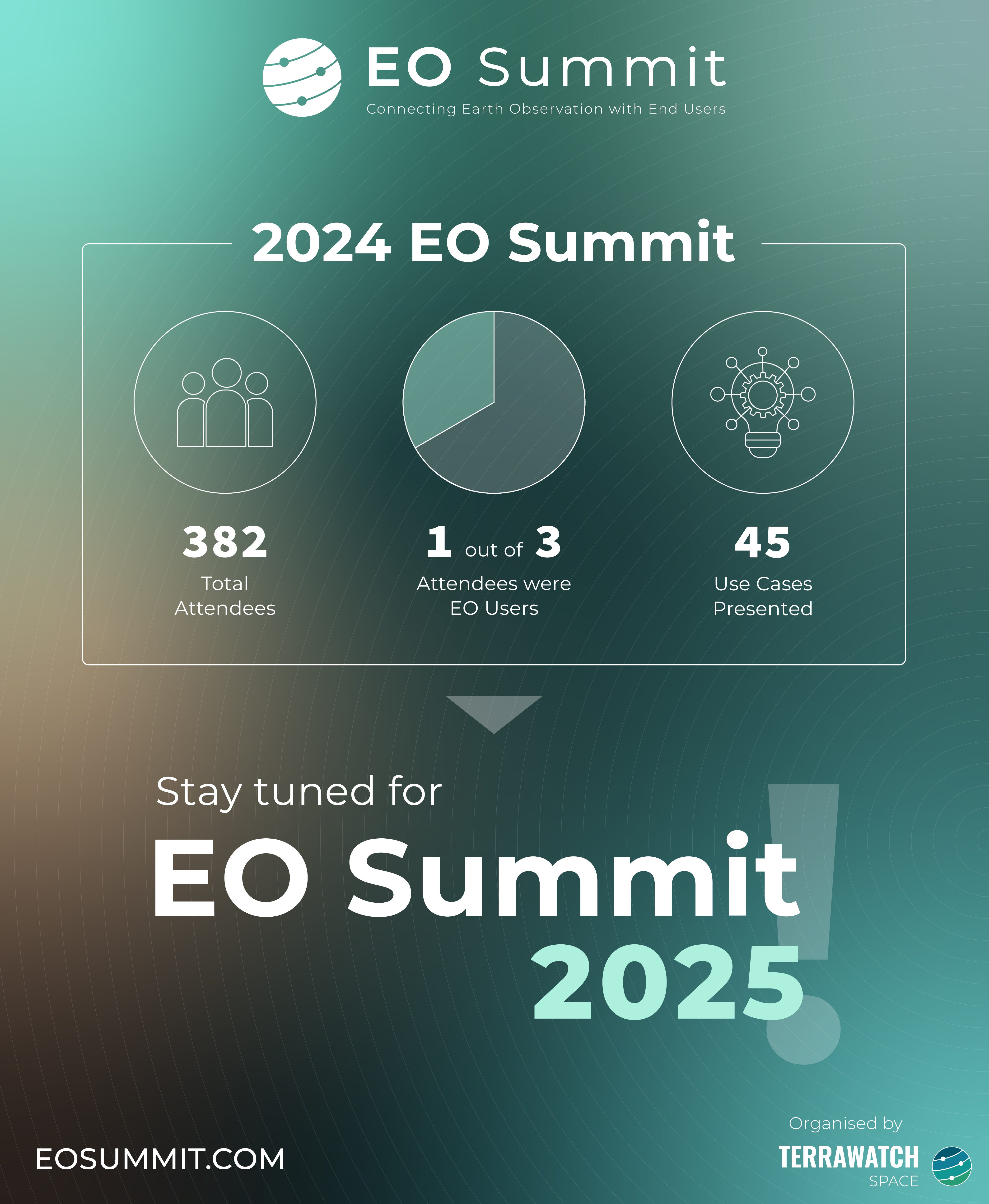
EO Summit: Thank You and Stay Tuned for 2025!
Just about 10 days ago, my 2-year dream of organising a user-driven, application-focused Earth observation conference became a reality. Our 3-member organising team, with no experience organising events, pulled off the impossible, with support from the hardworking volunteers on-site.
A big thank you to the generous sponsors, the amazing speakers, the thoughtful moderators and all the 375+ attendees who made the event a grand success.
EO Summit will be back, better and bigger in 2025. Stay tuned!
If you missed EO Summit, here is a good summary of the insighful keynote address from NASA Goddard’s Dalia Kirschbaum and a honest review of the event from an attendee.
One Discussion Point
Exclusive analysis and insights from TerraWatch
5. Planet’s Integration of Edge Computing
Planet announced recently that an upcoming test satellite - the very high-resolution image-capturing Pelican-2 will be equipped with a Nvidia Jetson edge AI graphics processing unit to “power intelligent imaging and faster insights for customers.” Honestly, this came as no surprise to me and was just a question of when not if. But, why do this and what does this mean for Planet?
First, what is Edge Computing?
Edge Computing means having the ability to process data closer to where it’s being generated, enabling processing at greater speeds and volumes, leading to greater action-led results in real-time.
It is not a new concept at all as we see edge computing in action almost every day - smart speakers, smart watches, smartphones, point of sales systems, wearable medical devices, smart power grids and even the recently announced Apple Intelligence.
Edge Computing in EO
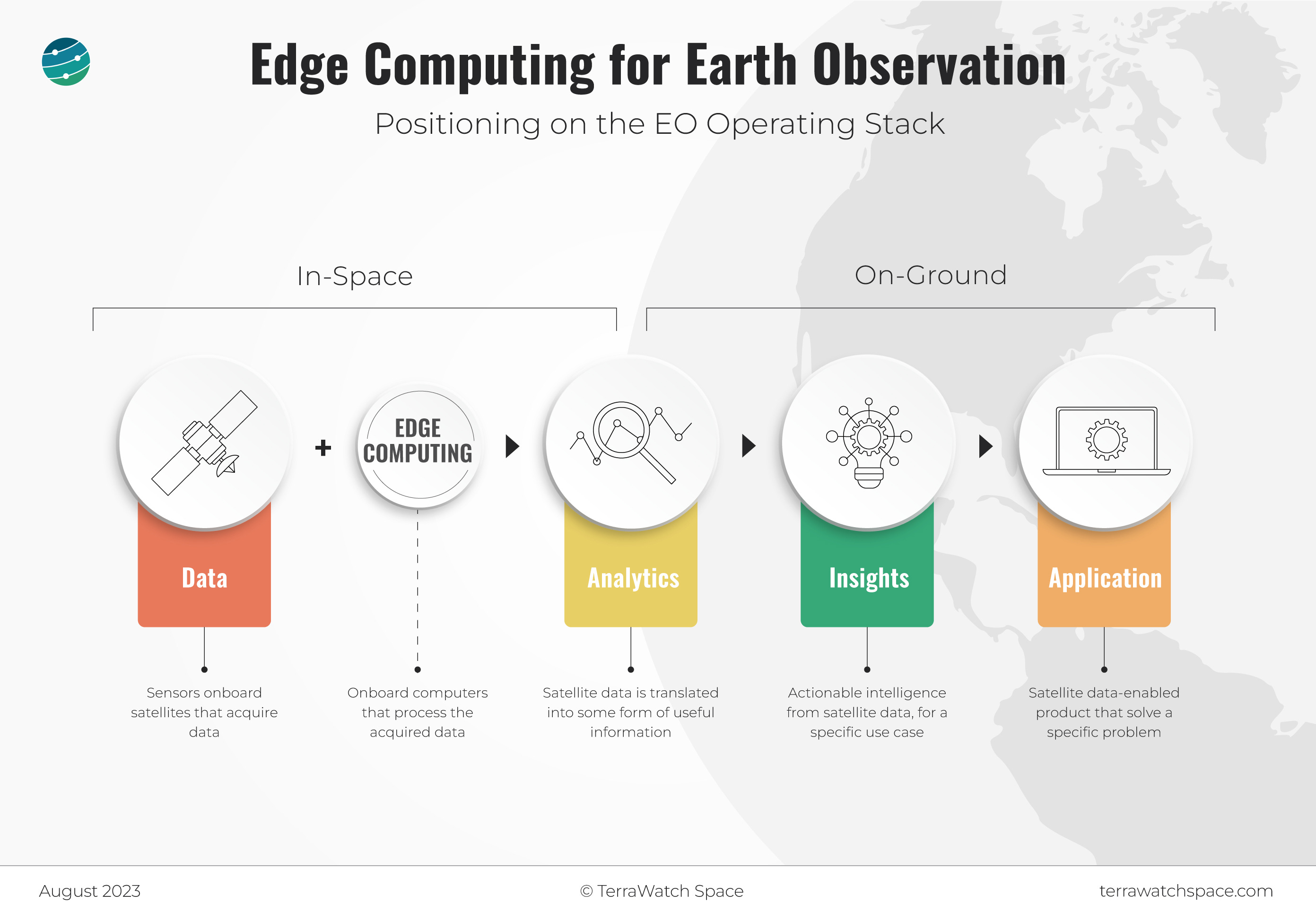
If you have read anything from TerraWatch before, you know that I segment the EO Operating Stack into 5 segments: Data, Platform, Analytics, Insights and Applications. Edge computing might have some interesting dynamics on the Platform layer, but its impact on the Analytics layer is perhaps more fascinating.
As a reminder, the Analytics layer is the part of the EO value chain, where data is converted into useful information, sometimes by integrating other sources of data. However, note that the Analytics layer does not inform, it only translates. You might not be able to make direct decisions with Analytics, as you might need to contextualise the information. Some examples of Analytics are cloud detection, vessel identification, building detection, crop classification etc. As you see, Analytics is all about converting imagery on pixels into some information, but it is not an actionable insight.
And that is what edge computing brings to the table - the ability to process data onboard the satellite, as it is being taken, to convert this data into some form of useful information. Note that edge computing might not necessarily provide actionable Insights, nor can it become a usable Application. My thesis is that edge computing helps move the Analytics layer closer to the orbit, but not completely away from the ground, as the figure represents below.
Edge Computing for Planet
Planet already operates in almost 4 out of 5 layers of the EO value chain: Data, Platform, Analytics and Insights. So, why integrate edge computing in their satellites?
What edge computing offers to Planet is the ability to shake things up a bit and move Analytics closer to orbit. Some Analytics that Planet offers like cloud detection, building detection and vessel detection can be “outsourced” to be performed on-orbit, meaning the information can be provided to its customers in near real-time. However, note that the more complex insights (such as the Planetary Variables) will have very limited relevance to edge computing and might actually be harder to execute with limited training data available onboard the satellite.
For more on edge computing and the current market landscape, check out the subscriber-exclusive, deep dive.
Scene from Space
One visual leveraging EO
6. Monitoring Marine Litter from Space
Apparently, every 60 seconds the equivalent of a lorry-load of plastic enters the global ocean. However, since the quantity of floating debris is usually not large enough, you are less likely to ‘see’ it from space, at least with the spatial resolution offered by open data like Sentinel.
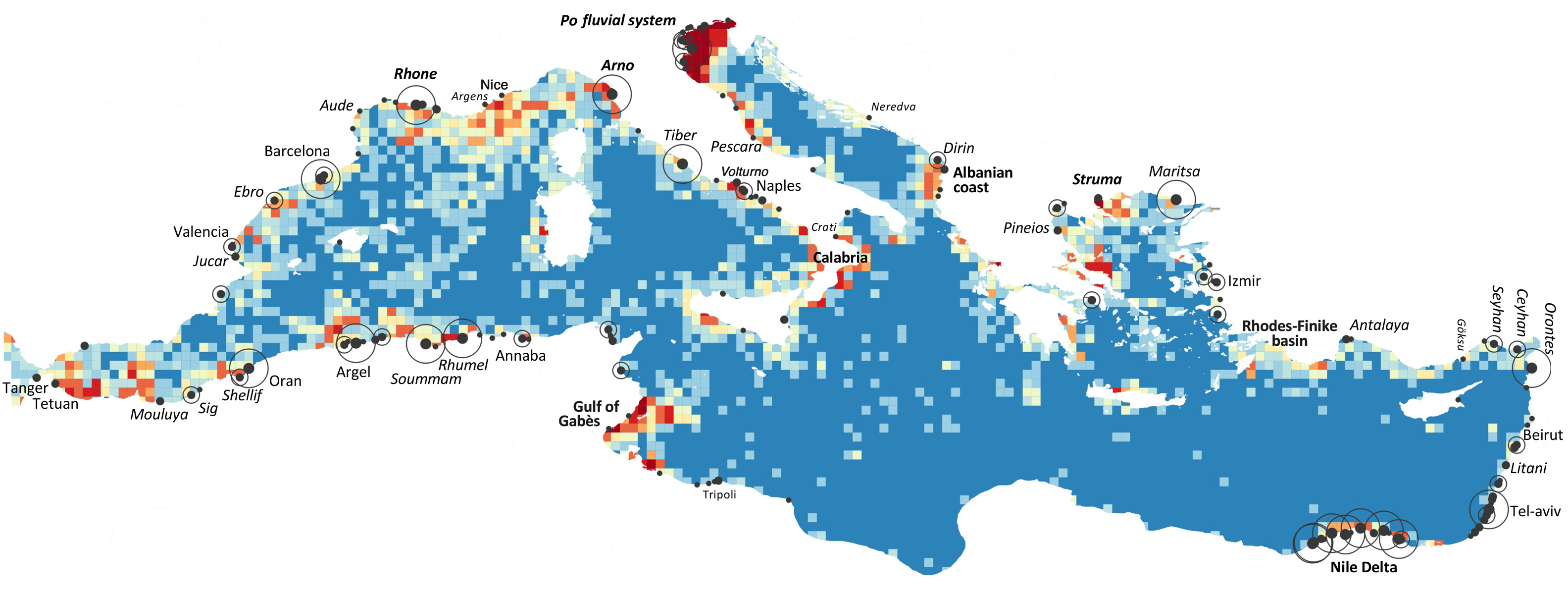
However, a team of researchers, funded by ESA, have created the most detailed map of marine litter pollution to date using data from Sentinel-2, spanning six years and over 300,000 satellite images while leveraging supercomputers and advanced search algorithms and validating with in-situ hydrological conditions. The team also highlighted the potential to develop a sensor to improve the accuracy of the monitoring. Who wants to build an EO satellite to detect marine pollution?
Until next time,
Aravind.