Context: Synthetic Aperture Radar
While many applications of satellite imagery are derived from the familiar electro-optical (or simply optical) instrument, Synthetic Aperture Radar, or SAR, is another remote sensing sensor that is capable of producing its own energy and then recording the amount of that energy reflected back after interacting with the Earth. It belongs to the category of active remote sensing sensors, having the ability to monitor through darkness, clouds, and rain.
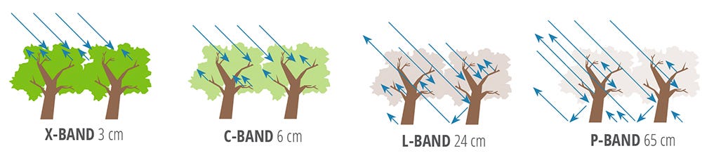
The different wavelengths that SAR instruments operate in are referred to as bands with letter designations such as X, C, L, and P, with average wavelengths shown in the figure below. Given the variety of wavelengths, each band has different applications: X-band SAR is typically used for high-resolution monitoring along with ice, snow, and ocean monitoring; C-band SAR is typically used for continuous global mapping and change detection; L-band SAR is typically used for ground surface monitoring; P-band SAR is typically used for vegetation mapping.
L-Band SAR
L-band SAR typically operates in wavelengths of 15–30 cm and is generally used for surface monitoring applications, such as ground infrastructure (pipelines, land deformation, etc.) and predictions of earthquakes and volcano eruptions, among others. Unlike the more prevalent X-band and C-band, L-band SAR can penetrate the soil to various depths, depending on soil conditions. Although L-band SAR does not produce images at a resolution that is as high as X-band and C-band, it works well in areas with thick vegetation—which means that it is an efficient solution for areas that are not easily accessible for monitoring or data gathering.
As of September 2023, there are only a handful of L-band SAR satellites currently operational in orbit. This includes SAOCOM satellites from CONAE, the Argentinian space agency, the ALOS-2 satellite from the Japanese space agency, JAXA and the Ludi Tance 4-01 satellite from the Chinese space agency, CNSA.
Looking ahead, at least two L-band SAR satellites are planned for launch: NISAR, a partnership between the US space agency NASA and the Indian space agency, ISRO which is expected to launch in 2024 as well as the ROSE-L mission, which is part of the next generation of the Copernicus programme, expected to launch in 2028. Along with that, at least one private Earth observation company has announced plans for launching an L-band SAR mission - a Canadian company named Alpha Insights plans to launch a dual-band (X and L) SAR mission.
How ASTERRA Uses L-Band SAR Technology
ASTERRA (formerly Utilis) is an Israeli-headquartered startup that provides water utilities, government agencies, and infrastructure managers with intelligence and insights from beneath the surface of their largest asset installations. It uses SAR analytics, patented algorithms, and artificial intelligence to detect leaks, assess pipes, explore minerals, and locate soil moisture near major installations, including pipes, roads, railways, dams, levees, commercial properties, and mines.
ASTERRA uses L-band SAR data, which can penetrate the soil to various depths depending on soil conditions, to detect underground soil moisture. Compared to traditional methods for determining soil moisture, such as the Laboratory Method, which involves laboratory testing of collected soil samples or the Direct Field Test Method, which involves a probe attached to the meter inserted into the soil, using data collected from satellites is more scalable. Even though accurate, these methods do not allow for the assessment of a wide area, which is critical for commercial applications for monitoring infrastructure such as pipes, dams and mines.
The following section discusses how ASTERRA’s EarthWorks solution leverages soil moisture measurement from L-band SAR data that can be used for mine safety applications.
L-Band SAR for Mine Safety
Mine safety, which is a continual ongoing topic of discussion in the mining sector, is becoming increasingly important due to climate change. While structural weaknesses and open pits pose a danger to the people working in mines, global warming is making floods, landslides, and other geophysical threats more likely. In 2022, about half of the major mining accidents were either a result of structural risks to tailing dams or geophysical risks in the areas of operation, both of which can be monitored and potentially avoided.
The current methods of responding to such risks are typically reactive, relying on motion sensors or collecting data using drones to identify problems once they are visually detected. However, using SAR data from satellites, ASTERRA’s solutions examine a much wider area. Even with a single satellite pass, monitoring can be conducted over 3,500 sq km (1,359 sq miles), which is not really practical or even possible with field technicians and ground sensors. Satellite-based monitoring provides a scalable solution for mines to continuously scan for risks and put mitigation measures in place.
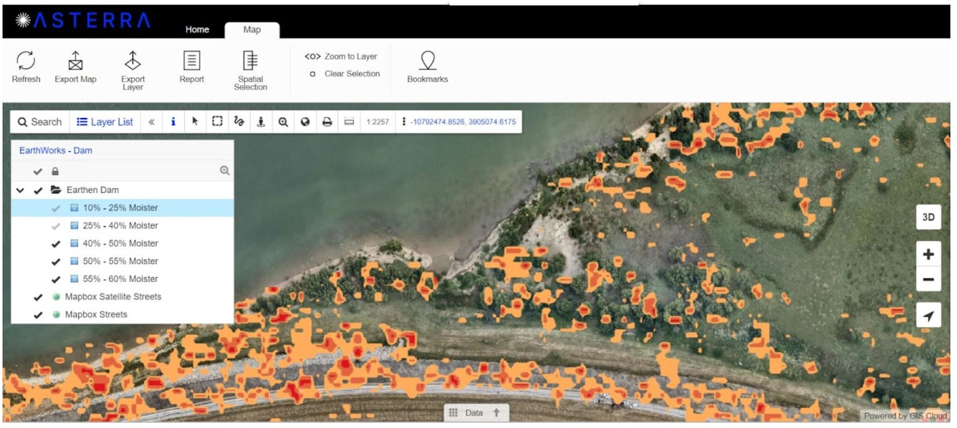
An example of the success of EarthWorks can be seen in ASTERRA’s work with a Northern European tailings dam. Based on a given area of interest chosen by the mine operator, EarthWorks leveraged L-Band SAR to produce sub-surface soil moisture maps for the selected area. Of that, about 2% of the area was identified as having high soil moisture which, when combined with topographical data from the area as well as data gathered from other ground sensors, provided critical insights regarding the structural integrity in the area. Thus, by continuously monitoring the soil moisture through SAR, the mining operators used this additional data layer in their infrastructure assessment tools, enabling them to improve their mine safety monitoring capabilities.
In addition to mine safety, ASTERRA’s has also pioneered the use of L-Band SAR for mine exploration applications, as discussed in the following case study of using SAR to pinpoint locations of lithium.
L-Band SAR for Mine Exploration
As the world transitions toward a clean energy economy, an influx of demand is expected for various minerals that would support this transition. As the "Critical Minerals Market Review" report from the International Energy Agency (IEA) notes, "demand for lithium tripled while nickel and cobalt demand increased by 40 and 70% respectively, between 2017 and 2022". Thus, the global energy transition is heavily dependent on the availability of several critical minerals.
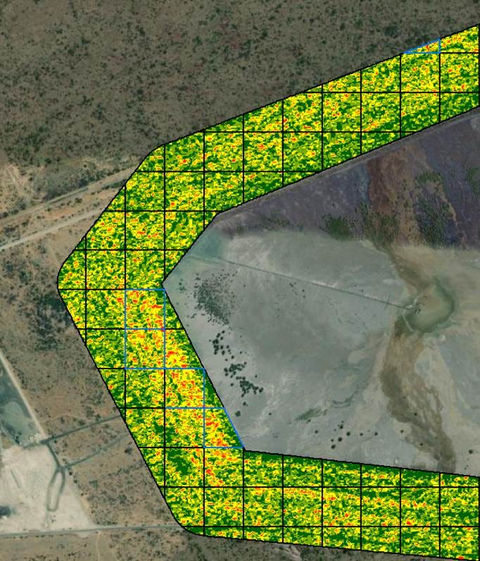
L-Band SAR data, with its ability to penetrate the ground, can be used to distinguish various physical properties of the surface, by measuring the type of scattering generated by the surface. Using a technique called polarimetry, the SAR data can be used to acquire different and complementary information about the same surface, through which critical minerals such as lithium can be identified from space.
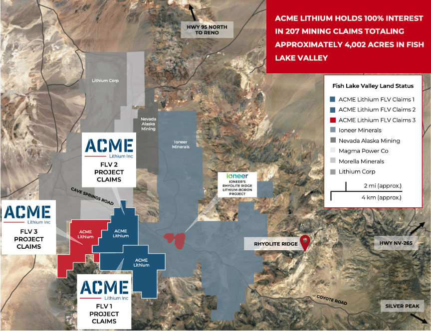
ASTERRA, with its proprietary algorithms and processing methods, was able to successfully discover lithium in Nevada. Through a collaboration with mineral exploration company, ACME Lithium, ASTERRA’s technology was able to discover approximately double the likely locations of lithium in the area than was identified using traditional methods of geochemistry exploration. As such, the SAR-based solution was able to pinpoint locations containing various grades of lithium, paving the way for ACME to increase the number of locations of lithium while also potentially reducing exploration time and costs. In addition, ASTERRA’s method does not involve any activity on the ground or the need to set up an infrastructure, which means that the technology does not contribute to any environmental impacts.
How ASTERRA’s Solutions Contribute to Sustainability Goals
ASTERRA uses data from space to protect limited natural resources and monitor community infrastructure on Earth. By providing subsurface ground saturation mapping at very high spatial resolution in three main markets: water utilities, wastewater, and ground infrastructure assessment, ASTERRA contributes to at least three of the seventeen Sustainable Development Goals from the United Nations (SDG 6, 9 and 13). In the examples presented above, the use cases of ASTERRA’s solution demonstrated how the company contributes to SDG 9 related to industry, innovation, and infrastructure.
Sponsored by ASTERRA