

Welcome to the new format of the TerraWatch newsletter. A few quick housekeeping notes before we get into the real content.
📢 Reminder: The TerraWatch Newsletter Is Evolving
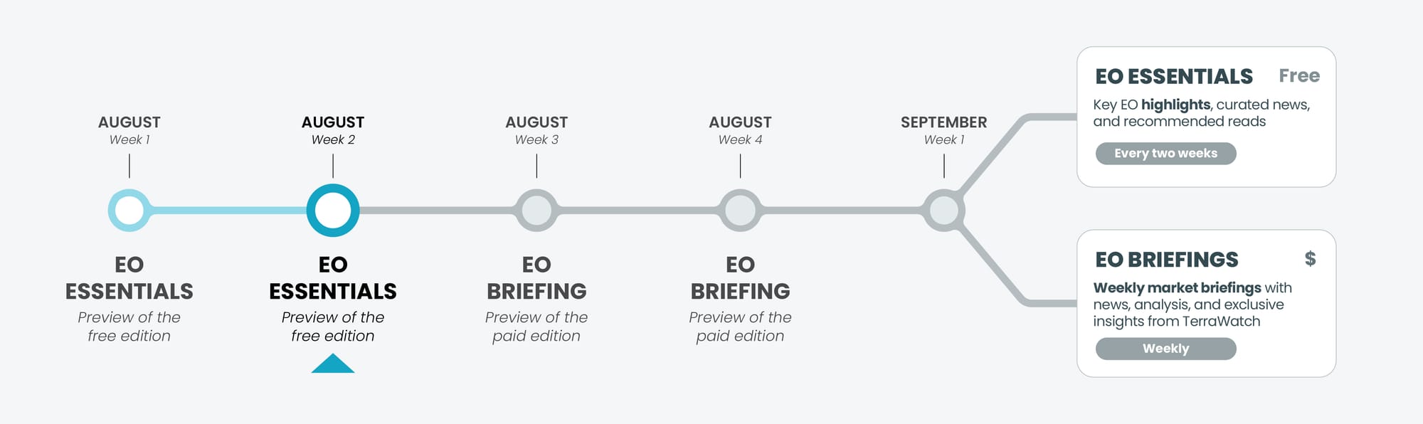
As announced, the TerraWatch newsletter is moving to a new model starting September 1.

To help you get familiar with what’s coming, this month you will be receiving previews of the new formats:
- This week, you are getting a preview of the the new Essentials edition that will go out every two weeks from September – shorter, sharper, and focused on key EO highlights, curated news, and recommended reads.
- The next two weeks August 18 and 25, you will receive a preview of the Pro editions for free, showcasing the weekly paid briefing with deeper analysis and exclusive insights (you can then decide if you want to upgrade).
📈 EO Market Highlights
Major developments in EO
🤝 ISS STOXX, a financial service firm that provides market indices and ESG data for institutional investors, has acquired Sust Global, a geospatial risk analytics firm, to expand its climate-risk modelling capabilities.
This is another example of backward vertical integration, where a key market player acquires an EO-based service provider (typically its supplier) to bring geospatial capabilities in-house.
🛰 Satellogic has expanded its partnership with HEO, a non-Earth imaging data provider, highlighting the growing trend of EO companies entering the space object monitoring market (Maxar and BlackSky being the other ones).
🏭 The US Administration is planning to shut down two NASA missions part of the - Orbiting Carbon Observatory series (OCO-2 and OCO-3) - aimed at measuring carbon dioxide and plant health.
💡 Insight Bytes
A quick dose of analysis from TerraWatch
Transparency and Trust in the EO-AI Era
We first created this graphic to capture something I felt was often missing in EO conversations. What we call “an insight” in the EO community is rarely just a single algorithm or a dataset. It is the result of multiple steps, each with its own assumptions, uncertainties, and human choices.
At the time, my aim was to show how many layers sit between raw satellite data and the final decision a user makes - from acquisition and processing to interpretation and delivery, with each stage have an impact on the final result.
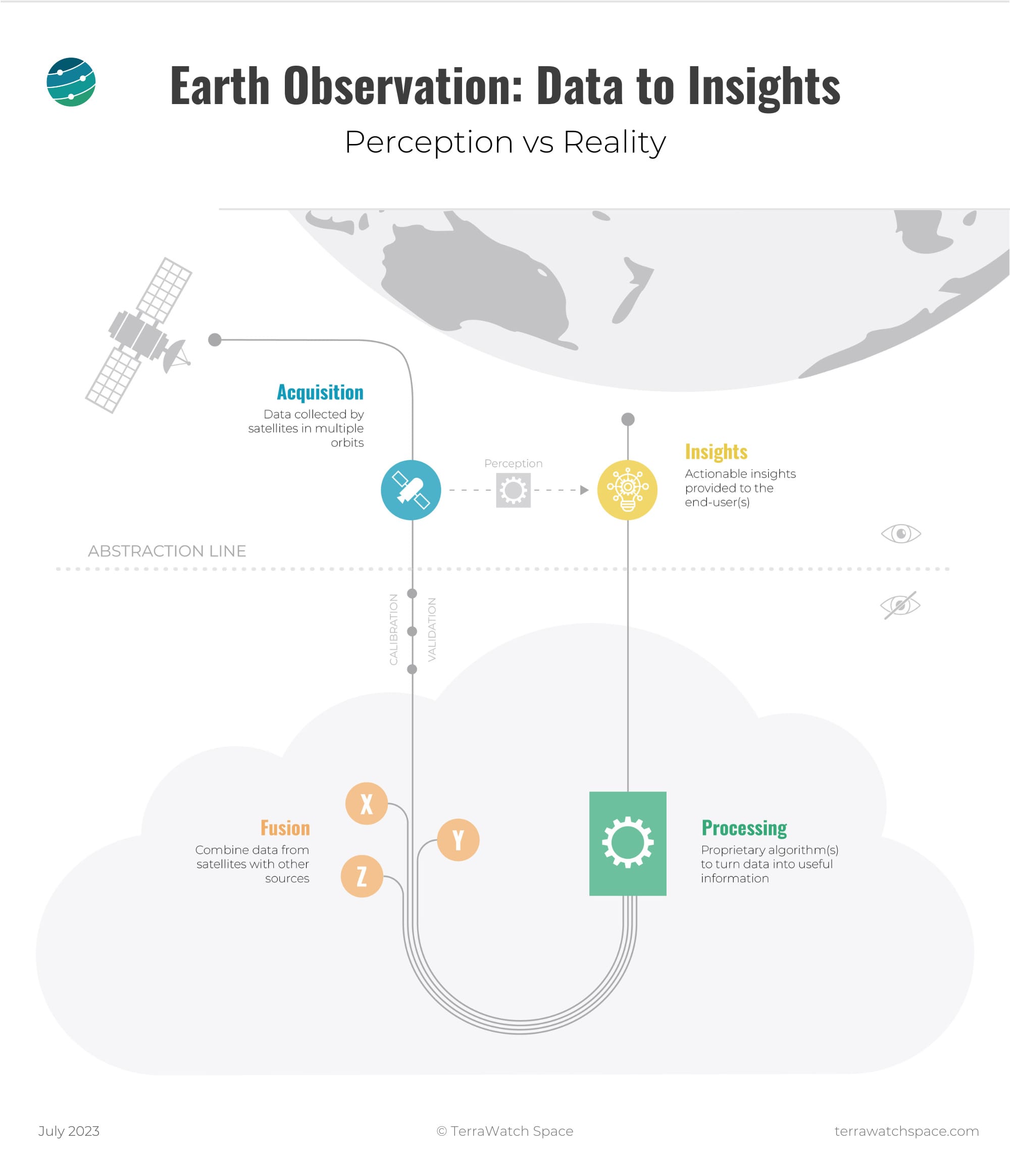
Now, in the era of embeddings and foundation models, this separation feels even more important. The more these steps are wrapped inside large, powerful models, the harder it becomes to understand what’s happening under the hood.
The risk is that speed and automation start to replace transparency and explainability. And in EO, where insights often drive real-world decisions in areas like disaster response, environmental monitoring, or infrastructure management, that’s not a trade-off we can afford.
For me, this graphic is a reminder that even with AI, every step in the EO chain matters. As we embrace new tools, we need to ensure we don’t lose the ability to interrogate how an answer was reached. The value of EO doesn’t just lie in the final insight, but in the trust we can place in every step that got us there.
Premium subscribers receive exclusive deep-dives such as EO for Climate Risk, EO for Carbon Monitoring, EO for GHG Monitoring and more.
Become a Premium subscriber to receive the upcoming 2025 editions of The State of Weather from Space and The State of Earth Observation.
🔍 Recommended Reads
Interesting links to check out
- This article providing insights on how NASA Harvest used satellite and sensor data to map flood damage in Texas to support agricultural recovery efforts.
- This map from the UN Satellite Centre presents EO-based damage assessment for the Gaza Strip, critical for humanitarian response activities.
- This article shows how the SWOT satellite captured a tsunami wave in the Pacific just 70 minutes after a major earthquake, providing precise data on wave height, shape, and direction and improving tsunami forecast models.
🛰️ Scene from Space
One visual leveraging EO
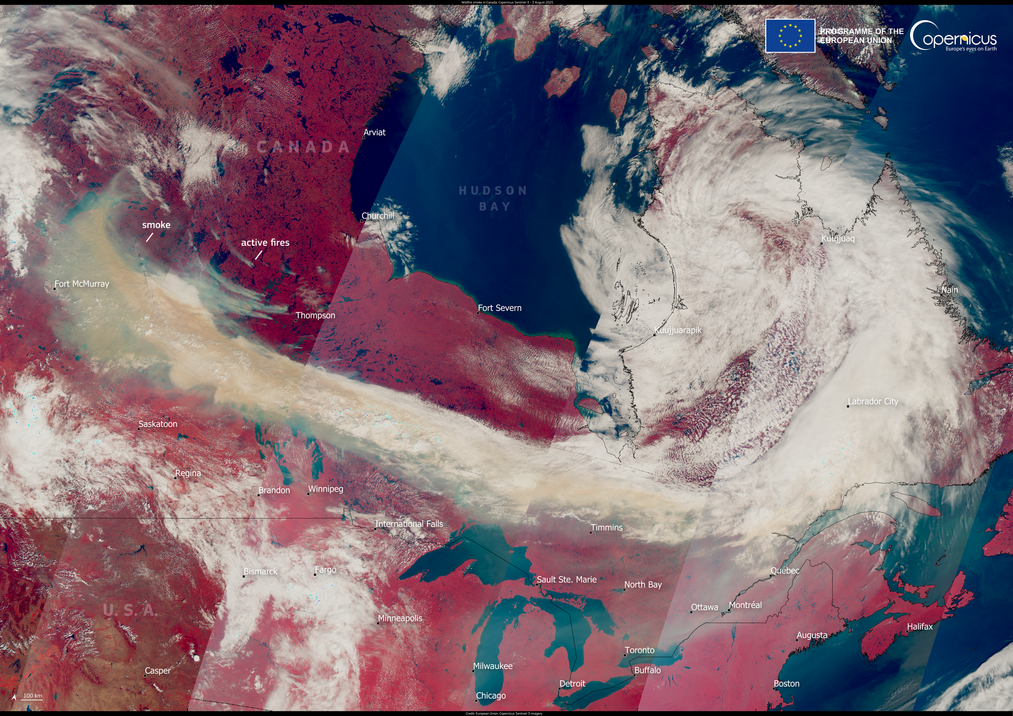
Wildfire Smoke Blankets Canada and the US
Canada is experiencing an intense wildfire season, with smoke plumes severely impacting air quality both domestically and across the United States. This false-colour image from Copernicus Sentinel-3, captured on 3 August 2025, shows a massive smoke cloud drifting over Canada and the US.
Until next time,
Aravind.


