

Welcome to another edition of Earth Observation Essentials, the free biweekly newsletter from TerraWatch covering key highlights from the EO market along with exclusive insights and analysis.
If you would like a more detailed, comprehensive market briefing with exclusive analysis, delivered every week, become a Pro subscriber, or a Premium subscriber, for more deep dives on EO markets, technologies and applications.
📈 EO Market Highlights
Major developments in EO
💰 German thermal data provider constellr closed a €37M in Series A funding round, to advance its system to “defence-grade status,” with sub-5-metre resolution, bringing the total funding raised to date to €75M.
💰 UK-based high-resolution thermal EO provider SatVu raised £30M ($40M) in a new funding round that included the NATO Innovation Fund, coming a week after the US National Reconnaissance Office added the company to its list of vendors.
The pivot to defense by EO companies is not a surprising trend, but it is proof of my essay Defense Paradox - playing out in real time.
🤝 Vantor and Google have signed an agreement to integrate Google Earth AI imagery models into Vantor's Tensorglobe platform improving the offering to sovereign governments operating in sensitive and classified environments.
The strategic question: does "Earth AI inside" become a feature or a product? I think that the EO companies that win won't have the best models, they will have the best productised outputs.
🤝 Planet announced a strategic partnership with AXA's risk management system, to provide high-frequency satellite imagery to monitor, predict, and respond to natural disasters in near-real-time. This follows AXA's partnership with Iceye recently, signalling a scaled-up use of EO by the insurance giant.
In the Pro newsletter, we covered Comparison of EO Satellite Company Funding by Sensor and Edge AI vs Optical Downlinks.
Become a Pro subscriber today for exclusive insights!
💡 Insight Bytes
A quick dose of analysis from TerraWatch
Foundation Models and EO: What Actually Matters
Geospatial foundation models (GFMs) are proliferating – Google has released Earth AI, open-weight alternatives are emerging, and nearly every EO platform already claims AI-powered analysis as a core capability.
This changes the strategic calculus for EO companies. The model itself isn't a moat, it is increasingly available, licensable, or buildable. What matters is what we do with it. I see two dynamics are playing out.
The Model Builders
First, GFMs need distribution. Whether it is Google, a startup, or an open-weight model out of a research lab, models don't reach customers. They need imagery archives to train and fine-tune on, and they need access to buyers.
EO companies with proprietary archives and customer relationships become the distribution layer. Vantor's integration of Google Earth AI is one example: Google gets its models embedded into workflows it couldn't reach directly and Vantor gets AI capability without building it in-house.
The EO Companies
Second, EO companies risk becoming data suppliers with a feature attached. If the offering is "AI-enabled platform," that commoditises as models proliferate, and the value shifts to whoever controls the last-mile solution application.
This is the trap: you integrate a foundation model, announce AI capabilities, and assume you have moved up the value chain. But if customers are buying your imagery and running someone else's model on it - or running your model but building their own applications on top - you are still a data company (low margins). In short, AI is a feature, not a product.
The Product Stickiness Factor
I believe that the path to margin in AI-based EO solutions is productisation. The EO companies that build durable businesses will not be simply selling an AI-based platform. They will be selling specific outputs: change detection reports, damage assessments, infrastructure monitoring feeds etc. – or, in other words, things customers can write into contracts and hold them to.
As models commoditise, the moat shifts to product stickiness: outputs that are integrated into the systems where decisions happen and renewed because they are operationally reliable. That stickiness comes from the boring stuff: versioned outputs customers can audit, known error rates they can plan around, and workflows embedded deeply enough that switching means rebuilding.
The difference between offering AI tools and delivering AI-based outcomes is where the margin lives.
The two upcoming deep-dives are: Edge Computing and the Future of EO (Feb 27) and The State of AI and EO (March 27)
The Business of Earth Observation - A Course from TerraWatch
Last few seats remaining for our course: The Business of Earth Observation, starting next week (see below).
The online live-cohort based course is designed for anyone that wants to get a clear, practical understanding of the technical, commercial, and adoption sides of EO. It is made for (but not limited to) everyone that wants to learn about EO, how the ecosystem operates, and how it is applied in practice - more here!

Course Information for Cohort A (EU/MEA-friendly)
Dates: Thursdays in March (Mar 5, Mar 12, Mar 19, Mar 26)
Times: 2 pm — 4 pm CET
👉 To Registration → Cohort A (EU/MEA-friendly) → 1 seat remaining / maximum 25 per cohort
Course Information for Cohort B (Americas-friendly)
Dates: Tuesdays in March (Mar 3, Mar 10, Mar 17, Mar 24)
Times: 12 pm — 2 pm ET
👉 To Registration → Cohort B (Americas-friendly) → 10 seats remaining / maximum 25 per cohort
🔍 Recommended Reads
Interesting links to check out
- This piece that explains why methane emissions from wetlands are rising faster than those from industrial sources, leveraging data from satellites.
- This explainer from ESA on how EO provides new insights for climate science.
- This article that shows the potential impact of the upcoming end-of-life of NASA's Terra satellite for fire monitoring in Australia.
- The early images from EarthDaily's first satellite of their constellation.
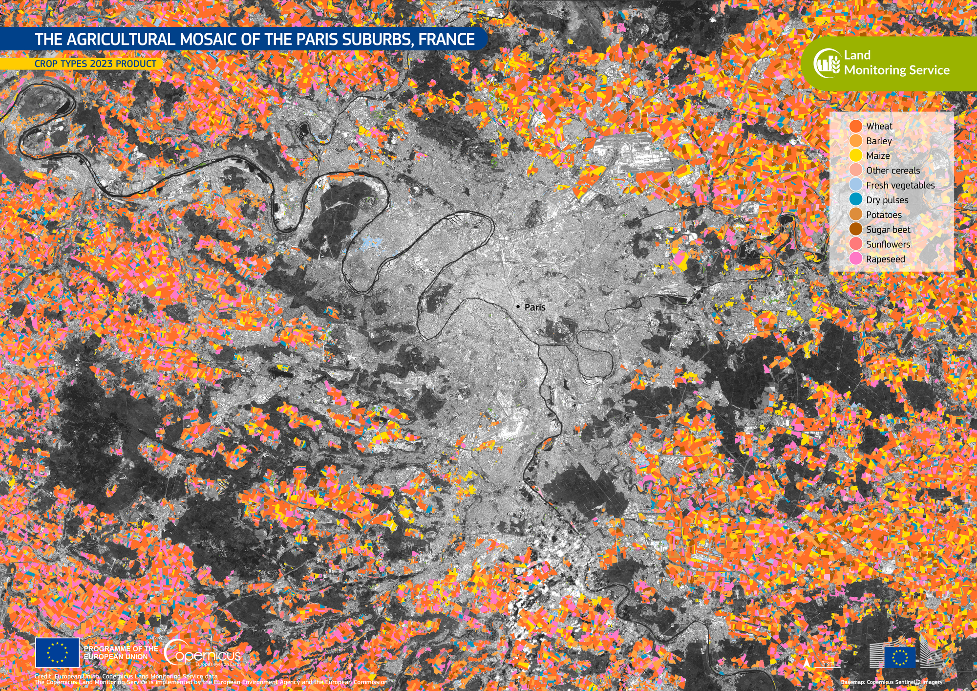
🛰️ Scene from Space
One visual leveraging EO
Crop Types Around Paris
The image below from Copernicus Land Monitoring Service shows the variety of crops in the suburbs of Paris including wheat, barley, maize, rapeseed and sugar beet among others.
Until next time,
Aravind.


