

Welcome to another edition of Earth Observation Essentials, the free biweekly newsletter from TerraWatch covering key highlights from the EO market along with insights and analysis.
If you would like a more detailed, comprehensive market briefing with exclusive analysis, delivered every week, become a Pro subscriber, or a Premium subscriber, for more deep dives on EO markets, technologies and applications.
📈 EO Market Highlights
Major developments in EO
💰 Weather intelligence firm Tomorrow.io raised $175M in late stage equity financing at a valuation of over $1B. The funds will be mainly used to fund DeepSky, its recently announced next-generation weather satellite constellation.
🛰️ German EO downstream solutions firm LiveEO announced that it will be launching its own satellite constellation, called Twinspector, capable of collecting 3D imagery to monitor critical infrastructure.
But, don't forget the sovereign angle, especially as Germany increases its space investment. Build it for enterprises, but price it for government is the quiet business model of most of the EO sector.
💰 NOAA is planning to dramatically increase commercial weather data purchases and is looking at a budget in the billions of dollars over 10 years and aims to publicly discuss the types of datasets the agency will need in the future.
🌊 The U.S. Navy is interested in commercial EO satellites that can acquire nighttime imagery, exclusively from electro-optical systems that have reached TRL, of 6 or higher.
🛰️ NASA has selected two Earth System Explorers Mission - STRIVE (daily, near-global atmospheric measurements) and EDGE (three-dimensional data on terrestrial ecosystem and glaciers, ice sheets, sea ice) - to be launched by 2030.
In the Pro newsletter, we covered the How NASA Handles Earth Science Data Continuity and the Why EO Analytics Companies Keep Building Their Own Satellites.
Upgrade to a Pro subscription to receive exclusive insights and analysis.
💡 Insight Bytes
A quick dose of analysis from TerraWatch
AI-Ready Data for Improving EO Adoption
We are producing more EO data than ever, but enterprise adoption hasn't kept pace. It's been said many times: the barrier is no longer satellite capacity, but the friction between raw pixels and operational decision-making. That is the gap I addressed in the white paper, published last year.
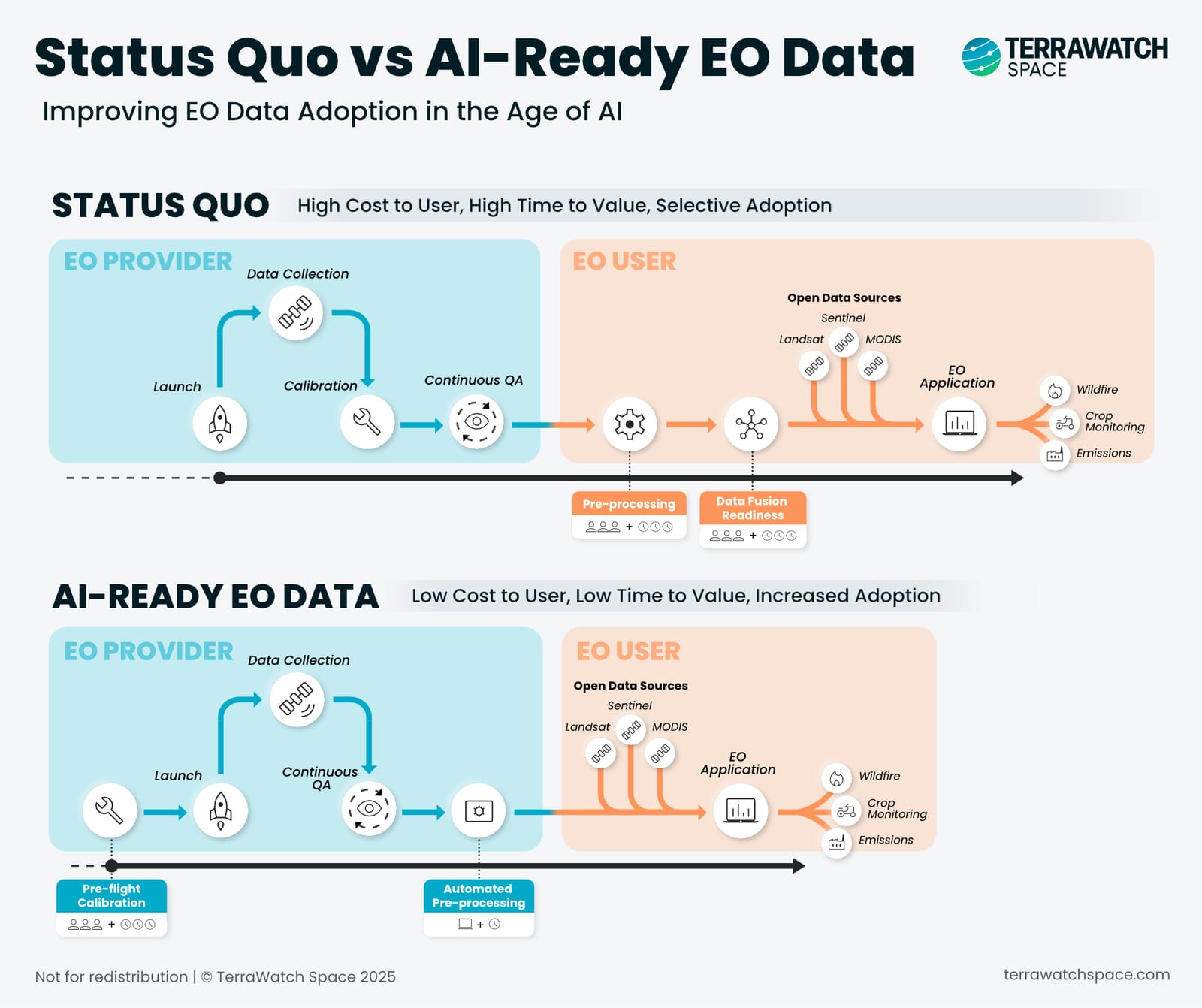
The Real Problem: Too Much Work Between Data and Value
Today, most EO data arrives in a state that still requires significant user-side work - cloud masking, geometric corrections, harmonisation across dates and sensors, and fusion-readiness - before it can be used in AI or operational systems. This forces every end-user organisation to rebuild the same processing pipeline from scratch.
EO is expensive not because of data cost, but because of the hidden integration cost. This is the single biggest reason EO stalls after pilots.
When providers handle calibration and automated pre-processing upstream, the user receives consistent, model-ready input. But AI-Ready is more than automated pre-processing—it means STAC-compliant metadata, Analysis Ready Data formats, consistent radiometric calibration, cloud-optimized delivery. Data that machines ingest without human intervention.
Foundation Models Raise the Bar for AI Readiness
Geospatial foundation models will not work with messy data, they require AI-Ready inputs by default. As these models become infrastructure for downstream applications, they define what data formats the market accepts. Providers whose data integrates seamlessly become default inputs. Those requiring custom preprocessing get excluded entirely – not outcompeted, just irrelevant.
Some argue foundation models will eventually handle inconsistent inputs—that embeddings and learned representations will abstract away format differences. But, I think models still need consistent training data to perform reliably, and preprocessing cost doesn't just disappear, it shifts to inference time. AI-Ready isn't made obsolete by foundation models, it is what makes them work.
The Open Data Issue for Commercial EO
AI-Ready EO enables something the industry has never had: true standardisation across providers and sensors. Multi-sensor fusion becomes plug-and-play, AI models become portable across geographies, and enterprises avoid vendor lock-in.
But here is the uncomfortable truth: Sentinel and Landsat are already closer to AI-Ready than most commercial offerings. Free, well-documented, and forming the backbone of most foundation models. Commercial providers charging premium for data requiring more effort than free alternatives face a hard question about their value proposition.
Does AI-Ready command higher prices or lower margins? Providers invest more upstream, but reduced friction typically compresses pricing. First movers may capture premium positioning as a differentiator. But as AI-Ready becomes table stakes, the rest compete on cost, against free.
Bottom Line
AI-Ready EO isn't about faster processing; it is about removing the structural friction that has limited adoption for a decade, and making EO compatible with how organisations actually operate in the age of AI. The providers who make this shift define the market, the rest might fade into irrelevance.
The Business of Earth Observation - A Course from TerraWatch
Registrations Open: Special Discount for Paid Subscribers
Registration is now open for our new course: The Business of Earth Observation, starting in March.
The online live-cohort based course is designed for anyone that wants to get a clear, practical understanding of the technical, commercial, and adoption sides of EO. It is made for (but not limited to) everyone that wants to learn about EO, how the ecosystem operates, and how it is applied in practice – more here!

Course Information for Cohort A (EU/MEA-friendly)
Dates: Thursdays in March (Mar 5, Mar 12, Mar 19, Mar 26)
Times: 2 pm — 4 pm CET (8-10 am EST)
👉 To Registration → Cohort A (EU/MEA-friendly) → less than 10 seats remaining / maximum 25 per cohort
Course Information for Cohort B (Americas-friendly)
Dates: Tuesdays in March (Mar 3, Mar 10, Mar 17, Mar 24)
Times: 12 pm — 2 pm EST (6-8 pm CET)
👉 To Registration → Cohort B (Americas-friendly) → less than 15 seats remaining / maximum 25 per cohort
🔍 Recommended Reads
Interesting links to check out
- This piece on an early U.S. signals-intelligence satellite program that pioneered geosynchronous collection and shaped modern intelligence capabilities.
- This thoughtful, grounded essay on how satellite data is helping transform food systems, mainly in the Global South.
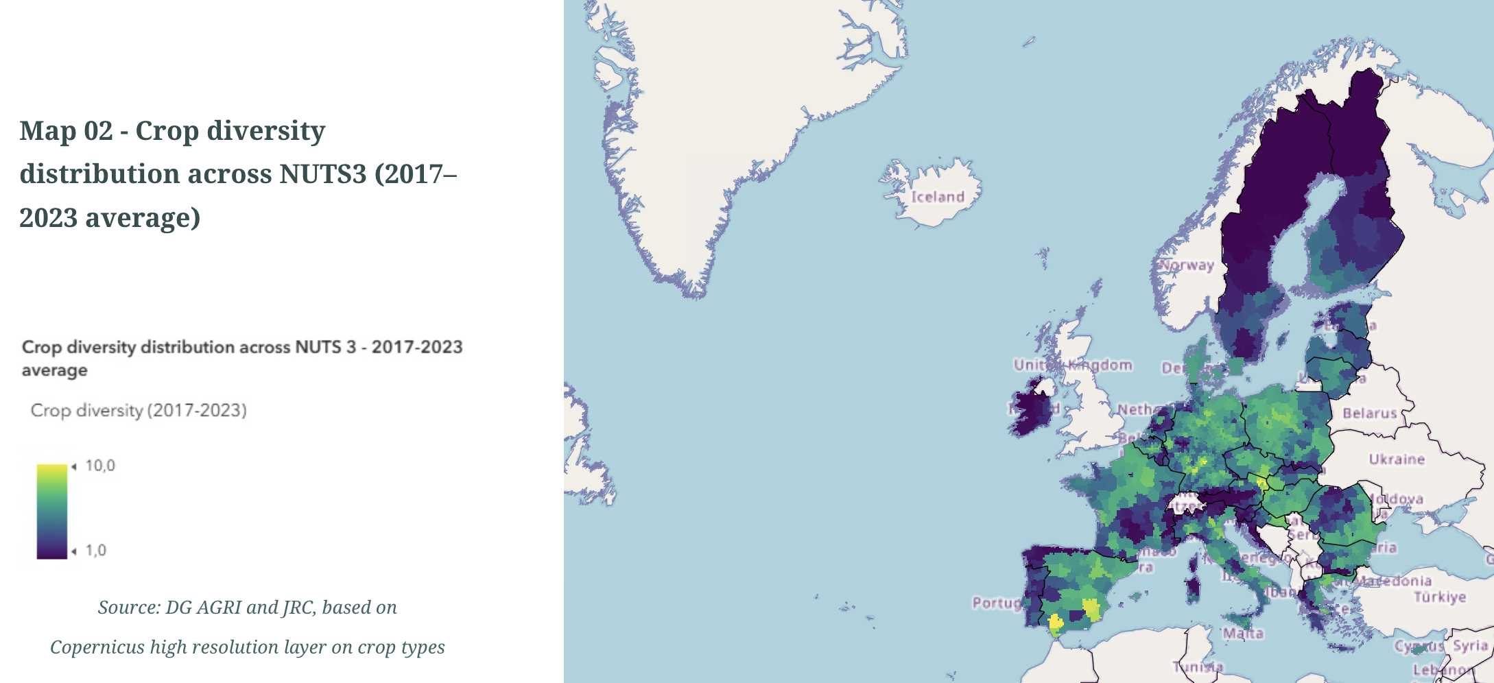
- This report on the diversity of crops in the EU derived from analysis of Copernicus data, along with the visual story map.
🛰️ Scene from Space
One visual leveraging EO
Measuring surface and cloud-top temperatures
The first images from the Meteosat Third Generation-Sounder satellite were recently published.
The infrared sounder instrument aboard the satellite uses a long-wave infrared channel to measure Earth’s surface temperature as well as the temperature at the top of clouds – a crucial input to weather forecasting models: indicate cloud height, type, and intensity while surface temperatures provide boundary conditions.
Dark red corresponds to high temperatures, mainly on the warmer land surfaces, while blue corresponds to lower temperatures, typically on the top of clouds.

Until next time,
Aravind.


