

Welcome to a new edition of Earth Observation Essentials, the free biweekly newsletter from TerraWatch covering key highlights from the EO market along with insights and analysis.
If you would like a more detailed, comprehensive market briefing with exclusive analysis, delivered every week, become a Pro subscriber, or a Premium subscriber, for more deep dives on EO markets, technologies and applications.
📈 EO Market Highlights
Major developments in EO
💰 ESA plans to request €750M for the EO component of the European Resilience from Space (ERS) initiative that will use a system of systems approach to bring together EO with navigation and telecommunications. This is the first time ESA is taking on a defense role with ERS supporting the EU's proposed Earth Observation Governmental Service mainly aimed at reconnaissance activities.
🛰️ Stratospheric monitoring firm Sceye won a NASA award for demonstrating an environmental sensor that can provide persistent monitoring over an area.
Satellites provide global coverage and long-term records, while stratospheric systems deliver persistent, localized intelligence - together forming a complementary architecture where satellites observe the planet broadly, and stratospheric assets fill the temporal and spatial gaps.
🏭 GHGSat signed a partnership with Petrobras, Brazil’s largest energy company, to monitor and mitigate methane emissions across Petrobras’ offshore and onshore operations in Brazil. This comes just a few weeks after a similar partnership with Exxon showing increase in uptake of emission data from the energy sector, prompting GHGSat to expand its constellation.
🌎 Planet will design, build and operate two prototype satellites for Google’s 'Project Suncatcher', a research effort exploring solar-powered orbital computing with an on-board AI accelerator and optical inter-satellite links. The mission, expected to launch by 2027, aims to demonstrate scalable space-based infrastructure for future data processing in orbit.
In the Pro newsletter, we covered an overview of EU-ESA sovereign EO constellations, what Google's Project Suncatcher means for EO and market size projections for the EO market.
Upgrade to a Pro subscription today for more exclusive analysis and insights!
💡 Insight Bytes
A quick dose of analysis from TerraWatch
EO for Methane Monitoring: Moving Beyond Measurement
As COP30 begins, I expect that this year will feature the usual parade of improved satellite capabilities and upcoming sensors. But the GHG monitoring challenge is not about seeing emissions anymore, it is about what happens after detection.
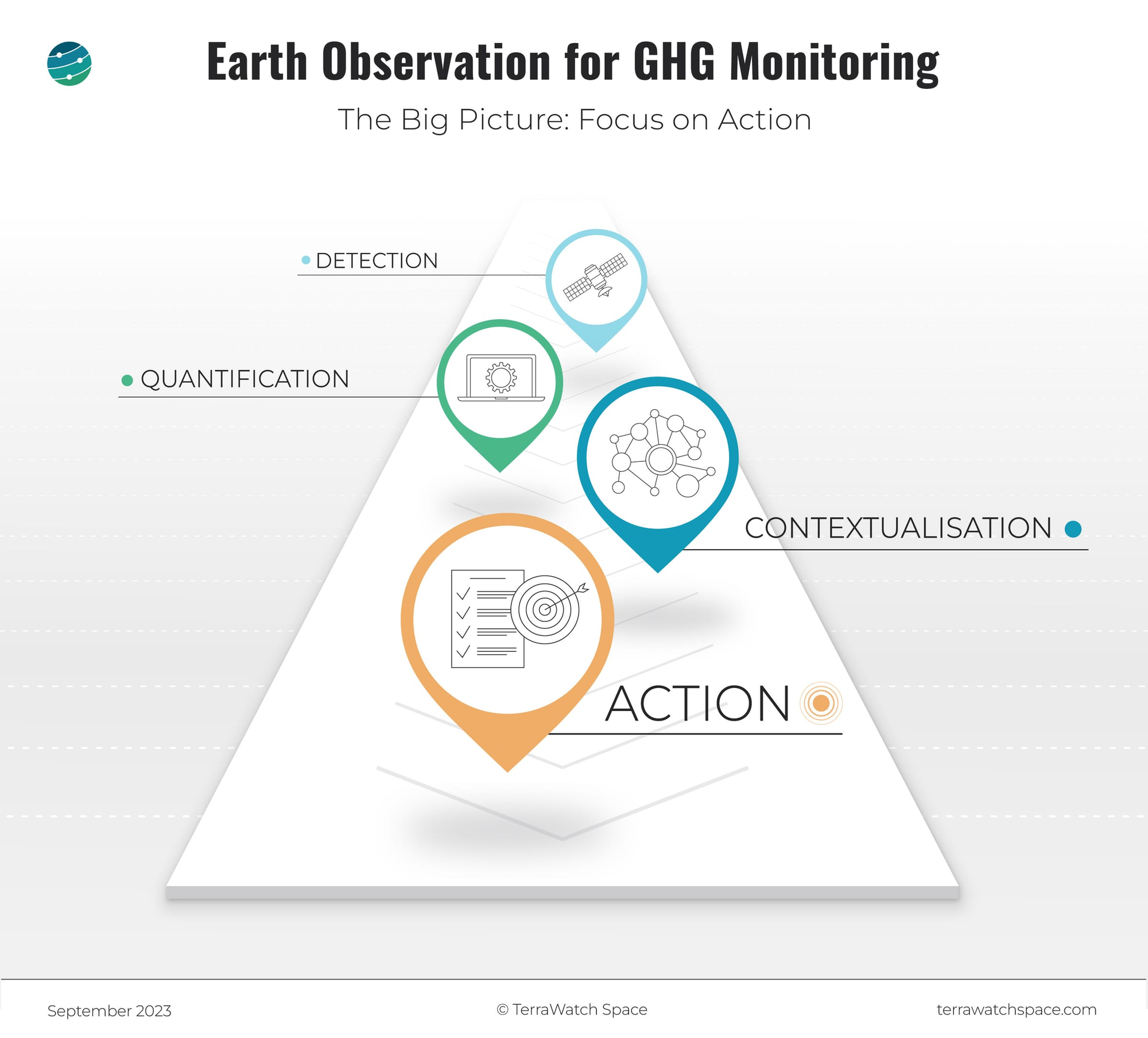
Quantification determines whether an observation becomes defensible data. Atmospheric modeling, algorithmic processing, and uncertainty quantification transform plume detections into emission rates that can withstand scrutiny. This is where measurement becomes evidence.
Contextualization connects emissions to accountability. Which facility? Which operator? Against what baseline? This layer integrates satellite observations with asset registries, ownership structures, and regulatory frameworks, turning atmospheric data into attributed responsibility.
Action is where the framework justifies itself. Regulatory mandates provide one pressure point, but economics matter equally - methane leaks represent direct revenue loss for energy firms, not just compliance risk. Yet intervention requires more than data delivery: it demands incentive alignment, operational capacity, and often technical training to enable fixes.
The hard truth: detection may be solved, but the rest isn't.
Upgrade to a Premium subscription and receive weekly market briefings on monthly deep dives on EO market, technologies and applications. The next planned deep dives are: The Invisibility Curve: A Framework for EO Adoption (Nov 20) and Edge Computing, Orbital Data Centers and the Future of EO (Dec 10).
🔍 Recommended Reads
Interesting links to check out
- This piece that discusses the threats of deepfake satellite images on social media and what satellite operators can do about it.
- This blog post from Ai2 on the recently released, fully open source, OlmoEarth EO foundational model.
- This paper demonstrating how very-high-resolution video imagery from satellites can measure river discharge with better than 5% accuracy.
- This article that dives deep into MethaneSAT's failure from the perspective of New Zealand, which made a $30M investment into the mission.
🛰️ Scene from Space
One visual leveraging EO
First Images from Feng Yun 3H Satellite
China released the first set of images from the recently launched Feng Yun (FY)-3H meteorological satellite. The satellite which has 9 instruments for multi-sensor atmospheric remote sensing, can simultaneous acquire data on variables such as temperature, humidity, clouds as well as greenhouse gases and auroras.
The image below shows a clear-sky composite image of Asia captured by the Medium Resolution Spectral Imager-III from October 9 to 21, 2025.

Until next time,
Aravind.


