


Context
If you have been tracking what's going in Earth observation and the wider geospatial sector, it is hard to avoid the buzzwords – foundation models, embeddings, agents, natural language search, LLMs etc. Many of these have moved very quickly from research papers/projects into product announcements/roadmaps.
The arrival of Artificial Intelligence in EO has created a slightly strange situation. Machine learning has been used in EO for a long time, so this is not a story about AI suddenly arriving and radically disrupting status quo entirely. What is new though is the scale of the ambition.
AI has fundamentally led people to move away from the idea that every new EO problem needs its own bespoke model, dataset and workflow, and towards a world where general purpose models trained across different types of data, problem sets and geographies can be reused and readapted for specific tasks.
If they work as promised, they could make satellite imagery easier to search, analyse and turn into intelligence, while reducing most of the specialist effort required to build new EO capabilities. Depending on whom you ask, it turns out you may not need a degree in remote sensing or spend tens or hundreds of thousands of dollars to take advantage of what EO can offer.
Like with any technology, the hype might be running ahead of the evidence in places, while the market is still working out where these models are genuinely useful and where existing approaches may remain better.
What all this means for the EO market is what fascinates me the most as AI could redraw where value sits in the industry. Given most of the current models are trained on open EO data, the moat may remain with those who hold proprietary data that the models cannot get elsewhere, and those who own the relationship with the end-users. Whether that happens, and which layer captures the value, is what this piece is all about.
Note: The entirety of this deep-dive is focused on EO Foundation Models (EOFMs) referring to those built around satellite imagery and other remote sensing data. AI weather models are outside the scope here – we analysed them in our most recent state of the weather market report.
Primer: EO Foundation Models and Embeddings
Before getting into the analysis, it might be useful to elaborate on a couple of concepts that we will be using throughout the piece, specifically EO Foundation Models and EO Embeddings.
What EO Foundation Models Are
An EO Foundation Model (EOFM) is pre-trained on large volumes of satellite data so that it learns general patterns that can be reused across different tasks. The important shift from traditional machine learning approaches where a model is typically built around one specific problem, and sometimes even one geography.
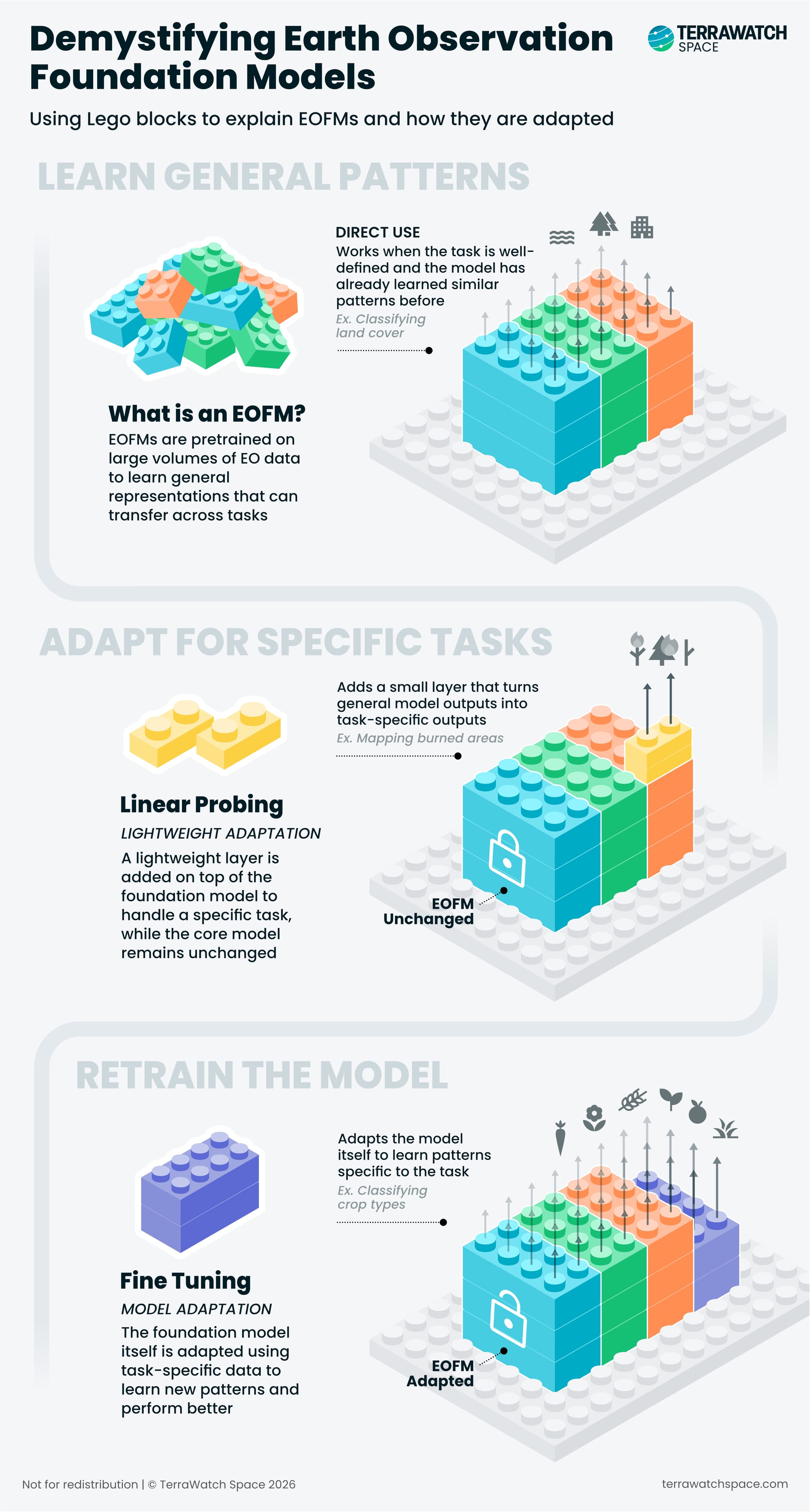
The visual above shows the different ways the knowledge learned during the training phase can be applied to a new task. Some tasks may need almost no adaptation, while others may require substantial fine-tuning and additional training data.
EOFMs are also not one homogeneous category – some are trained only on optical imagery, while others combine optical, SAR or other sensors. Some EOFMs are designed to capture how a place changes over time, while some also connect imagery with text, allowing you to go ask questions in natural language like "find all construction sites like this one."
Where Embeddings Fit In
EOFMs can turn satellite imagery into embeddings: numerical representations that capture the features and patterns the model learned from the data. Similar features tend to produce similar embeddings (codes), which makes them useful for search, comparison and downstream analysis.
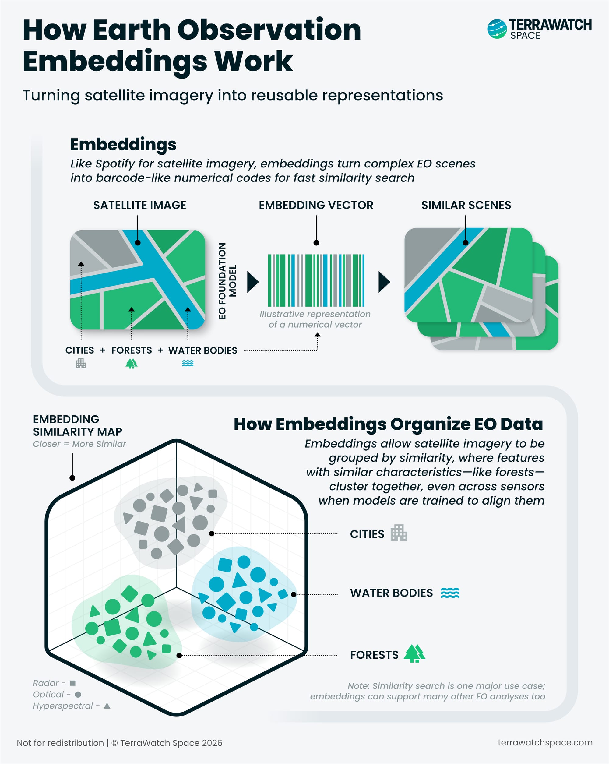
This also means the model itself does not necessarily have to reach the user. An organisation can run an EOFM once across a very large archive and distribute the resulting embeddings instead. This is what Google released with their big announcement of AlphaEarth Foundations embeddings last year. The user gets access to the model’s representations of the imagery without needing to run, host or even access the underlying model.
What makes embeddings interesting is that they have now created a new potential abstraction layer in EO. Embeddings are products in their own right, rather than simply an intermediate output inside an AI pipeline.
It also creates an important dependency: embeddings are not neutral representations of the Earth. What they contain depends on the model that produced them, the data it was trained on and the patterns it was designed to preserve. In practice, this means embeddings produced by two different EOFMs likely cannot be compared or combined, unless by design.
Agents, the other buzzwords doing the rounds, sit on top of all this. They can use an EOFM or leverage existing embeddings, but they can also work with conventional models, GIS tools and imagery catalogues, and none of the above needs an agent to be useful. We will cover geospatial agents in a separate deep-dive in the coming months, but you can check out Planet's Agentic AI, in the meantime.
Once EOFMs and embeddings become reusable building blocks of EO, they start changing the economics of EO. Who builds the models, what data they have access to, what gets commercialised (and how), and overall, where the value and moats in EO are going to shift to. The rest of this Deep Dive looks at how EOFMs will reshape the EO market.
Here's what we have in store:
- The EO Foundation Model (EOFM) Stack
- What EOFMs Enable: Which Use Cases Are A Good Fit for EOFMs?
- How EOFMs Change The EO Value Chain
- The EOFM Landscape: Model Developers vs Platforms vs Intelligence
- How EOFMs Impact The EO Market
- What Comes Next for EOFMs


