

Welcome to a new edition of ‘Last Week in Earth Observation’, containing a summary of major developments in EO from the last week and some exclusive analysis and insights from TerraWatch.
Four Curated Things
Major developments in EO from the past week
1. Contractual Stuff: Funding, Contracts and Deals 💰
Contracts
- German EO services firm GAF was awarded a multi-year contract by the Bavarian state in Germany for monitoring agricultural areas in the region;
2. Strategic Stuff: Partnerships and Announcements 📈
Announcements
- EO-based infrastructure monitoring solution provider ASTERRA launched what it claims to be the first ever API for commercial L-band SAR analytics;
- EOMAP, a German EO services firm specialising in marine monitoring has launched a new solution for monitoring water quality with satellite data;
- EO platform provider Descartes Labs announced the launch of Retina, a geo-intelligence platform for government agencies;
Partnerships
- SAR data and solution provider ICEYE announced a collaboration with Juniper Re, a recently formed reinsurance brokering firm;
- EO firms EarthDaily Analytics and OroraTech signed partnership agreements with CC35, an organisation of Latin American capital cities.
3. Interesting Stuff: More News 🗞️
- South Korea launched NEONSAT-1, the first satellite in a constellation of six aimed at improving surveillance and disaster management;
- NASA has ended the CloudSat mission that was launched in 2006 and provided the first global survey of cloud properties;
- Satellite images analysed by the Economist showed how Iran covered up the damage from Israel’s strikes.
4. Click-Worthy Stuff: Check These Out 🔗
This paper which includes a global geo-referenced dataset providing area information for 173 crops for the year 2020;
This report on the State of the Climate in Europe, published by the World Meteorological Organization;
This article from Meta that discusses the methodology behind the recently released open dataset of tree canopy height at a 1-meter resolution.
A balanced review of the data set and the methodology from Earth Blox.
EO Summit: Keynote Speaker Announcement
I am very excited to announce that Beth Greenaway, the Head of Earth Observations and Climate at the UK Space Agency will be joining us as a keynote speaker at EO Summit. Beth will discuss the power of EO for climate action and how the UKSA is leading the global efforts in EO.
💸 Tip: Save €100 and book your tickets for €299 now - extended until May 5!only until April 28! 💸

One Discussion Point
Exclusive analysis and insights from TerraWatch
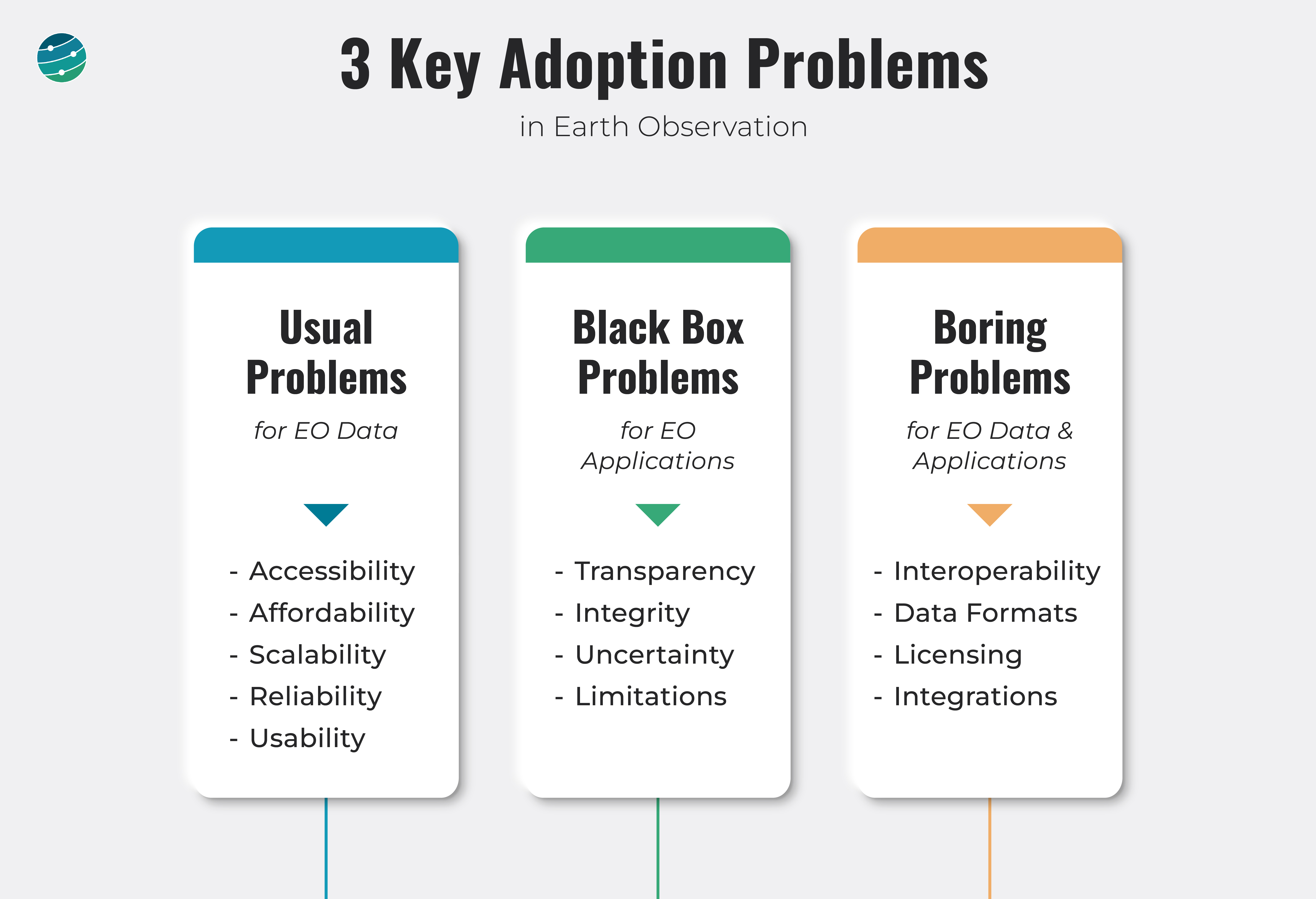
5. Adoption Problems in Earth Observation
This is a slide I presented in a recent keynote talk listing a few challenges in the adoption of EO across the commercial sector. They are categorised into three: Usual, Black Box and Boring.
Usual Problems include some of the most talked-about challenges in the EO sector and mostly involve EO data. The good news is that some of these are already in the process of being solved, thanks to the emergence of marketplaces and platforms that enable easier access, while newer EO satellite constellations are expected to make EO data more affordable and scalable. Reliability is still, a challenge, as not all captured data is actually available for commercial users. Usability and what that really means (aka analysis-ready data) is an ongoing discussion for which the theoretical and practical definitions may vary.
BlackBox Problems are mostly related to EO applications (products derived from EO) and their methodologies. As much as we focus on the role of EO in providing insights to solve a particular problem, it is equally, if not more, important to be able to fully understand how the insights were derived. Whether it is through continued peer-reviewed publications, complete transparency through an open-source model or simply letting the market decide, that remains to be seen. But, discussing uncertainties and limitations of what EO can and cannot do is an inevitable requirement to gain the trust of end-users.
Boring Problems are yes, really boring. Nobody wants to talk about them. Yet, unless we solve them, EO is less likely to go mainstream. Whether it is making EO data interoperable or standardising data formats, a lot has to be figured out. Licensing is another challenge that applies to both EO data and EO applications. Whether an EO application seamlessly integrates with existing enterprise software and how that integration is managed is yet another boring problem, which can hinder the procurement of an EO product in a large organisation.
Bottom line: It is not all about designing the sensors and launching the satellites - in fact, that might really just be the easy part.
If this was forwarded, subscribe for free to get your copy every week. Already a free subscriber? Then, become a paid subscriber and get exclusive EO insights.
Scene from Space
One visual leveraging EO
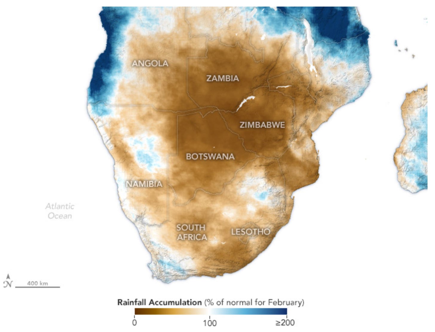
6. Estimating Precipitation from Space
Southern Africa received half or less than half of their typical rainfall in early 2024, leading to food security concerns for the millions of people living in Zambia, Zimbabwe, Angola, Botswana and South Africa. The map below shows the amount of rainfall in February, as a percentage of rainfall received each year between 1980 and 2024.
Since the African continent has the lowest number of in-situ weather stations and rain gauges, satellite data plays a major role in producing rainfall maps. CHIRPS is an initiative from the USAID, NASA, and NOAA that combines satellite imagery with in-situ data to create reliable, up-to-date climate data sets.
Until next time,
Aravind


