Welcome to a new edition of ‘Last Week in Earth Observation’, containing a summary of major developments in EO from the last week and some exclusive analysis and insights from TerraWatch.
Four Curated Things
Major developments in EO from the past week
💰 Contractual Stuff: Funding, Contracts and Deals
Funding
- Hyperspectral imaging firm Pixxel raised $24M in additional funding, taking its total Series B raise to $60M;
- Satellogic announced a $10M fundraise in private placement from a single institutional investor;
Contracts
- German thermal infrared data provider Constellr won a multi-year data contract from the German Space Agency (DLR);
- Satellogic announced an expansion of its contract with SynMax, a US-based energy analytics firm;
Earnings
- Planet reported $61.3M in revenues for Q3 2024, a 11% increase compared to the same period last year;
M&A
- Vaisala, a vertically integrated weather intelligence firm is acquiring the WeatherDesk business from Maxar for $70M.
This should come as no surprise as the private equity owned Maxar is in the process of divesting assets that are not core to its business and focusing on growth. Around the same time last year, Maxar sold its radio frequency monitoring division to Hawkeye 360.
📈 Strategic Stuff: Partnerships and Announcements
Partnerships
- EO firms Maxar and Satellogic announced a partnership that allows Maxar to exclusive rights to task Satellogic’s EO constellation, specifically to support national security missions;
- Hyperspectral imaging startup Esper is teaming up with space-as-a-service provider Loft Orbital, which will see its sensors fly on Loft's satellites in 2026.
Announcements
- UAE-based space firm Space42 and SAR-focused EO firm Iceye have announced a joint venture to bring satellite manufacturing to the country;
- Google announced an expansion of its Solar API expansion to the global south with reduced global revisit times.
🗞️ Interesting Stuff: More News
- China launched Haishao-1, a first-of-its-kind very low Earth orbit (350 kms), SAR satellite capable of integrated optical-SAR observations;
- NISAR, a SAR satellite built through an ISRO-NASA partnership is expected to launch in March 2025;
- Prominent tech investor Andreessen Horowitz included EO as one of their 'Big Ideas in Tech for 2025.'
- Long-term readers of this newsletter may find that the general theses on the future of EO (verticalization) put forward in the short snippet are quite similar to ideas you may have come across in my writings.
🔗 Click-Worthy Stuff: Check These Out
- This article that explores the use of natural language geocoding in geospatial applications, especially for change detection;
- This report from the US National Science and Technology Council presenting the 2024 National Plan for Civil Observations;
- This piece that summarises a paper presented recently on using declassified satellite images to understand the impacts of Vietnam War.
- By pinpointing bomb craters and swaths sprayed with herbicides, analysis could help direct remediation and cleanup efforts.

EO Summit 2025: Super Early Bird Ticket Sale - Extended
The Super Early Bird Ticket Sale for EO Summit 2025 has been extended until January 3, 2025. Hurry up and reserve your place at the only conference in 2025 with the highest number of commercial end-users discussing EO applications.
🎟️ Only ten more tickets are available at this price!
💰 Buy a full conference ticket for only $449 and save up to $300.

One Discussion Point
Exclusive analysis and insights from TerraWatch
5. The Need to Demystify the Process of Converting EO Data into Insights, in the Age of Artificial Intelligence
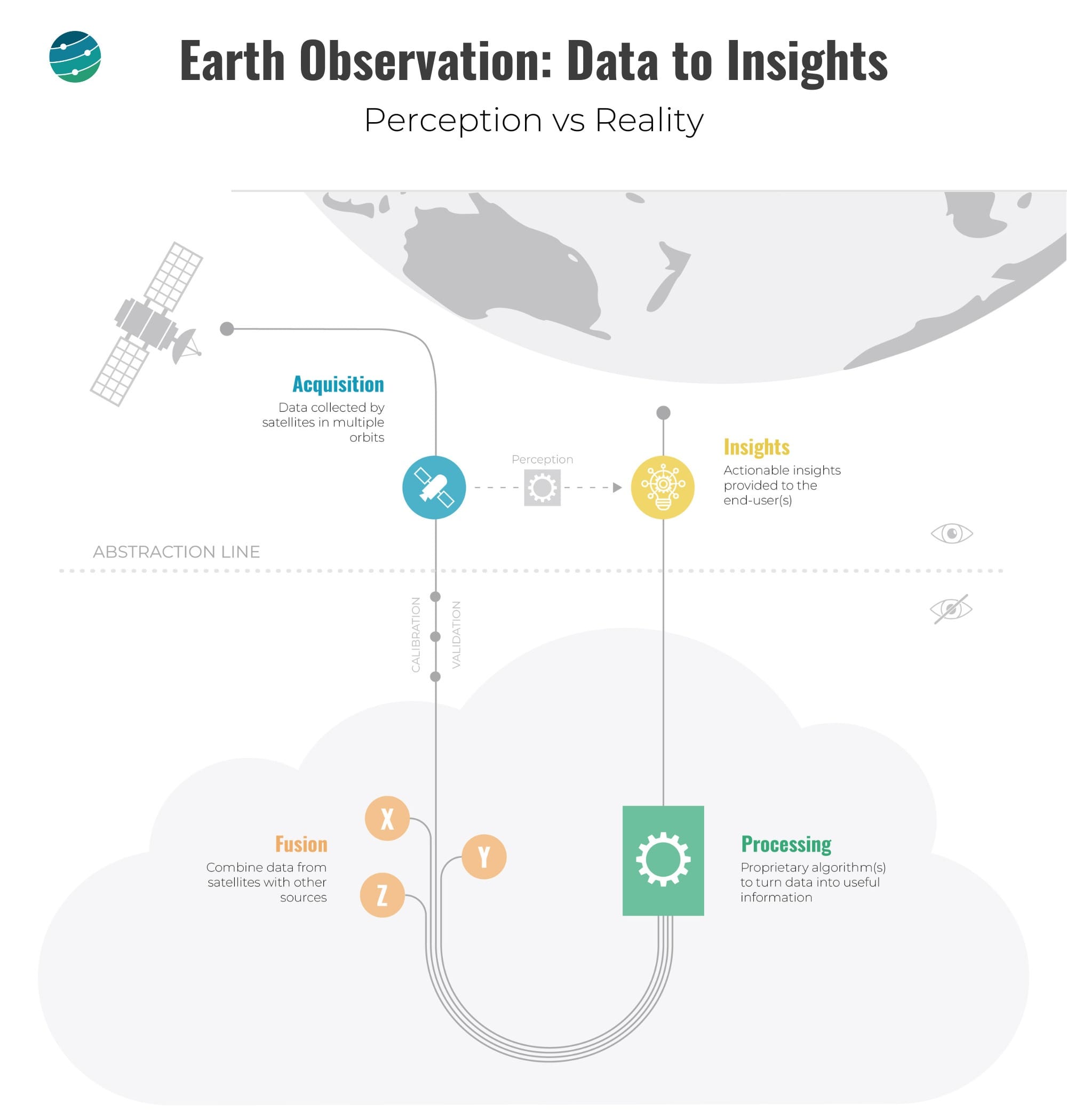
As EO enabled by AI continues to enable impactful societal, economic and environmental decisions, it becomes increasingly important to understand what goes on behind the hood - the tricks behind the magic of using satellites to derive insights. The figure below is an attempt to demystify the process of translating EO data into insight.
Some end-users of EO do not really care about how the insights are derived, but commercial EO-derived products are increasingly being used to make crucial decisions such as individuals deciding where to buy property, organisations identifying the climate risk for their assets, governments monitoring the level of wildfire threat for a region etc.
As the commercial EO industry continues to grow and increasingly plays a part in our lives, it might be a good time to start talking about the “black-box problem” in EO, especially as EO-based commercial applications become a fundamental part of the lives of individuals, businesses and governments. This is especially significant in the age of artificial intelligence.
AI agents are the new geospatial applications. In the era of AI agents, trustability and reliability - the ability to not be a black box - will become the competitive advantage. For many use cases, the overused statement "people don't want imagery, they want insights and don't care where they come from" will not be so valid anymore.
As much as we focus on the role of commercial EO in offering insights to solve a specific market problem, it is equally, if not more, important to be able to fully understand how the insights were derived. Whether it is through continued peer-reviewed publications, complete transparency through an open-source model or just simply letting the market decide, that remains to be seen.

This edition of the newsletter is brought to you by IGARSS 2025
Reminder: Submit Your Abstract or Paper by 10 January 2025 for the International Geoscience and Remote Sensing Symposium (IGARSS) 2025 taking place in Brisbane, Australia.
Explore a wide range of community contributed technical sessions and themes to find the topic you want to contribute to.
Scene from Space
One visual leveraging EO
First Images from Sentinel-1C
Less than a week after its launch, the Copernicus Sentinel-1C satellite has delivered its first radar images. The satellite is still in its commissioning phase, and will be operational in the coming months, which will reduce the revisit time of Sentinel-1 SAR images from roughly every 10 days to every 5 days - a game-changer for both commercial applications and environmental monitoring.

Until next time,
Aravind.


