Happy December! Welcome to a new edition of ‘Last Week in Earth Observation’, containing a summary of major developments in EO from the last week and some exclusive analysis and insights from TerraWatch.
Four Curated Things
Major developments in EO from the past week
💰 Contractual Stuff: Funding, Contracts and Deals
Funding
- Thermal infrared satellite startup SatVu raised £10M in new funding, ahead of two satellite launches in 2025;
- EO data processing platform Wherobots raised $21.5M in Series A funding;
- For more on the state of EO platforms, check out the deep-dive.
Contracts
- Telefix, a South Korean satellite firm, won a $10M contract from the government to build a weather satellite constellation equipped with infrared instruments (in Korean);
- Small satellite manufacturer Open Cosmos signed a contract worth $36.5M with ESA to build a trio of cubesats to study the Earth’s magnetic field;
- Australian EO satellite firm LatConnect 60 selected Spire to provide GNSS-R (reflectometry) data to provide soil moisture insights;
📈 Strategic Stuff: Partnerships and Announcements
Announcements
- Thales Alenia Space announced the Carb-Chaser project, a constellation of EO satellites to detect and measure CO2 funded by the French government;
- The UN's FAO (Food and Agriculture Organization) launched public dashboard solutions to support compliance with deforestation-related trade regulations;
Partnerships
- EO platform company Arlula signed a strategic partnership with NTT Data, a Japanese tech firm, enabling access to EO data for the Japanese Government;
- German EO startup Marble Imaging is teaming up with Danish satellite system supplier Rovsing to develop EO satellites and services;
🗞️ Interesting Stuff: More News
- China launched a pair of high-resolution SAR satellites for China Siwei Surveying and Mapping Technology, a state-owned firm that is building a 28-satellite remote sensing constellation;
- The Indonesian Space Agency said that outdated mapping data is a hurdle in disaster mitigation efforts in the country;
- SpaceX launched the fifth mission for the US National Reconnaissance Office's proliferated architecture, with an objective to have at least 100 satellites in what is called the "largest-ever, governmented-owned EO constellation";
The potential externalities (positive and negative) that the NRO's constellation has on the commercial EO sector will be interesting to watch. While there might be some losers in the short-term, I think it will be a net positive for the commercial EO sector, with some winners emerging in the long-term, to complement this constellation.
🔗 Click-Worthy Stuff: Check These Out
- This article demonstrating the knowledge-action gap with respect to the use of EO for climate: despite 1,200 notifications from the UN's Methane Alert and Response System over major GHG emissions, only 15 prompted responses;
Knowledge-action gap: If knowledge gathered from EO has not resulted in meaningful action, then the value of EO is not actually realised.
- This article that shows how satellite data was used to confirm that algal blooms were behind the sudden death of around 350 elephants in Botswana;
- This article that presents new research using a generative AI model to generate satellite imagery from the future to depict how a region would look after a potential flooding event (reinforced with a physics-based flood model).

One Discussion Point
Exclusive analysis and insights from TerraWatch
A Framework for Understanding EO Use Cases
When I advise EO startups, develop go-to-market strategies for EO companies, perform commercial due diligence studies for investors or assess the EO strategies for end-users, a set of questions always come up:
"Which EO use cases apply to my situation? What are the enabling technologies for those use cases? Which companies offer these solutions?
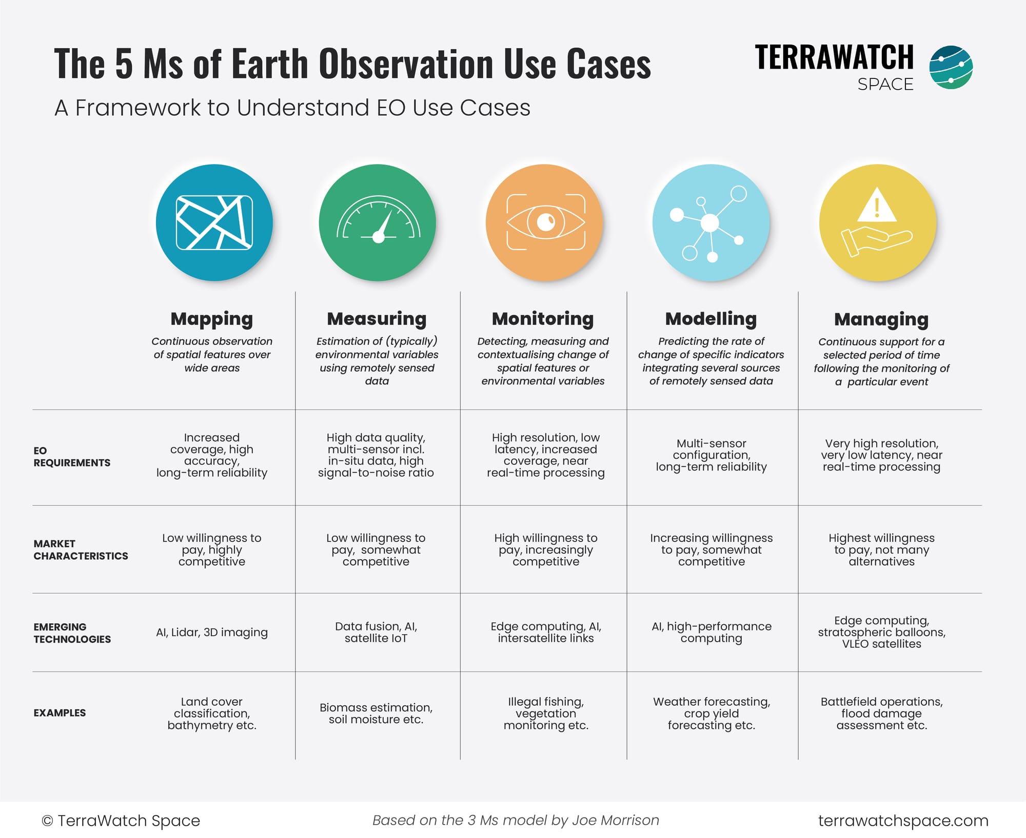
So, I wanted to develop a framework that categorises the different EO use cases into different themes, as a function of their technical requirements. Fortunately, my good friend Joe Morrison had already put in some thought into this and developed a 3M framework for classifying EO use cases. This model works well for the EO sector, especially for companies developing satellite constellations.
But, I wanted to create a EO use case classifying model that makes EO use cases easier to understand for those outside the EO bubble (investors, end users etc.), while also providing a structure for those within the EO sector while thinking about market positioning, product roadmap and go-to-market strategies.
So, the following figure is what I have ended up with (as a tribute to Joe, I stuck with the 'M' naming convention). The goal is to make EO use cases more approachable and create a starting point for discussions, especially in my consulting work. But, as I always do, I also wanted to share it with you.
Let me know if you have questions or any feedback!

Scene from Space
One visual leveraging EO
Towards a Greener Antarctica
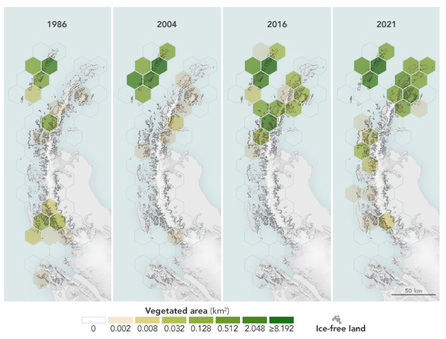
An analysis of 35 years of imagery from the Landsat satellites has found that the amount of vegetated land on the Antarctic Peninsula has increased more than tenfold since 1986 - 0.86 sq.km in 1986 to 11.95 sq.km in 2021. This evolution is mainly attributed to melting glaciers and warming temperatures as a result of which plant life is starting to thrive despite the cold climate.
The maps below show the amount of green on the peninsula’s ice-free land below 300 meters (1,000 feet) elevation at select years in the study period, based on NDVI analysis of Landsat data.

Until next time,
Aravind.


