

Hey! Welcome to a new edition of ‘Last Week in Earth Observation’, where I attempt to curate the major developments in EO from the week that just passed and provide some thoughts & analysis on some of them.
If you do not see something on the curated list and you think it is relevant, please send it my way. My aim is to make this weekly newsletter to be the most comprehensive resource there is, about all things EO.
Please subscribe for Earth observation insights!
Four Curated Things
A summary of some of the major developments in EO
1. Financial Stuff: Funding, Contracts and More 💰
- Maxar is on track to being acquired by Advent International, the private equity firm for $6.4B, after receiving no competing offers;
- Element84 has acquired Azavea, bringing together two organisations that quietly work together in the background to make geospatial data easier to process, analyse and visualise through open-source innovation;
- Peraton, a US-based defence contractor won a ~$400M contract from NOAA to provide ground services for polar-orbiting JPSS weather satellites;
- Orbital Insight, the EO platform company, reported that it has secured new global customers for its recently released Terrascope product, while also quietly announcing that it has raised a new round of undisclosed funding;
- Drone imaging firm, Zeitview (formerly DroneBase) raised $55M, positioning itself as complementary to and competing with satellite imagery.
2. Strategic Stuff: Announcements and Partnerships 📈
- Maxar is partnering with Umbra to receive dedicated access to SAR imagery, enabling Maxar to provide multi-source geospatial intelligence solutions for governmental and commercial customers;
- Maxar will also be teaming up with Heavy.ai, Bain, and NVIDIA to provide high-frequency, high-resolution digital twins for communication service providers enabling greater efficiencies in network deployments;
- UAE's largest satellite company, Yahsat and the country's space research centre, MBRSC, are partnering to build EO solutions for Yahsat’s customers;
- GHGSat is collaborating with the International Energy Agency to integrate facility-level emission data into Global Methane Tracker 2023;
- Space Compass, a Japanese joint venture between NTT and SKY Perfect JSAT, is partnering with Skyloom to provide optical data relay services for EO missions, aiming to reduce the data downlink latency to seconds;
3. Some Interesting Reads In The News 🗞️
- ESA launched the beta version of the Green Transition Information Factories platform aimed at providing tools for green transition derived from EO data;
- The WMO warned that the multi-year drought in the Horn of Africa will continue in 2023, which will take the region many years to fully recover.
- French AI/EO startup Preligens is aiming for success with the US DoD after winning contracts from the French defence ministry (in French);
4. Some Interesting Things To Check Out 🔗
- This piece on tracking water in Middle East and North Africa from space;
- An overview of stratospheric sensing, weather balloons and challenges;
- This Esri collection presenting the use of geospatial for all the UN SDGs;
- This case study from ESA showing how the Italian road agency uses EO (specifically SAR from Sentinel-1) to monitor and maintain roads;
- This technical deep-dive from Metaspectral on measuring ground-level carbon using hyperspectral imagery.
One Pre-Announcement
Something I have been working on
5. A Course to Demystify Satellite-based Earth Observation and its Applications for Everyone
I am putting together an EO course, aimed at outsiders, to provide them with a fundamental understanding of the technical, commercial and policy-related context of EO. More details about this live, cohort-based course including timeline, pricing and model to come shortly. And, in case you are wondering, here’s why I am doing this: I am convinced that we need more outsiders working in Earth observation in order to take it to the next level and make it mainstream.
My expected outcomes for the course are the following, but not limited to:
- For the EO enthusiasts to get enough technical and commercial context so that some of them end up transitioning into sales/marketing/product roles in the EO companies or end up starting one - in other words, to help them answer, “What can I do in the EO industry?”;
- For the new entrants, who have just joined EO companies to help them get onboarded within their respective organisations and get a bird’s eye view of the EO sector - in other words, to help them answer, “How can I learn just about enough to get started with my job in EO?”;
- For the end-users of EO data/products to get an overview of the state of EO, the market landscape, the technological capabilities and why it is relevant - in other words, to help them answer, “So what?”;
There might be others personas such as students, researchers and policymakers, but I am including more as we go. In any case, I am designing this course with a variation of the 80-20 principle in mind: How can those join the course spend 20 hours to get 80 percent of the most important context about EO.
Two Discussion Points
Analysis, thoughts and insights on some developments in EO
6. Unpacking The Announcements from Umbra
So, Umbra, the US-based EO startup launching high-resolution SAR satellites had quite a week, in which there were two major developments:
- Umbra forged a partnership with Maxar to provide dedicated access to its imagery, enabling Maxar to include Umbra’s data into their portfolio of intelligence products and services.
- Umbra, through their website, provided more information on their data policy with a Creative Commons License.
Both these announcements could be a big deal in the EO sector. Here’s why:
On #1, sensor fusion at the data layer by satellite companies rather than at the analysis layer level by platform companies is important. While there is nothing revolutionary about data fusion - several EO companies already fuse data from different sources, sensors and medium - enabling fusion at the data provider level, I think, is certainly a game changer.
I say that so confidently because the satellite data companies could finally start taking care of (as they should) solving the boring problems (atmospheric corrections, geo-referencing and other preprocessing steps), so that the analysis layer can just get analysis-ready, multi-sensor data for deriving the necessary analytics. While demand from the defence sector (see quote from Tony Frazier) seems to have acted as the motivation for this partnership, I am certain that the spillovers would most certainly be felt in the commercial uptake of EO.
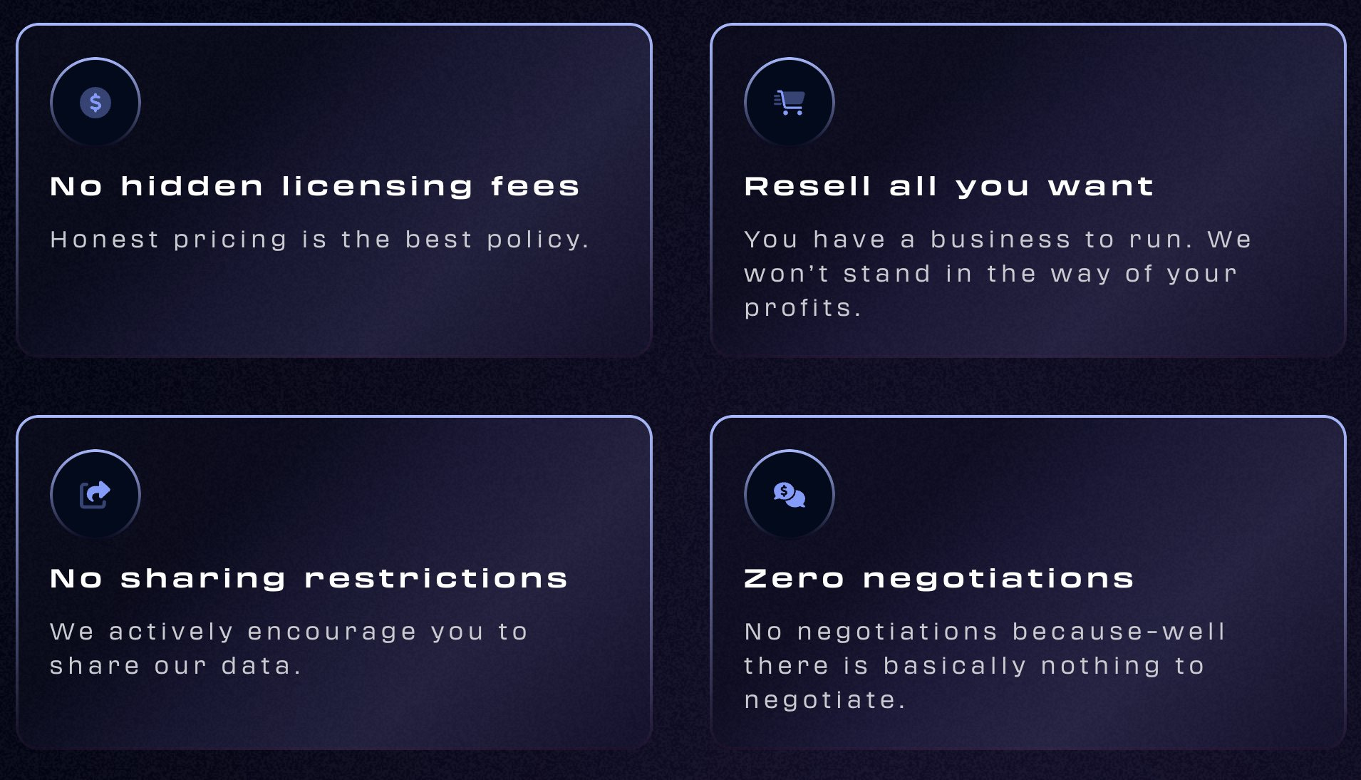
On #2, I believe that a data policy that is based on transparent pricing, unrestricted sharing and straightforward go-to-market strategy is the first step towards unlocking a future in which tens of thousands of people can build impactful and useful products for tens of millions of people.
The challenges of accessing, licensing, distributing and using EO data is quite well-known - I wrote about the recent case of the struggles of folks building disaster response tools in Turkey and Syria following the recent earthquake, unable to access, use or share satellite imagery from sources. I am excited that this first-move from Umbra will be a start in solving these problems.
While this is not the end of all challenges in EO, it certainly looks like the beginning of an end to some that have restricted the growth and adoption of EO. We still have a lot of work to do. With pricing and licensing out of the way, we need to start building those enabling tools that will empower the tens of thousands to take advantage of this revised data policy, so that they can create useful, usable data products that can then be used by tens of millions of users, and get us closer to making EO mainstream.
7. More Data Fusion: IoT and Earth Observation
I am not done with data fusion yet. This time, it is more about combining data from satellites with data from in-situ sensors connected through satellites. I have been doing a lot of thinking around this which prompted this tweet.
We are yet to see a lot of activity in the fusion of IoT and Earth observation. In other words, the combination of in-situ data transmitted through satellites fused with remotely sensed satellite data. Seeing many use cases in agriculture, mining, energy, wildfire tracking, etc.
— Aravind 🌍 🛰 (@aravindEO) 1:52 PM ∙ Feb 17, 2023
Thankfully, I was not the only one thinking about it as I had just happened to learn ESA had in fact, organised a workshop on this very subject. While I have a few thoughts on why this hasn’t yet happened in a large way within the industry, here are some developments in the IoT space that ignited the idea:
- John Deere announcement in January that they were “finalising a satellite partner” in order to build a geospatial map that farmers can use to better track productivity and the performance of crops.
- Announcements (like this one and this one) from Australian satellite IoT company, Myriota, focusing on water monitoring for the agriculture sector.
- Australian satellite IoT startup Fleet Technologies to provide connectivity services to mining firm Infinity Mining for supporting exploration activities.
- German wildfire monitoring startup, Dryad, which raised funding last year for early wildfire detection by monitoring environmental variables using IoT.
While there are several more use cases for satellite IoT, I was startled not to find more examples that combined the potential of fusing in-situ data and data from satellites. Perhaps, it is a matter of time and it will come as the EO sector opens up as it looks towards solving its accessibility, affordability and licensing issues.
In any case, I always tell myself the following and keep it at the back of my mind as I explore ideas - whatever technology we depend on, it all comes down to this:
The value of Earth observation is typically an actionable alert, a scalable API or an insightful dashboard - that is all customers pay for. Everything else (data, processing and analysis) quietly go on in the background!
One Podcast Episode
From the TerraWatch Space podcast
8. Why and How SatSure Decided To Launch Their Own High-Resolution Imaging Satellites
There are only a handful of companies in Earth observation who started with a product, offering solutions based on EO data, then decided to go up the value chain and launch their proprietary satellites - SatSure, which was in the news recently, is one of them and I wanted to know why.
So, I had two executives from the company on the podcast to discuss why they decided to launch their own satellites, the pricing of satellite imagery and whether it is a suitable model for the developing world, on-board processing and what that brings, and more. Tune in for some interesting thoughts!
Subscribe for more Earth observation insights!
Until next week,
Aravind.


