Welcome to the first edition of ‘Last Week in Earth Observation’ for 2025 - as always, it contains a summary of major developments in EO from the last week and some exclusive analysis and insights from TerraWatch.
Four Curated Things
Major developments in EO from the past week
💰 Contractual Stuff: Funding, Contracts and Deals
Contracts
- Airbus won a multi-year contract from the Dutch Ministry of Defence to provide satellite data through its OneAtlas platform;
- Maxar was awarded a €13.6M contract by the Dutch Ministry of Defence for a four-year subscription to the Maxar Geospatial Platform.
📈 Strategic Stuff: Partnerships and Announcements
Announcements
- Hyperspectral data provider Pixxel has announced a partnership with SI Imaging Services, a South Korean satellite data provider;
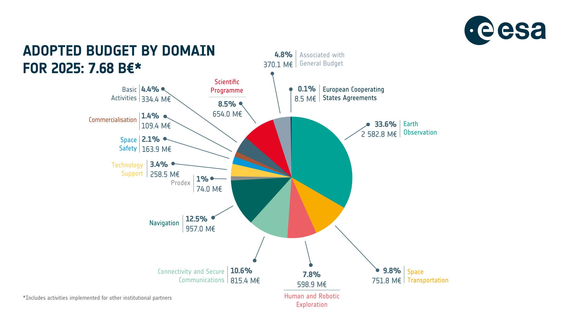
- ESA announced its budget for 2025 - while slightly lower than the previous year, EO continues to be the largest share thanks to national EO initiatives;
Note: ESA's EO budget should not be confused with the overall European EO budget which includes the EU's contributions for the Copernicus programme, EUMETSAT's contributions for weather satellites, country-level programmes for civilian and military EO satellites.

🗞️ Interesting Stuff: More News
- The Japanese government has granted Cambodia satellite images, thematic maps, 3D city planning data and a geospatial data platform valued at approximately $7.2 million;
- SpaceX launched the seventh mission adding to the US National Reconnaissance Office’s proliferated spy satellite constellation;
- The Spanish Balearic Islands are planning to launch an EO satellite, to be built by Open Cosmos;
- The EU's Copernicus Climate Service confirmed that 2024 was the warmest year on record dating back to 1850, with all the 10 warmest years occurring in the past decade.

🔗 Click-Worthy Stuff: Check These Out
- This article presenting a summary of the total insured losses from natural disasters in 2024, amounting to over $140B;
- This paper with the results of a single-blind test of nine methane monitoring satellites, showing their effectiveness and required improvements;
- This piece that discusses how the NASA-ISRO mission, NISAR to be launched later this year, will provide a unique perspective.

EO Summit: First Round of Sponsors
I am very excited to announce the first round of sponsors of EO Summit 2025. Stay tuned for more!
A few sponsorship slots are still available. For more details, check out the sponsorship brochure.

One Discussion Point
Exclusive analysis and insights from TerraWatch
Predictions for EO in 2025
Last week, I published a deep-dive looking back at what happened in the EO sector in 2024 and what to look forward to in 2025, along with a list of some predictions for the year. Which ones do you disagree with?
1/ Governments will continue to be the largest customer of EO satellites, data and analytics 🏛️
2/ Sovereign EO initiatives are not going away, but their long-term sustainability will come into question 🚩
3/ A new future for civilian EO could emerge with the rapid growth in the launch of commercial remote sensing satellites 🌍
4/ Private investments in EO may pick up again, but probably will not peak 💸
5/ Consolidation will shape the EO market more than ever before ↕️ ↔️
6/ EO for climate may take a back seat but climate will not 🌍
7/ More satellites, more data but increased focus on leveraging data from existing missions 🛰️
8/ Commercial adoption of EO will grow rapidly for 'value driving' use cases, but slowly for 'operational enablers' 📈
9/ Foundation models, generative AI and other buzzwords might stop being just buzzwords 💬
10/ The value of EO as a public good will become more prominent ❗
11/ Standards, analysis-ready data, black boxes and other boring problems might get more attention 🥱
12/ Operationalizing AI weather models and filling weather data gaps will remain an open discussion 🌦️
Scene from Space
One visual leveraging EO
Wildfire Damage Assessment
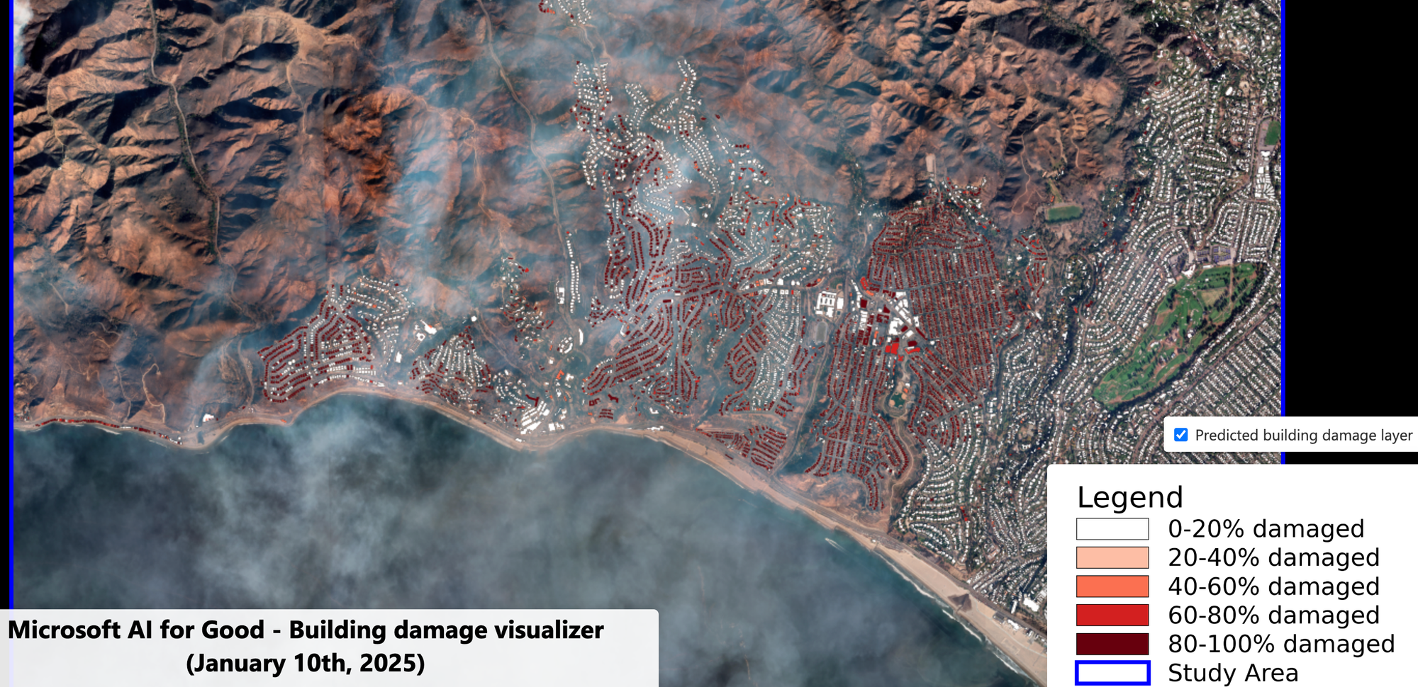
It has been horrifying to witness the evolution of the wildfires in Los Angeles from afar. Satellite imagery has been a critical tool to help us understand the scale of the disaster. The following image is from analysis done by Microsoft's AI for Good team, showing the level of damage to buildings impacted by the Eaton fire.

Until next time,
Aravind.


