Welcome to a new edition of ‘Last Week in Earth Observation’, containing a summary of major developments in EO from the last week and some exclusive analysis and insights from TerraWatch.
Quick housekeeping: The weekly newsletter will be on a break for two weeks in August - so there will be no editions on August 12 and August 19.
Four Curated Things
Major developments in EO from the past week
1. Contractual Stuff: Funding, Contracts and Deals 💰
Funding
- First Street, a US-based physical climate risk data provider leveraging EO among other data sources raised $46M in a Series A-1 funding round;
- Italian EO analytics solution provider Latitudo 40 has raised an undisclosed investment in a post-seed funding round;
- Mitti Labs, an Indian startup raised $3M in a seed round to tackle methane emissions in rice farming using AI and satellite data.
Contracts
- Orbital Insight, an EO analytics firm (acquired by Privateer), has won a $2M contract from the U.S. National Geospatial-Intelligence Agency for providing commercial geospatial data services;
- Planet was awarded a seven-figure contract expansion with a US-allied International Government Agency for SkySat high-resolution satellite data;
- Planet also extended its contract to provide data to the Taylor Geospatial Institute, a geospatial research consortium until 2026;
- Canadian hyperspectral satellite firm Wyvern won a CAD 5M contract to launch a satellite for wildfire monitoring and methane leak detection;
- Thales Alenia Space was awarded French government funding to develop a constellation of satellites for high-resolution detection of CO2 emissions.
2. Strategic Stuff: Partnerships and Announcements 📈
Partnerships
- NOAA has partnered with United Airlines to install instruments on a Boeing 737 to measure greenhouse gases and other pollutants during domestic flights, which is useful for validating satellite measurements;
- Japanese EO firm Axelspace is partnering with the Maldives Space Research Organisation to provide satellite imagery of the country.
3. Interesting Stuff: More News 🗞️
- The Indian government has released an expression of interest to invite Indian companies interested in building and managing a multi-sensor EO satellite constellation, on a public-private partnership model;
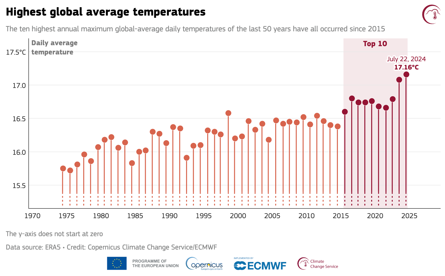
- According to data from the EU’s Copernicus Climate Change Service, our planet just experienced its warmest day in recent history.

4. Click-Worthy Stuff: Check These Out 🔗
- This article that discusses the history and consequences of using EO data as digital evidence in legal cases;
- This piece about a recent AI model from Google that is capable of accurately predicting long-term climate trends and weather in minutes;
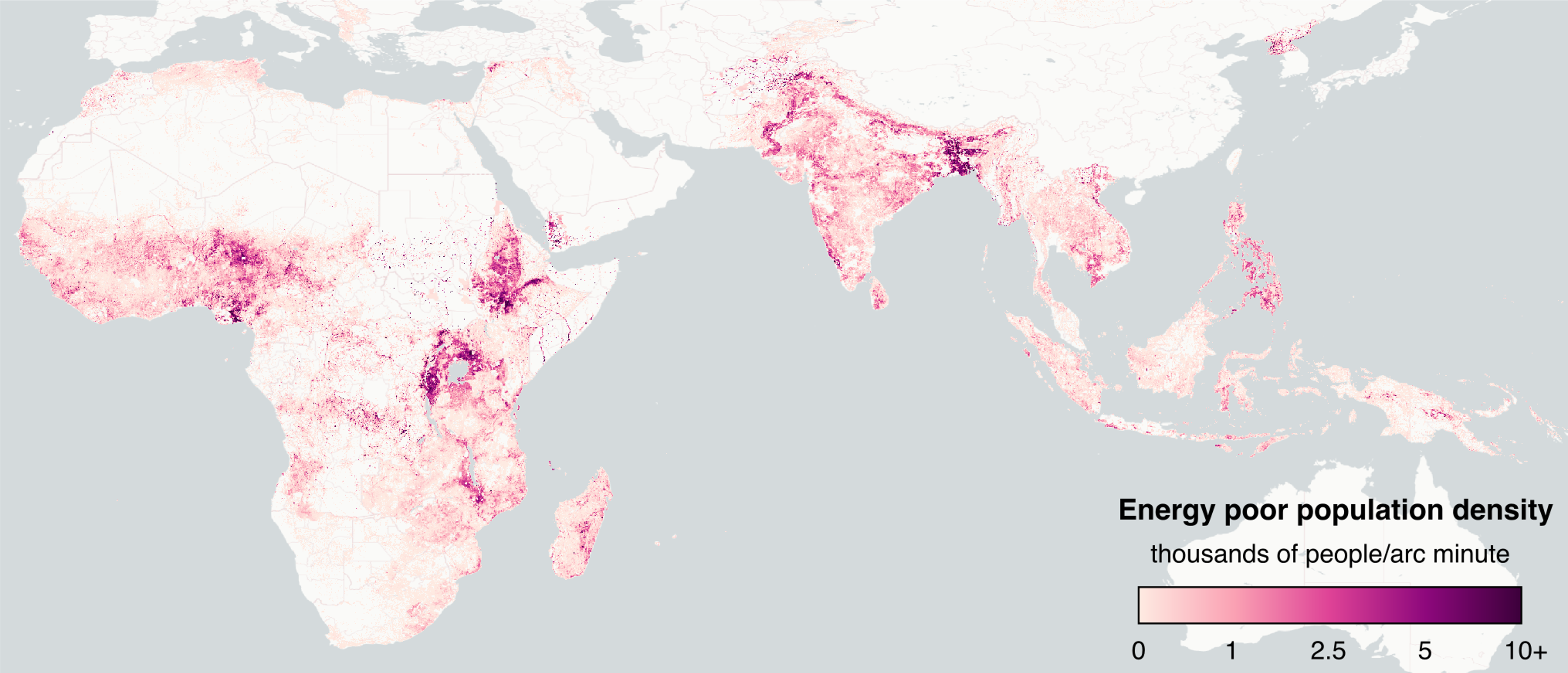
- This article from the World Bank that discusses how day-time and night-time satellite imagery was used to identify that about 1.18 billion people live in energy poverty despite rising electricity access.

One Discussion Point
Exclusive analysis and insights from TerraWatch
5. EO for Climate Adaptation
If you want a primer on EO for climate, check out the deep dive from TerraWatch on the state of EO for climate.
Weather is just the manifestation of climate change and whether we like it or not, we need to invest in solutions that can help us adapt to the changing climate - and guess what, we have some data to show from early warning weather systems that they do work concerning saving lives, but economic losses continue to increase as the global economy continues to grow. We have a lot of work to do to save lives equally around the world and develop solutions that can help anticipate such events and effectively prepare for them.
EO has a crucial role to play in building such adaptation tools and we have already seen them being used - weather forecasting is the most widely used application of EO. “EO for Climate Adaptation” is a complex market to comprehend, as it might seem like several companies are working on the same type of application, at least from their websites - thanks to the usage of buzzwords like intelligence, risk, insights, etc.
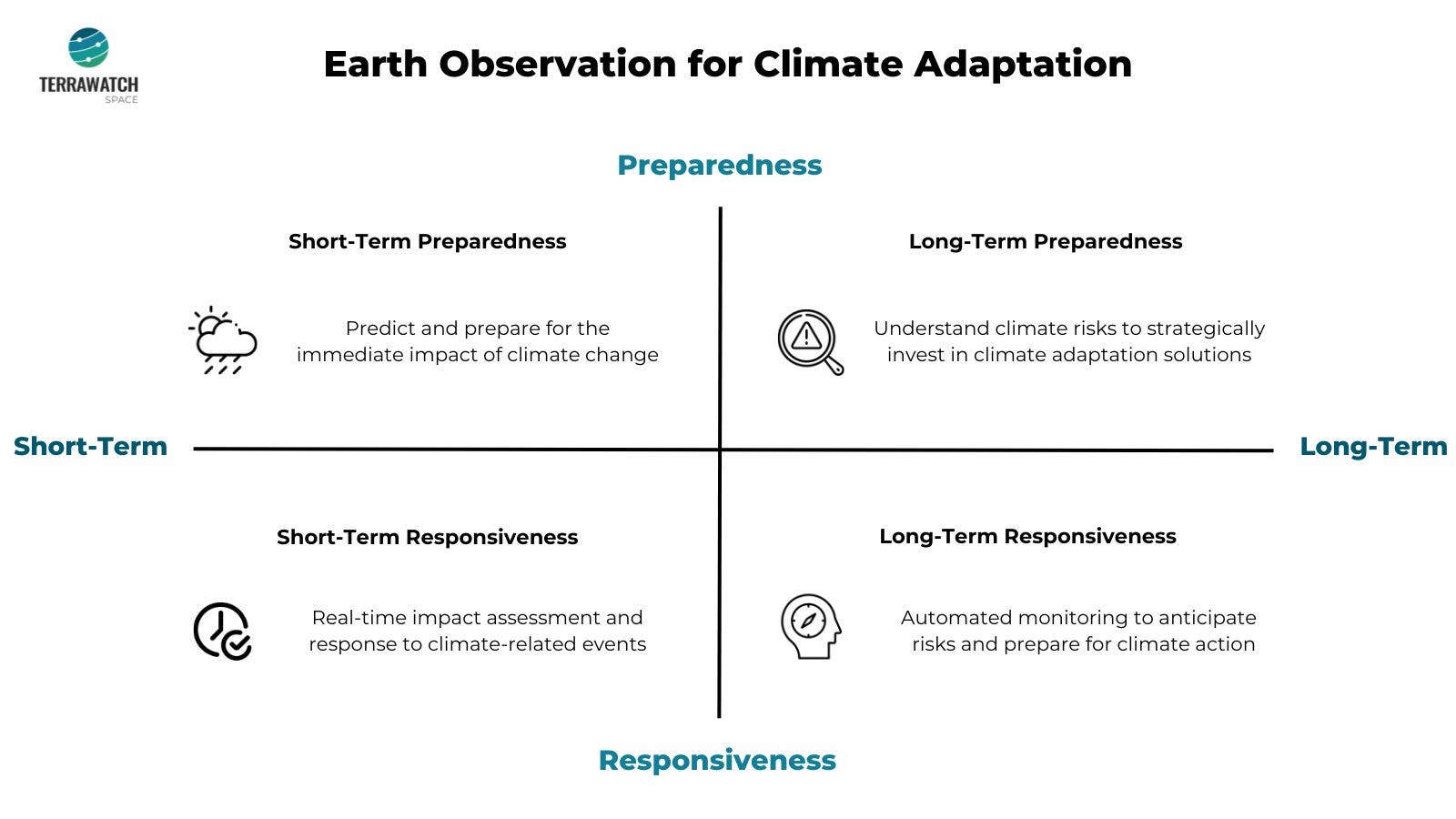
I figured there should be a better way to understand this fast-growing, yet important market segment within EO, especially if you are an outsider looking in. So, I came up with four categories of EO Climate Adaptation companies - classified based on Impact and Time frame.
- Impact - Preparedness vs Responsiveness: Is EO applied for building tools to prepare for or respond to the impacts of climate change?
- Time frame - Short Term vs Long Term: Is EO used to develop solutions that would be used in the next few days/weeks or the next few years/decades?

The above framework provided me with four categories of companies, as seen from the four quadrants of the figure above:
- Those working on predicting and preparing for the immediate impact of weather impacting several industries at once —> Short-Term Preparedness
- Those working on understanding climate risks for assets, infrastructure and people in the not-too-distant future —> Long-Term Preparedness
- Those providing real-time impact assessment and disaster support to respond to ongoing climate change —> Short-Term Responsiveness
- Those enabling automated monitoring of assets to respond efficiently by anticipating risks —> Long-Term Responsiveness
I will leave it to you to categorise and position companies in the EO for climate commercial landscape on the four quadrants - it is a fun exercise to try on companies you come across leveraging EO data to build climate-related solutions. You will be able to quickly see in which category we have too many solutions and in which one, we have too few solutions.
Scene from Space
One visual leveraging EO
6. Carbon Dioxide Emissions Visualised
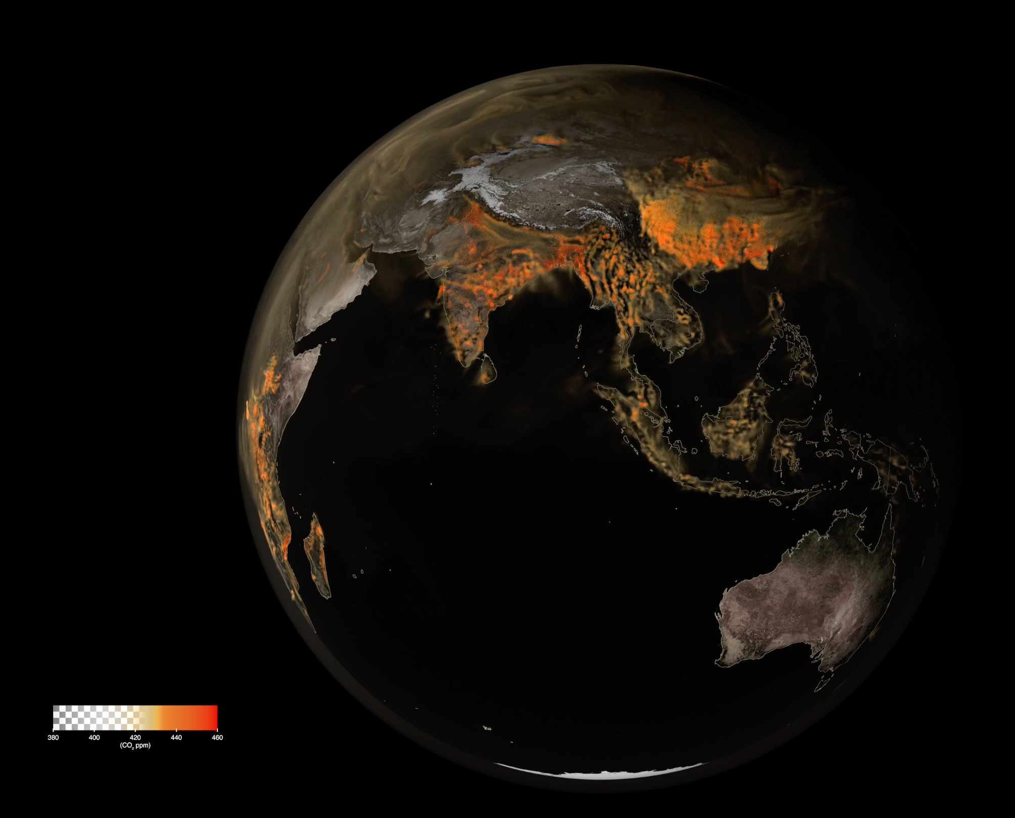
NASA published an incredible visualisation (click to see) of the flow of carbon dioxide around the planet emitted from various sources in high resolution. The animation shows the movement of carbon dioxide through Earth’s atmosphere from January through March 2020, driven by wind patterns and atmospheric circulation. You will also be able to see the absorption and release of carbon dioxide as trees and plants photosynthesize.
The animation constructed using NASA’s GEOS model uses billions of data points from ground observations and satellite instruments, such as the Terra satellite’s MODIS and the Suomi-NPP satellite’s VIIRS instruments.

This is a reader-supported publication. To access exclusive deep dives, market briefings and the newsletter archive, become a paid subscriber. If you want to show your support, you can also make a one-time donation here.
Until next time,
Aravind.


