

Welcome to another belated edition of ‘Last Week in Earth Observation’, containing a summary of major developments in EO from the last week and some exclusive analysis and insights from TerraWatch.
Four Curated Things
Major developments in EO from the past week
💰 Contractual Stuff: Funding, Contracts and Deals
Funding
- SAR-based 3D imaging satellite firm Array Labs received an undisclosed investment from defense-tech investor In-Q-Tel;
- Floodbase, a EO-based parametric solution provider raised $5M investment to accelerate development of flood insurance programs;
- Indian SAR startup Sisir Radar raised $1.5M with an aim to launch the world’s highest resolution L-band SAR satellite by the end of 2026;
Contracts
- Weather solution provider Weather Stream was awarded a $2M contract from the Office of Naval Research (ONR) to develop a multi-model platform for environmental remote sensing;
- India's space commercialisation agency IN-SPACe selected startups including Suhora, Pier Sight, Kawa Space and ClimaCrew for marine sector projects;
- BlackSky won a multimillion-dollar contract from the Defense Innovation Unit, for which it will build and launch a Gen-3 high-resolution satellite;
📈 Strategic Stuff: Partnerships and Announcements
Announcements
- Japanese IT firm NTT Data has announced the development of a high-resolution, high-frequency 3D imaging satellite system in a joint venture between Pasco Group and Canon;
- Kapta Space exits stealth mode with plans launch radar satellites with metasurface antenna technology for continuous target tracking from orbit;
- Planet announced an expanded relationship with agrichemical firm Bayer through a multi-year enterprise license agreement;
- Esri, in partnership with SkyWatch, launched Content Store for ArcGIS, a new web app that simplifies the process of purchasing and integrating commercial satellite imagery;
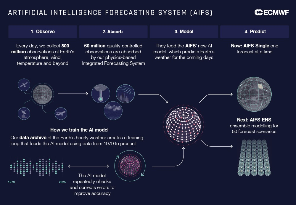
- European weather agency ECMWF made its AI weather model operational, running side by side with its traditional physics-based weather model.
My take: I think physics-based traditional weather models are complementary to AI weather models - at least until we can fill global data gaps and/or have the capability to assimilate real-time observations. So, we should not be thinking of this as an either-or question.
🗞️ Interesting Stuff: More News
- Over 800 employees of NOAA have been laid off potentially impacting weather forecasting in the US and around the world;
- Singapore has set up an EO initiative focusing on solving Asia-Pacific’s issues such as food and water quality, disaster and disease monitoring as well as forestry and land management;
- UAE is expected to launch a SAR satellite manufactured by South Korean firm Satrec Initiative;
- China launched a pair of SuperView Neo-1 satellites capable of providing high-resolution (30 cm) imagery;
- Kanyini, an Australian satellite, that includes an hyperspectral imager and an IoT sensor has successfully transmitted its first images from space.

🔗 Click-Worthy Stuff: Check These Out
- This article on EO satellites flying in very low Earth orbits;
- This paper that argues that satellite imagery is a distinct modality in machine learning research;
- This deep dive on global EO civilian programs, budgets and trends.
One Discussion Point
Exclusive analysis and insights from TerraWatch
AI for Weather Forecasting
There is a silent revolution going on in the weather world powered by AI. The European Centre for Medium-Range Weather Forecasts has introduced the Artificial Intelligence Forecasting System (AIFS), a data-driven ensemble weather forecasting model, similar to those developed by Google, Huawei & NVIDIA.
So, what's the big deal about this one? First, some basics.
Context
Weather forecasting models can be classified into two - deterministic and ensemble.
Deterministic models
Deterministic models provide a single forecast based on a given set of initial conditions of the atmosphere, for a specific location and time - essentially the 'best forecast' within the laws of physics. These are great for short-to-medium-term forecasts (7 days).
While deterministic models can be really accurate due to the potential for high-resolution forecasts in the best-case scenario, they can also be way off especially due to the range of possible states of the atmosphere and the uncertainties associated with 'guessing' them. Enter ensemble models!
Ensemble models
Ensembles run many simulations accounting for all the uncertainty in the initial conditions of the atmosphere and, hence provide several possible results. These are great for medium-to-long-term forecasts (up to 2 weeks) esp. by comparing the results.
Ensemble models (like the AIFS by ECMWF) are inherently probabilistic - if 90% of the results predict heavy rain, there is high confidence in the forecast. Similarly, even if only 10% of the results predict a storm, it can facilitate early warning systems and support disaster management.
Why ECMWF’s AIFS is significant?
AI and weather forecasting are truly a match made in the atmosphere. With a given set of data and boundary conditions, the AI model is capable of generating hundreds to thousands of simulations which can help us forecast that disaster, that we may have missed before. This is important especially for climate adaptation plans, given the rise in frequency and/or intensity of natural disasters. I am excited about the possibility of having better early warning systems in the global south, which suffers more due to the lack of weather infrastructure, which is slowly being filled with more weather satellites.
In addition, seeing a public-sector organisation keep up with the private sector advancements and continuously innovate is great. This is fundamentally important as I believe weather is a public good (free/open) and should always be.
Finally, it is amazing that the model and its source code will be open-source. This means that anyone in the weather community can use the AIFS model and identify strengths and weaknesses so that the forecasts become better.
— — —
For more on weather from space, check out this free deep-dive from a couple of years back. An update to this is coming up in April. Stay tuned!
Scene from Space
One visual leveraging EO
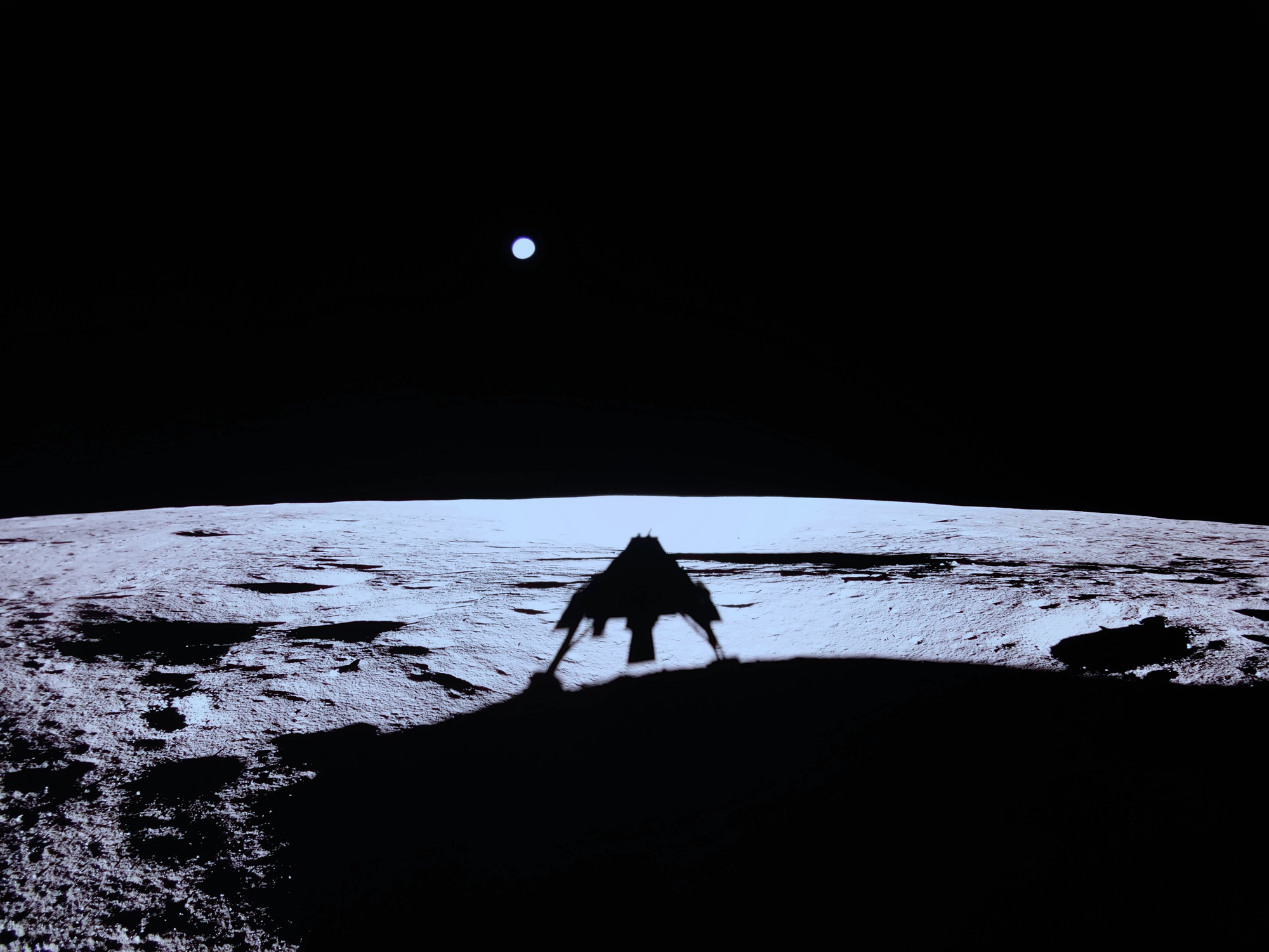
Observing the Earth from the Moon
In this section, I usually share visuals, data and insights about our planet observed from satellites on the Earth orbit, but on the heels of the first fully successful lunar landing by a private company, it might be worth zooming out a little.
We haven't had many images of the Earth taken from the surface of the Moon, for a while, especially after the famous Earthrise and the Blue Marble photos. But, with a new era of lunar exploration upon us, I think we will be able to get more such shots of our planet.
While it is certainly not going to be revolutionary from an EO standpoint, perhaps, looking at the pale blue dot, in its essence, will bring us all a little closer together.
Until next time,
Aravind.


