

Welcome to a (very) belated edition of ‘Last Week in Earth Observation’, containing a summary of major developments in EO from the last week and some exclusive analysis and insights from TerraWatch.
Four Curated Things
Major developments in EO from the past week
💰 Contractual Stuff: Funding, Contracts and Deals
Funding
- OroraTech extended its Series B round to €37M with investments from leading European banks, BNP Paribas and Rabobank Group.
Related: This deep-dive from TerraWatch on EO for wildfire monitoring
Contracts
- Iceye signed an agreement with the Polish ministry of defense to deliver an initial batch of three SAR satellites, with an option to purchase three more;
- Satellogic and BlackSky signed contracts with international customers.
Earnings
- Spire reported $23.9M in revenues for Q1 2025, a decline compared to $34.8M in reported in Q1 2024.
📈 Strategic Stuff: Partnerships and Announcements
Announcements
- Geospatial services provider Woolpert has acquired UK-based aerial survey firm Bluesky International.
🗞️ Interesting Stuff: More News
- The Arab world’s first joint EO satellite will be launching in June;
- Lawmakers in the US are raising alarms over rumored cuts to commercial satellite imagery procurement;
- India is fast-tracking plans to launch its military satellite constellation, following the recent conflict;
- India's launch of EOS-09 SAR satellites failed, while Rocket Lab and China launched multiple SAR satellites;
- China also launched the first of 2,800 satellites for AI edge computing constellation.
🔗 Click-Worthy Stuff: Check These Out
- This article that presents a new peat map for England showing that 80% of England's peatlands to be dry and damaged;
- This piece showing how EO companies are teaming up to tip and cue one another.
EO Summit: Last 2 Weeks of Ticket Sales
Ticket sales for EO Summit close in 2 weeks!
Join 120+ organizations and 80+ experts in New York this June to explore the most impactful EO applications and use cases.

One Discussion Point
Exclusive analysis and insights from TerraWatch
The Future of EO-Derived Climate Risk Data
The risks associated with climate change are typically divided into two categories: physical and transition risks. Even though they are categorised into two groups, all the climate-driven risks are interconnected. The earlier we take action (i.e. reduce our dependence on fossil fuels and protect biodiversity) managing the transition risks, the more manageable the physical risks might be. The longer we wait, the worse both risks become for everyone.
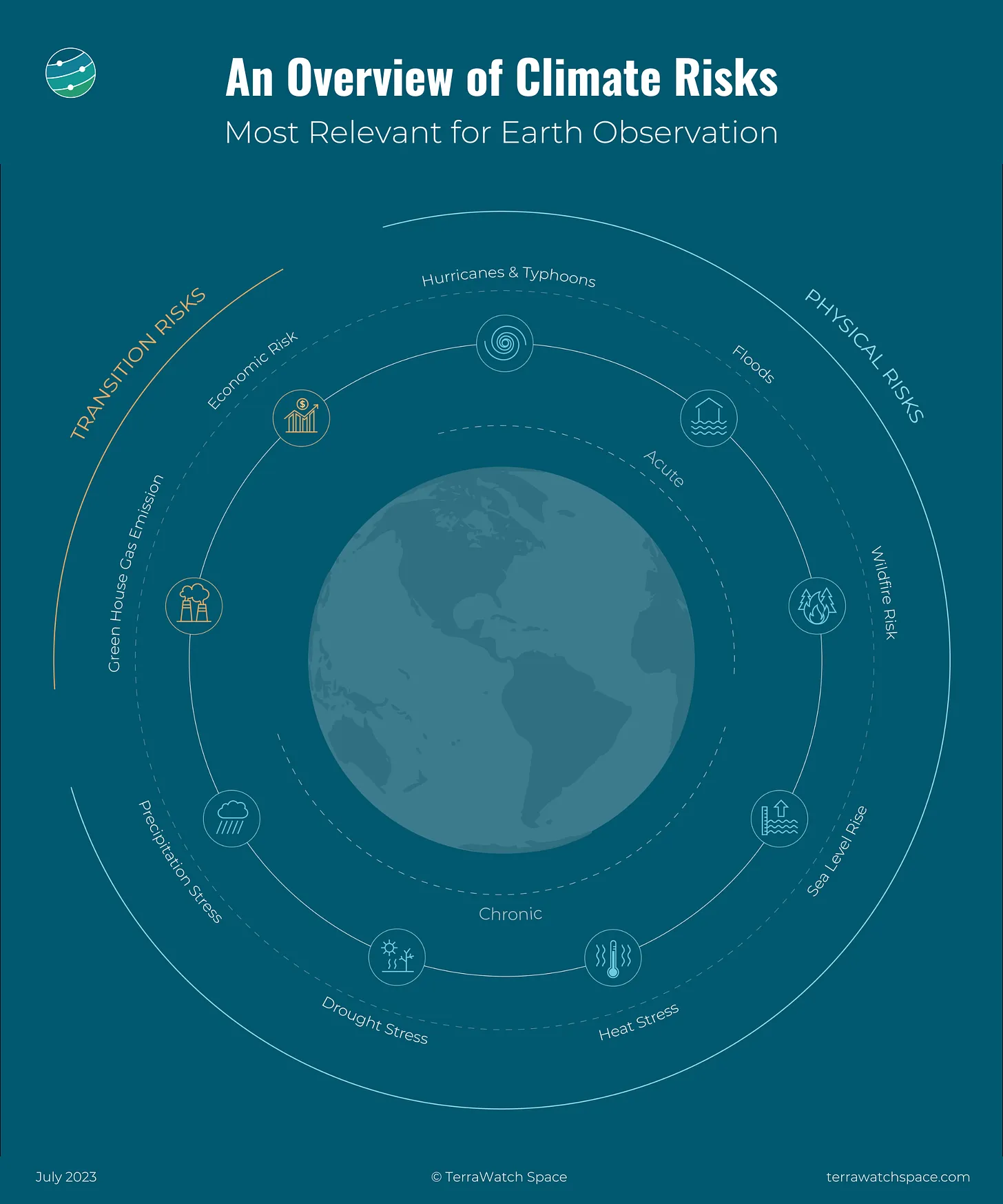
EO and Climate Risk
Data acquired from the different types of sensors provide crucial information for most of the climate risks. Satellites launched by governmental agencies have been collecting data about the state of the planet and our activities on it for more than five decades. That coupled with data from emerging commercial satellites and a variety of other sensors (drones, aerial, balloons, weather stations and other ground sensors) play a distinct role in understanding climate risk, serving as inputs to the climate models around the world.
Check out the deep dive on EO for Climate Risk which includes an introduction to climate risk, the types of risks, the importance of EO, an overview of the landscape for measuring, reporting and responding to climate risks and some examples of climate risk in use.
Climate Risk in the Real Estate Market
EO-derived climate risk data is becoming mainstream in the real-estate market. It is difficult to think of a future when any large infrastructure or property-related decisions are made without assessing the flood, wildfire, heat and sea level risks, supported by long-term satellite observations and records.
First Street, an US-based organisation that provides climate risk data for real estate firms has had success recently seeing its proprietary models integrated into prominent property marketplaces such as Zillow, Realtor, Redfin, Homes. com etc.
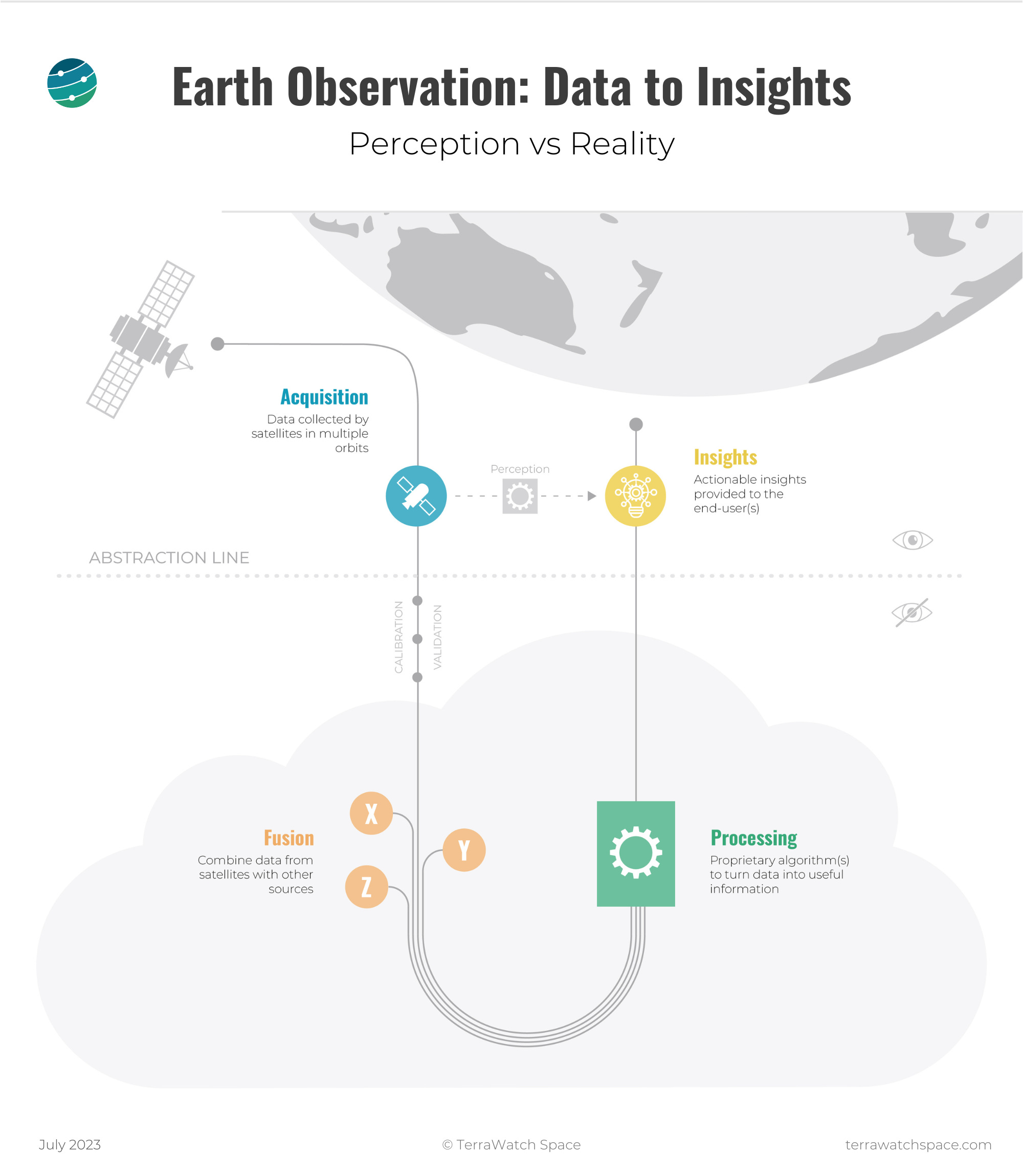
The Black Box Problem
With a growing number of commercial climate risk solutions in the market, one subject that does not get the attention is the the black-box problem i.e. the challenges associated with evaluating the validity and uncertainty of the various climate risks models and benchmarking them.
There is a very limited understanding of the steps involved in the transformation of data derived from satellites into actionable insights, in this case, inputs to the climate risk models. As the figure below shows, different datasets might lead to different results, especially as the output depends on each of the steps in the process, coupled with a possible subjective nature of the contextualised insight.
So, as much as we focus on the role of commercial EO in offering insights to solve a particular climate-related problem, it is equally, if not more, important to be able to fully understand how the insights were derived. Whether it is through continued peer-reviewed publications, complete transparency through an open-source model or simply letting the market decide, that remains to be seen.
Scene from Space
One visual leveraging EO
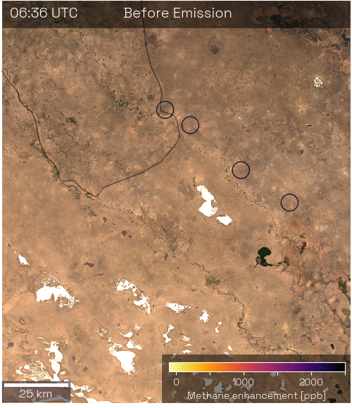
Real-Time Tracking of Methane Emissions
Researchers at SRON have developed a new satellite-based method to rapidly detect and pinpoint large, short-lived methane emissions.
By combining data from ESA’s Sentinel-5P satellite with data from NOAA's VIIRS sensors, they can now identify major leaks—such as a 1.5-kiloton methane release from a pipeline in Kazakhstan—within hours.
The image below shows how emissions of more than 1.5 kilotons of methane released in less than an hour were spotted by satellites.
Until next time,
Aravind.


