

Welcome to a new edition of ‘Last Week in Earth Observation’, containing a summary of major developments in EO from the last week and some exclusive analysis and insights from TerraWatch.
Four Curated Things
Major developments in EO from the past week
💰 Contractual Stuff: Funding, Contracts and Deals
Funding
- Xoople, a Spanish EO firm, emerged from stealth with €115M in funding;
- Saudi Arabian EO startup SARsatX raised $2.6M in seed funding to provide SAR services;
- Indian EO startup PierSight raised an undisclosed amount as additional capital in a seed extension round.
Contracts
- Ursa, University of Illinois and Palantir won contracts worth tens of millions of dollars each from the National Geospatial-Intelligence Agency.
📈 Strategic Stuff: Partnerships and Announcements
Announcements
- Microsoft announced the launch of Microsoft Planetary Computer Pro, a platform to ingest, catalog, store, process, and disseminate geospatial data;
- South Korean EO provider SI Imaging Services unveiled its new offer to lease capacity from its high-resolution imaging satellite;
- UAE-based satellite manufacturer Orbitworks announced plans for a 10-satellite, AI-enabled EO constellation.
Partnerships
🗞️ Interesting Stuff: More News
- The US National Reconnaissance Office has warned of potential funding cuts that could slash as much as one-third from the previously projected $450 million commercial imagery budget for the upcoming fiscal year;
This signals three potential shifts for EO satellite companies:
i) diversify revenue streams and expand internationally,
ii) accelerate adoption of EO in commercial use case, and
iii) push toward deeper partnerships or consolidation for survival.
It’s yet another reminder that government demand is not and will not be guaranteed. Long-term sustainability in EO will depend on building broader market traction and more resilient business models.
- Open AI demonstrated some of the geospatial capabilities of OpenAI’s new models at the GEOINT conference.
🔗 Click-Worthy Stuff: Check These Out
- This article that digs deep into the Microsoft's Aurora AI foundation model and how it goes beyond weather forecasting;
- This article that discusses the role of the National Geodetic Survey in maintaining spatial information in the US (and why it is under threat);
- This article that presents how geospatial analysis can lead to understanding nature risks.
Related: The TerraWatch deep-dive on EO for biodiversity monitoring
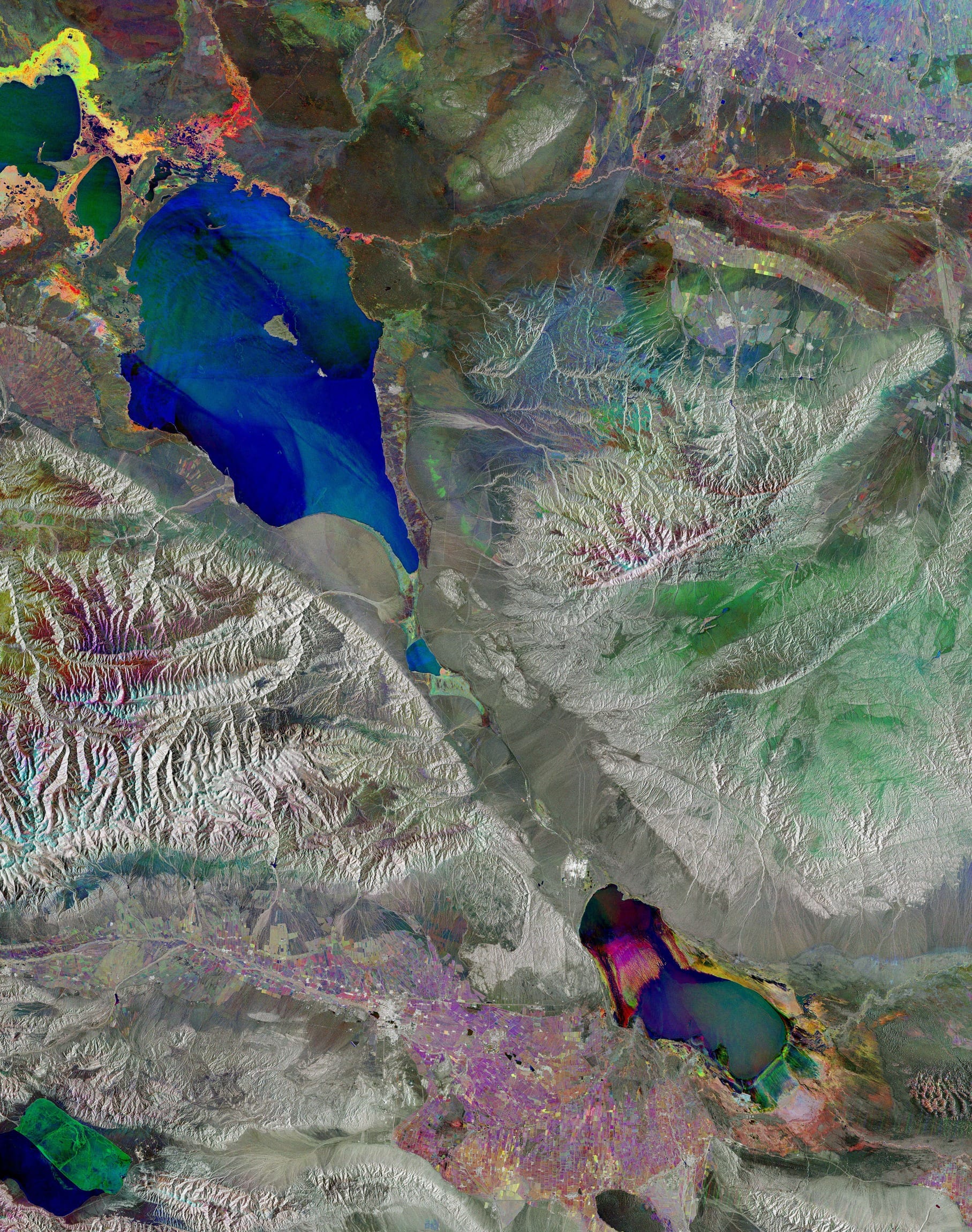
- This false-colour image from ESA of a multi-coloured lake in Kazakhstan.
EO Summit: Last Week of Ticket Sales
🛰️ Just 2 weeks to go until EO Summit 🌍
EO Summit 2025 will have a unique program, with over 80 carefully curated speakers from a dozen different industries and over 120 participating organizations (see below) to discuss over 40 applications of EO.
Reserve your tickets before ticket sales close on June 2!

One Discussion Point
Exclusive analysis and insights from TerraWatch
Why are Google and Microsoft building AI weather models?
In the last few months, Google released GraphCast, a machine learning-based global weather forecasting model, and Microsoft followed with Aurora, its own AI weather models. Both claim faster, cheaper, and more accurate forecasts than traditional models.
I think the real story here is not about weather accuracy, and it is definitely not about replacing ECMWF or NOAA in the future.
This is really about weather becoming part of the cloud infrastructure, about turning forecasting into a cloud-native service that’s deeply embedded within their compute ecosystems. So, really the move has less to do with weather itself, and everything to do with their platform strategy.
Making Weather as the Sticky Layer
For sectors such as energy, insurance, agriculture, logistics and finance, weather is not just data, it is a key decision driver. If you can offer native, on-demand, customisable forecasts, users will start building their products and workflows around you: models, simulations, dashboards, alerts and triggers, aka a sticky service layer.
And this goes beyond just weather. The AI models they are building extend to air quality, wildfires, floods, and broader Earth system monitoring, expanding the strategic value even further across more use case.
So, instead of calling external weather APIs or downloading gridded files from public agencies, users will, in the future, be able to:
- run forecasting models on demand within their cloud environments, and generate forecasts dynamically,
- combine forecasts with proprietary data collected via IoT, historical archives and other sources,
- create custom workflows to be able to automate decisions and actions - triggers, alerts, dynamic pricing etc.
The big advantage? All of this takes place within their native environments using existing tools they are using BigQuery / Synapse / Redshift and their proprietary data pipelines. Once that happens, migrating away is not going to be inconvenient as it becomes expensive, time-consuming, and operationally disruptive.
Simply put, the goal is make weather become part of the glue that makes cloud platforms sticky i.e. a service that users build around, integrate with, and ultimately depend on for their business.
It follows the same logic that made maps (think Google Maps), payments (think Stripe) and cloud-native data warehousing (think Snowflake) part of the modern platforms: embed a critical service, make it programmable, and turn it into infrastructure.Once the service powers forecasts, decisions, or operational workflows, it’s no longer just a feature, it is foundational.
TL;DR: I think Google and Microsoft are trying to make weather foundational by turning it into a programmable infrastructure layer, that powers the horizontal layer of weather intelligence and climate services.
PS. Don't Forget NVIDIA
While Google and Microsoft are building the service layer for weather intelligence, NVIDIA is playing a different but equally critical role.
Through its high-performance GPUs, developer frameworks like Modulus, and its Earth-2 platform, NVIDIA is positioning itself as the compute and simulation backbone for next-generation weather and climate modeling. They are not offering forecasts they’re enabling them. Not competing with cloud providers, but powering them under the hood.
For more on weather from space, check out this free deep-dive from a couple of years back. An update to this piece is coming up for the premium subscribers in June. Stay tuned!
Scene from Space
One visual leveraging EO
Forests on Fire
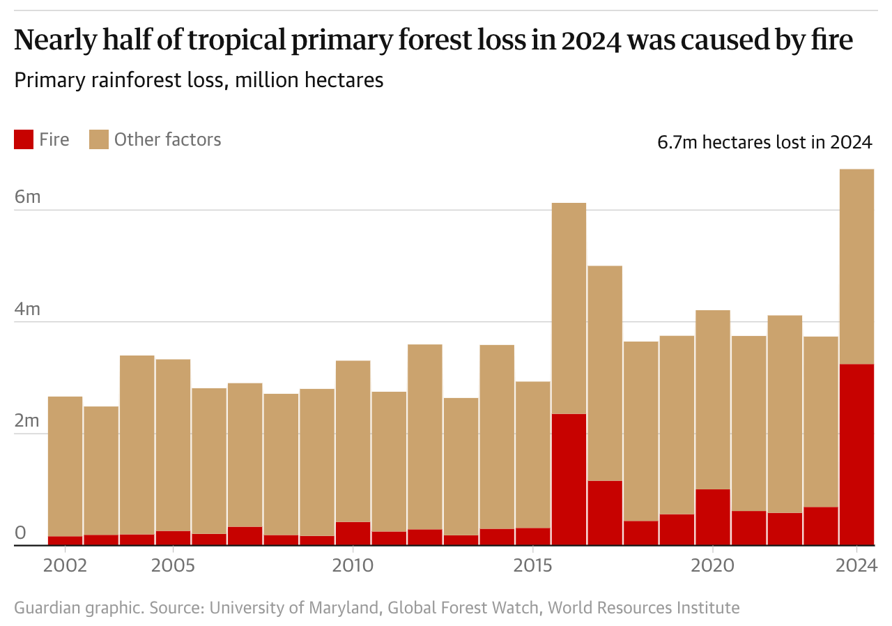
According to analysis published by the World Resources Institute, the tropics lost a record 6.7 million hectares of rainforest in 2024, an area nearly the size of Panama. While there was some good news with declines in Malaysia and Indonesia, this above figure is more than any other year in at least the last two decades, was driven mainly by fires.
Long-term satellite records like those from Landsat are a fundamental part of such analysis. Check out the article for more information on country-level trends and other factors that contributed to the deforestation.
Until next time,
Aravind.


