

Welcome to a new edition of ‘Last Week in Earth Observation’, containing a summary of major developments in EO from the last week and some exclusive analysis and insights from TerraWatch.
Four Curated Things
Major developments in EO from the past week
💰 Contractual Stuff: Funding, Contracts and Deals
Funding
- Stratospheric balloon-based image provider Near Space Labs raised $20M in Series B funding;
- India-based thermal infrared imaging startup SatLeo Labs raised $3.3M in seed funding.
📈 Strategic Stuff: Partnerships and Announcements
Partnerships
- EO-based vegetation monitoring solution provider Overstory Partner is teaming up with real-time wildfire tracking app Watch Duty;
Announcements
- Weather intelligence firm Tomorrow.io announced its microwave sounder constellation now captures atmospheric profiles over ~45% of Earth, significantly boosting global forecast coverage.
🗞️ Interesting Stuff: More News
- The US National Weather Service is reported to be in worse shape than previously known;
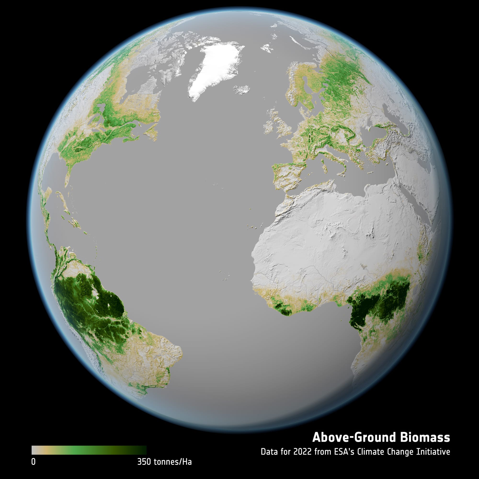
- ESA’s Biomass satellite, designed to provide insights into the world’s forests and their crucial role in Earth’s carbon cycle, has been launched;
- On the same vein, ESA also unveiled the longest-ever dataset on forest biomass, from 2007 to 2022, at resolutions ranging from 100 m to 50 km.
🔗 Click-Worthy Stuff: Check These Out
- This piece that discusses using interactive graphics about the threat that decommissioned and deorbiting satellites have on the atmosphere;
- This article that shows how 40-year-old spy satellite photos are helping find forgotten land mines in Cambodia;
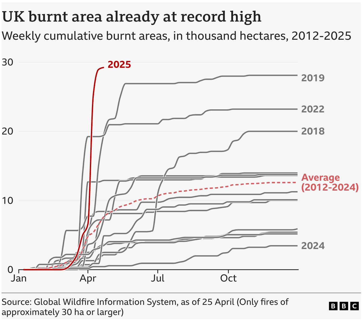
- This piece that discusses how the area of the UK burnt by wildfires so far this year is already higher than the total for any year in more than a decade.
EO Summit: Tickets on Sale
🛰️ Just 5 weeks to go until EO Summit!🌍
We have worked hard to create a unique program for the conference. We will have over 80 speakers from a number of industries, over 120 organizations attending the event and discussing over 40 applications of EO.
Reserve your tickets before we are sold out!

One Discussion Point
Exclusive analysis and insights from TerraWatch
The Future of Earth Observation in the US (Part 1)
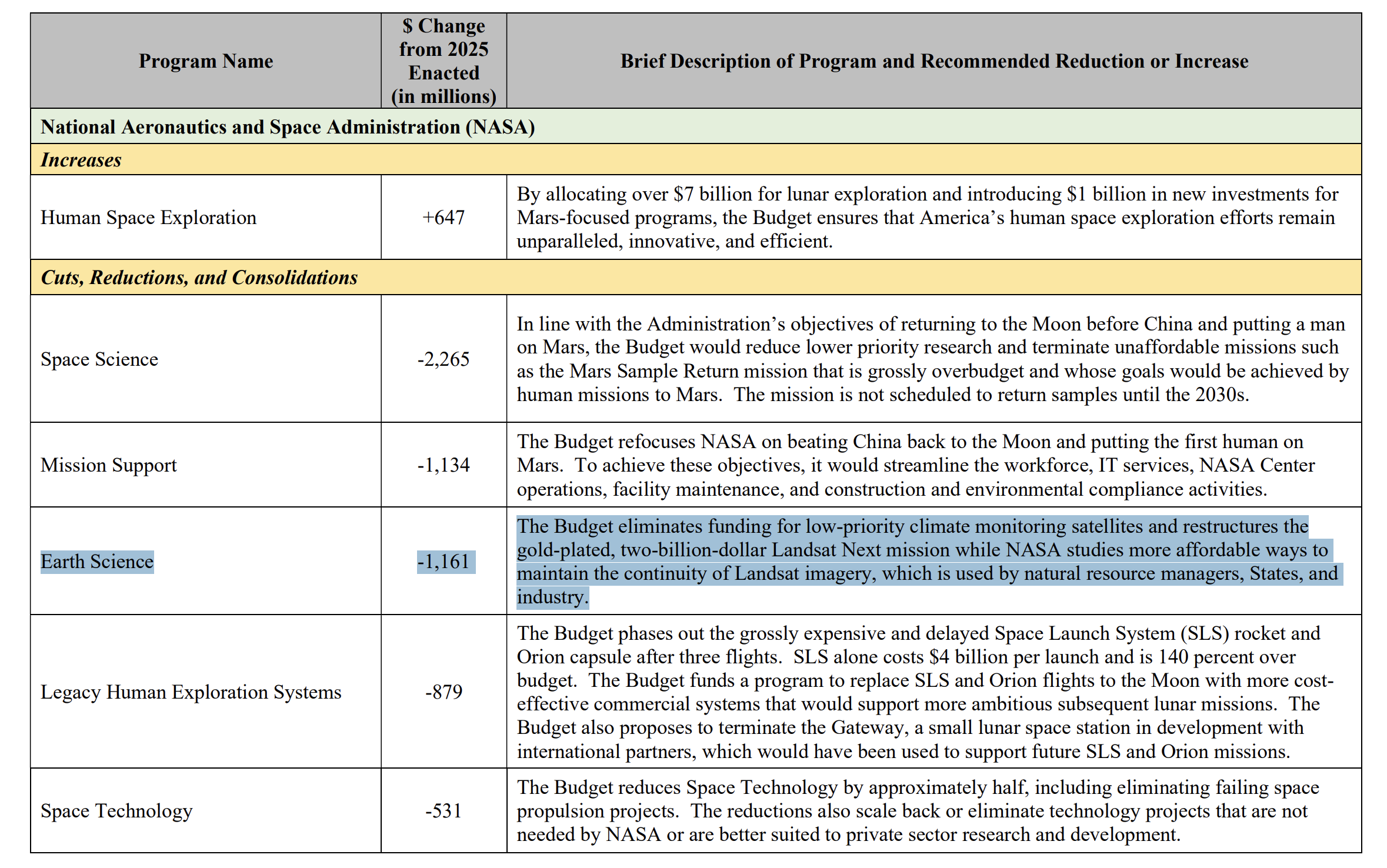
The latest NASA proposal for FY26 requests for a $1.1B (~50%) cut to Earth Science and includes two major line items that would impact the future of Earth observation:
- Cancelation of "low-priority" climate monitoring missions (likely part of the Earth System Observatory series of missions),
- Restructuring of the proposed Landsat Next missions that will provide continuity of Landsat data.
The Future of Landsat
An economic impact study published last year (which I contributed to) estimated that Landsat imagery delivered over $25B in value to the U.S. in 2023. The follow-on Landsat Next mission is projected to generate $33B+ in annual value by the 2030s.
Notably, this estimate excludes data accessed via platforms like Google Earth Engine, AWS, or Microsoft, which are widely used in the ecosystem. So, those figures very much understate the true extent of Landsat’s economic value.
There’s growing discussion — particularly within parts of the private EO sector — about whether commercial EO data providers could step in, given the rise of 75+ satellite EO companies offering data with continuously improving spatial, spectral, and temporal solutions.
But here’s the reality: Landsat (along with Sentinel-2) are still widely considered the gold standard for satellite imagery. Which leads to me two questions:
- Can any affordable alternatives for Landsat Next truly match that level of scientific and operational quality?
- How will the private EO sector respond — especially given how much they rely on Landsat for instrument calibration and also as a free, foundational dataset for building commercial solutions?
Will EO satellite companies position themselves as replacements — or advocate for Landsat’s continued role? How this unfolds over the coming years will shape the future of public-private dynamics in EO in the US.
Scene from Space
One visual leveraging EO
Real-time Wildfire Detection
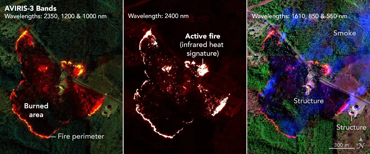
The image below shows how a NASA sensor (AVIRIS-3 i.e. Airborne Visible Infrared Imaging Spectrometer 3) recently brought a new approach to battling wildfire, providing real-time data that helped firefighters in the field contain a blaze in Alabama.
According to NASA, a scientist on the plane equipped with the instrument, analyzed the data collected in real time and identified where the blaze was burning most intensely. This information was then sent via satellite internet to fire officials and researchers on the ground, who distributed images showing the fire’s perimeter to firefighters’ phones in the field.
The process from detection during the flyover to alert on handheld devices took only a few minutes. Is this the future of wildfire detection and mitigation?
Until next time,
Aravind.


