

Welcome to another edition of ‘Last Week in Earth Observation’, containing a summary of major developments in EO from last week and some exclusive analysis and insights from TerraWatch.
In this edition: Various ways to build and launch an EO satellite, monitoring sea levels, the value chain of EO for GHG monitoring, EO for food security and more.
Four Curated Things
Major developments in EO from the past week
1. Contractual Stuff: Funding, Contracts and Deals 💰
Funding
- Finnish EO startup Kuva Space, which plans to launch a constellation of hyperspectral satellites, raised €16.6M in Series A funding;
- EO data fusion platform SeerAI closed a $4M seed round;
- Zephr, which plans to improve the accuracy of positioning signals through a mobile phone-based networked GPS solution, raised $3.5M in seed funding;
Contract
- Radio-frequency signal monitoring company HawkEye 360 won a contract worth $12.2M from the US Navy for maritime surveillance in the Pacific;
- Environmental monitoring and water forecasting startup Upstream Tech was awarded a grant from the US Forest Service to extend an ongoing pilot;
- SpaceRake won a contract worth $1.8M from the Space Development Agency in the US for developing optical communications terminals;
- Muon Space has been awarded a contract from Hydrosat to integrate Hydrosat’s multispectral and thermal infrared (IR) imaging instruments, into Muon’s Constellation-as-a-Service (CaaS) spacecraft.
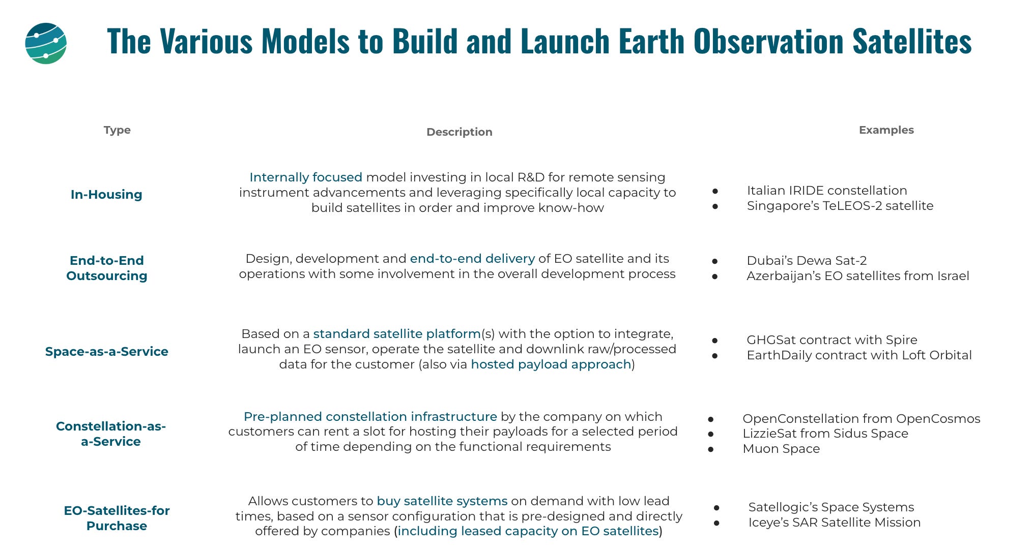
My take: As an industry, we have moved on from traditional outsourcing models for building and launching EO satellites. Here are the different ways, with some examples.
2. Strategic Stuff: Partnerships and Announcements 📈
Partnerships
- EO-based insurtech firm Floodbase has partnered with insurance firm Ag Guard to develop and distribute parametric flood insurance programs across both Australia and New Zealand;
- Even as climate risk becomes more and more uninsurable, organisations like First Street Foundation are making this EO-derived data more accessible through partnerships with large insurance firms and real-estate firms;
Announcements
- Planet has announced that it has completed ground tests with satellite communications firm SES, with an aim to offer an integrated real-time connectivity solution, with inter-satellite links for rapid data transfer;
- Maxar has announced new executive appointments, including a new CEO for its Intelligence business, which is focused on EO.
3. Interesting Stuff: More News 🗞️
- The UK’s Alan Turing Institute and the Met Office are collaborating on leveraging AI to enable improved weather forecasting;
- The World Meteorological Organization released its annual report on State of Climate Services, this year focusing on health, including the use of EO;
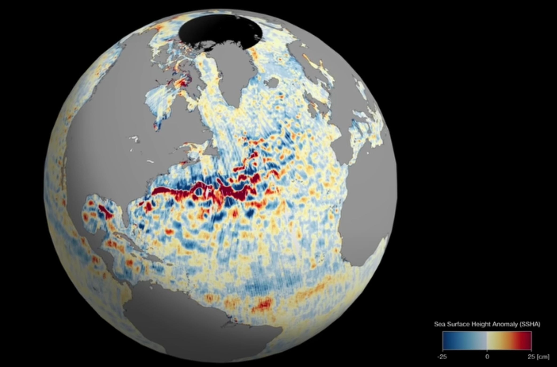
- New data on global sea levels was published, thanks to data collected from NASA’s SWOT mission, which monitors almost all of Earth’s water resources.
4. Click-Worthy Stuff: Check These Out 🔗
- This piece on TerraWatch, which discusses the importance of leveraging multiple EO data sources for solving problems and how platforms like UP42 enable their customers to do that efficiently;
- This brilliant paper that looks into the barriers and pathways to integrating satellite data in air quality monitoring, regulation and policy in the UK;
- The Copernicus Ocean State report with an overview of the state of the global oceans.
If this was forwarded to you, please subscribe to receive Earth observation insights!
One EO Discussion Point
Exclusive analysis and insights from TerraWatch
5. The EO for GHG Emission Monitoring Value Chain
While satellites and data acquired by them take much of the attention in the EO sector, the value of GHG emission data is not realised until it is used to drive action. As such, the value chain for GHG monitoring, with respect to EO, can be classified into four market segments, as shown in the figure below.
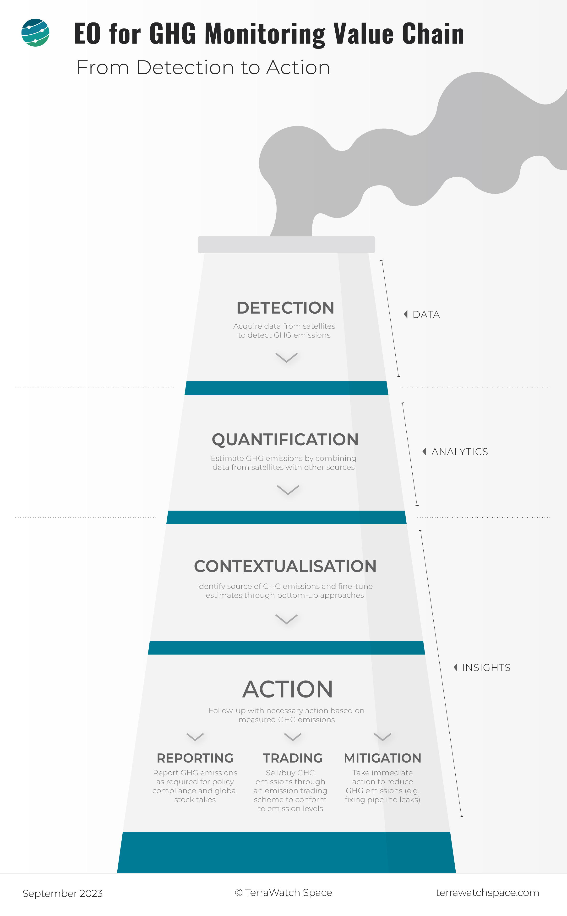
Detection, Quantification, Contextualisation and Action
Detection
This can be equated to the Data layer of EO, in which satellites play a fundamental role by measuring the GHG profiles in the atmosphere as well as identifying the corresponding emissions on the ground;
Quantification
This can be considered to be the Analytics layer, in which data acquired from satellites is translated into some form of useful information - in this case, quantified emissions, which involves combining EO emission data with data from other sources such as airborne and ground sensors;
Contextualisation and Action
These two segments can be considered to be part of the Insights layer, in which, data from satellites can be used to provide contextual intelligence.
- Contextualisation is not only an important step to help pinpoint the source of emissions, but also to provide GHG emission estimates to fine-tune the bottom-up models, which are used for long-term emission monitoring globally.
- Action involves the follow-up activities conducted following emission monitoring, such as reporting, in the context of policy compliance or global stock takes, trading, with respect to emission trading schemes available, and, mitigation, referring to immediate action for reducing emissions (e.g. immediate fixes to leaks in a gas pipeline).
If you want to learn more about the use of EO for GHG monitoring, see the organisations involved in each step above and get an understanding of the market landscape, then check out the deep dive from TerraWatch.
If you are not a paid subscriber, consider upgrading your subscription to get access to premium analysis and insights.
Scene from Space
One visual leveraging EO
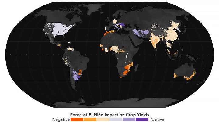
6. EO for Food Security
El Niño is disrupting weather patterns across the world resulting in positive and negative consequences for food production. The map below shows the projected impact of El Niño on key commodity crops, including wheat, maize (corn), rice, soybean, and sorghum.
The map is from NASA, developed by the Famine Early Warning Systems Network, including contributions from NASA researchers, based on an analysis of historical crop yields and climate data from 1961 to 2020
PS. What can TerraWatch Do for You?
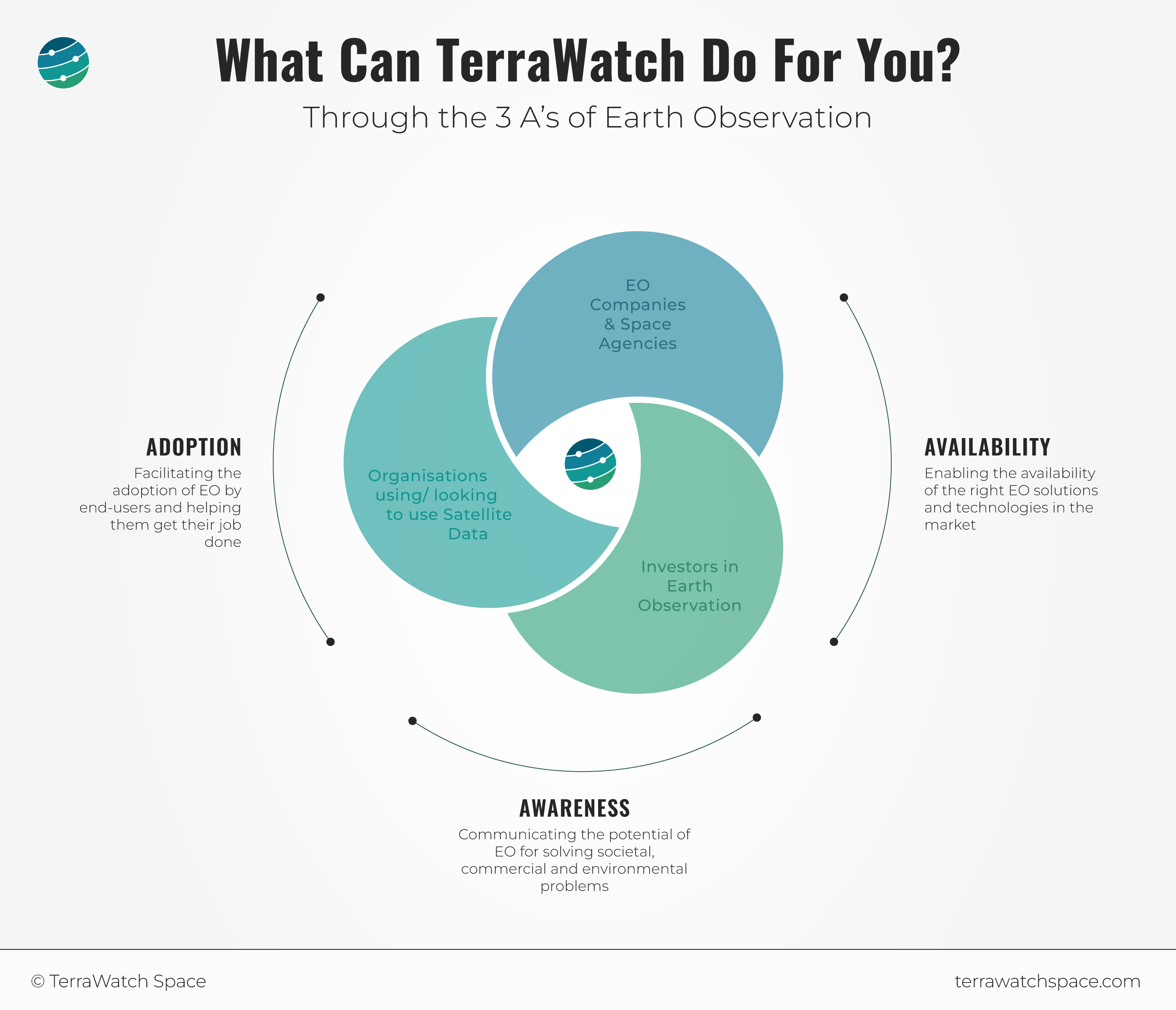
I always get asked about what TerraWatch (TW) is and what TW does. While a strategic consulting, market intelligence and communication firm in the Earth observation sector is a very functional way of describing the services offered by TW, I thought it would be better to clarify this for everyone - as always with a framework supported by an infographic, in true TW fashion.
Whether you are an EO company, space agency, investor or end-user, there is always something TW can do for you - this is shown below through the 3A’s framework, which I introduced at the beginning of this year.
If you want to learn more about the services from TW, the kind of projects we do, and the clients we have worked with, you can always check out the website - or simply, just send me a note.
Until next time,
Aravind


