

Welcome to a new edition of ‘Last Week in Earth Observation’, containing a summary of major developments in EO from last week and some exclusive analysis and insights from TerraWatch.
There was no newsletter last week, as I took a few days off, but satellites do not. So, we have got a lot to catch up on today!
In this edition: A16 cm SAR image, Chinese SAR satellites, fewer contrails with satellites, an infographic to demystify EO sensors, an EO conference and more.
Four Curated Things
Major developments in EO from the past week
1. Contractual Stuff: Funding, Contracts and Deals 💰
Funding
- SAR analytics startup Satim raised $2M in funding for advanced automatic object detection, identification and classification using SAR;
- Dutch startup Meteory which uses satellite data for environmental monitoring raised €550k in a pre-seed round;
Contracts
- Spire renewed their contract with NASA for providing multi-sensor data for the Commercial Smallsat Data Acquisition program, while Iceye received the first task order to provide SAR data;
- Open Cosmos was selected by Peru’s National Commission for Aerospace Research and Development to develop an EO data platform;
- Weather app company MyRadar, which is building a satellite constellation, received a grant from NOAA for building a wildfire monitoring system;
- British defence firm BAE is acquiring US-based Ball Aerospace, which has the credentials for being the instrument provider and manufacturer of key EO missions such as Landsat, MethaneSAT, Cloudsat, GPM etc. for $5.6B;
- Greenhouse gas monitoring satellite startup GHGSat has ordered four additional 16U cubesats from Spire to be launched in 2024;
- Scottish carbon monitoring startup Space Intelligence has been selected to map Kenya and Tanzania to be used for carbon market verification purposes;
Earnings Reports
- BlackSky reported revenues of $19.3M for Q2 2023, up 28% from the prior year period, thanks to a number of recent wins internationally;
- Spire reported revenues of $26.5M for Q2 2023, up 37% from the prior year period and expects positive cash flow by the end of 2023.
2. Strategic Stuff: Partnerships and Announcements 📈
Partnerships
- Mapfre, a Spanish insurance company has partnered with Lobelia Earth, an EO-based climate data analytics firm for providing climate risk data;
- Saudi Arabian enterprise software firm Quant is collaborating with Satellogic to explore the use of satellite data for the real estate market;
- Canadian satellite data marketplace SkyWatch is partnering with Umbra to provide integrated radar-optical satellite data on its platform;
- Agriculture market leader Cargill is working with Dutch startup Satelligence to use EO-powered deforestation risk monitoring across its supply chains;
Announcements
- Array Labs, which plans to launch a satellite constellation for building a 3D map of the planet will launch its first satellite next year;
- Planet announced plans to release its global forest carbon dataset, one of the several Planetary Variables the company has been building, and that it has closed the acquisition of Slovenian EO firm Sinergise;
- Zeus AI, a weather startup released LENS-Cast, a satellite-based, real-time weather forecast;
- Rocket Lab announced contracts to launch several EO satellites from Japanese SAR firm iQPS, NASA’s PREFIRE cubsesats and BlackSky;
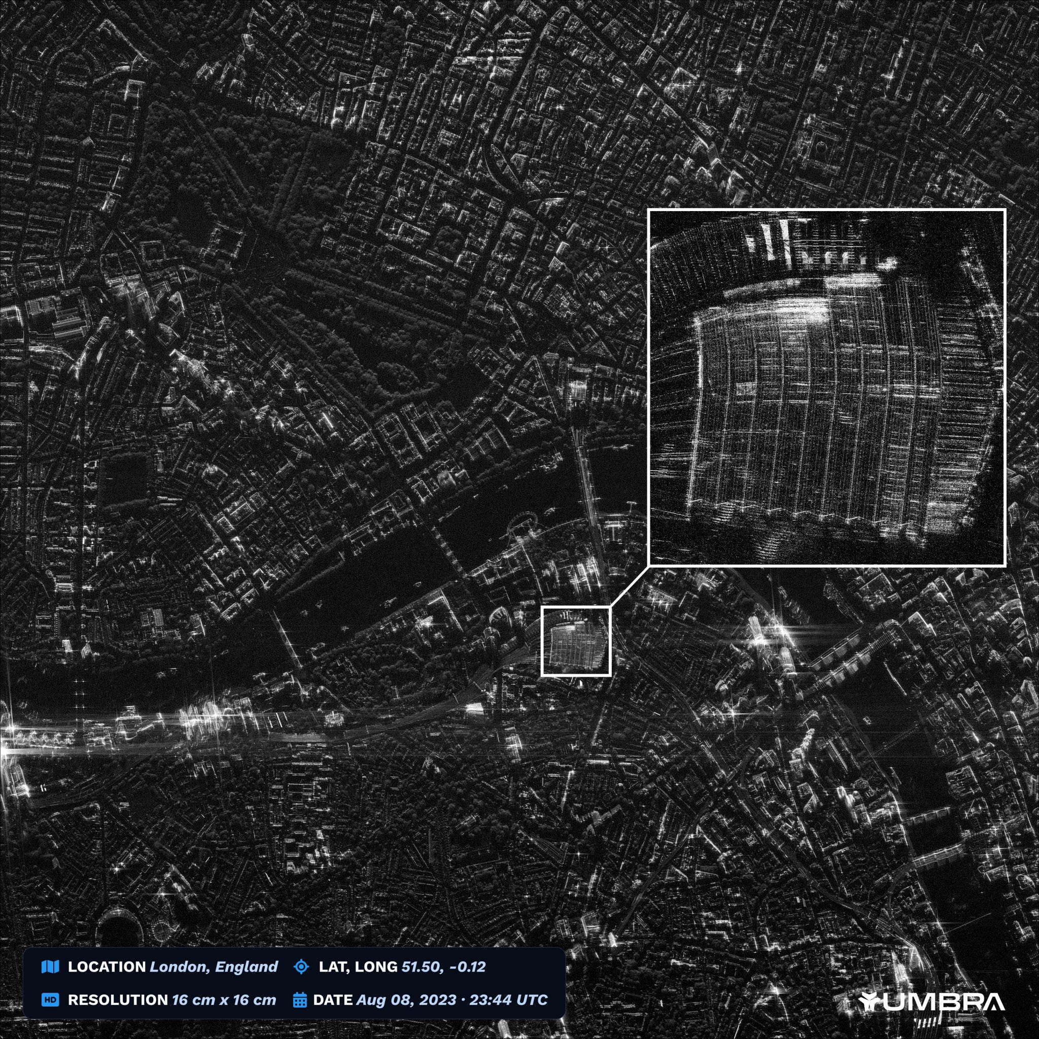
- Taking advantage of NOAA’s loosened restrictions on commercial remote sensing license conditions, Umbra released a SAR image at 16 cm (🤯) resolution (to learn more about Umbra’s secret sauce, see this thread).
3. Interesting Stuff: More News 🗞️
- The US National Reconnaissance Office is interested in selecting providers who can provide new forms of optical satellite imagery;
- India could launch over 100 EO satellites based on a public-private partnership model, according to a recent consultation report;
- Europe’s final launch of this year on a Vega will consist of multiple EO satellites including Thailand’s THEOS-2 and a Taiwanese weather satellite;
- China launched an S-band SAR satellite as well as the world’s first geostationary SAR satellite, both to be used for environmental monitoring;
- Google, in collaboration with American Airlines, used satellite imagery, weather data and other sources to demonstrate how airlines can mitigate the climate impact of contrails;
- July 2023 has been confirmed as the hottest month on record by the WMO, the Copernicus Climate Service, and NASA (see graphic below), based on historical reanalysis of data, including from satellites.

4. Click-Worthy Stuff: Check These Out 🔗
- This article that looks into whether the official flood zones in the US are out of date;
A collection of datasets, tools and resources on the Maui wildfires
This article on how AI and satellites are supporting damage assessments;
This piece ($) that dives deep into how investors are underpricing climate risks (for more on EO for climate risk, check out the exclusive deep dive);
This article that details how the EO sector is moving towards larger satellites;
My take: It might be tempting to conclude that larger satellites are better for EO than smaller satellites. But that may be overlooking the success of NASA’s TROPICS cubesats (to be commercially implemented by Tomorrow.io) and the increasing adoption of Spire’s 16U cubesats by OroraTech, GHGSat & NorthStar.
Different satellites might be suited for different purposes. As I wrote in my “unproven guide to building an EO company”, it always goes back to what business problem are we trying to solve. I have concluded that the objectives of the mission, derived from the business problem needs to lead to the configuration of the satellite and its architecture. However, many EO missions attempt to fit a square peg in a round hole rather than figuring out whether the customer wants a square peg or a round hole or something else altogether.
Subscribe for more Earth observation insights!
One Infographic
Insights from TerraWatch
5. Demystifying Earth Observation
Here is an overview of the plethora of remote sensing instruments in (or planned to be in) space - classified by type of instrument, along with some examples.
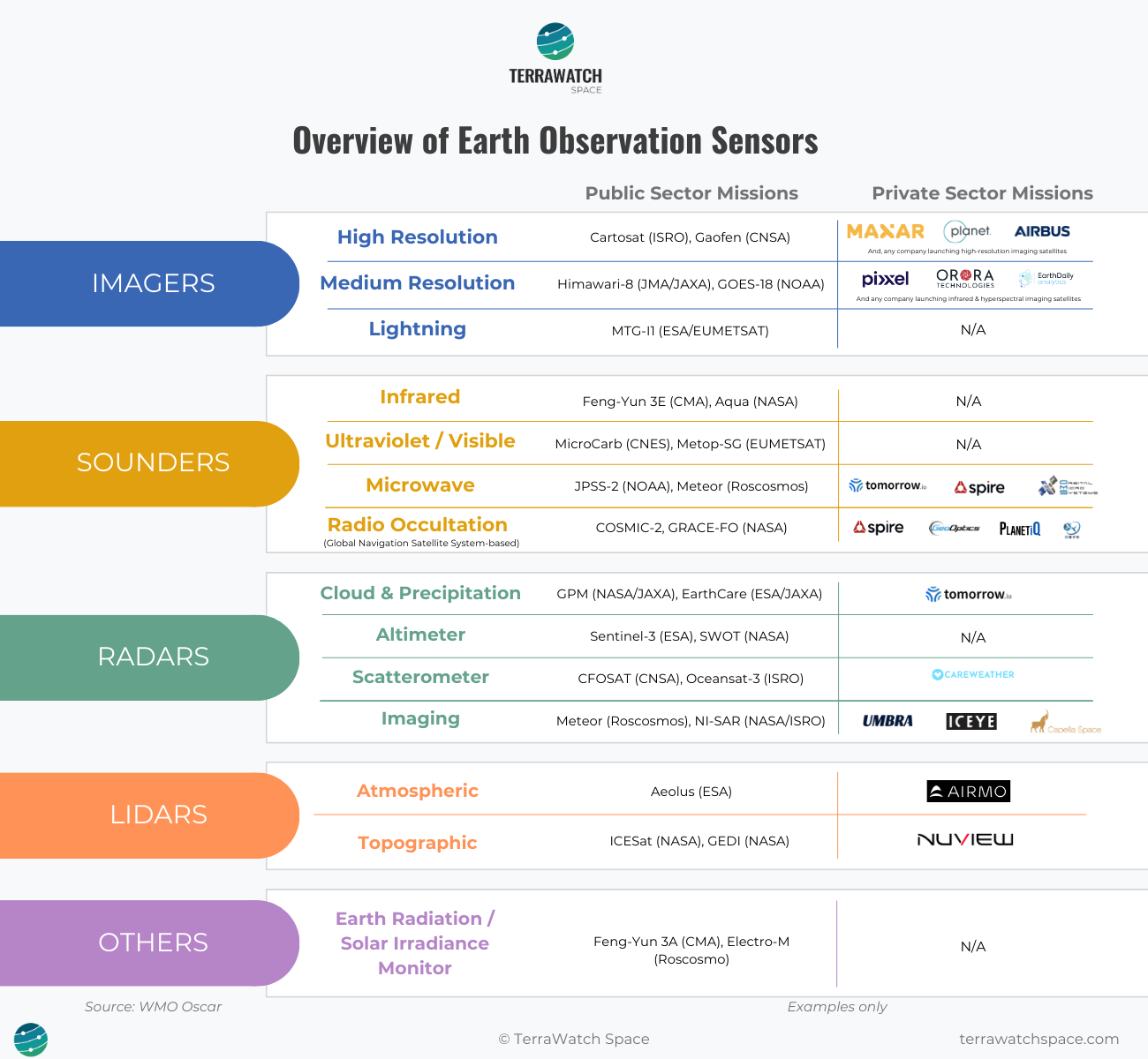
Earth observation can be daunting for an outsider (it was for me 6 years ago), but it really does not have to be. The above visual is an example of what and how you will learn EO in a course to be unveiled soon, aimed at EO enthusiasts, entrepreneurs, investors and end-users.
One Teaser
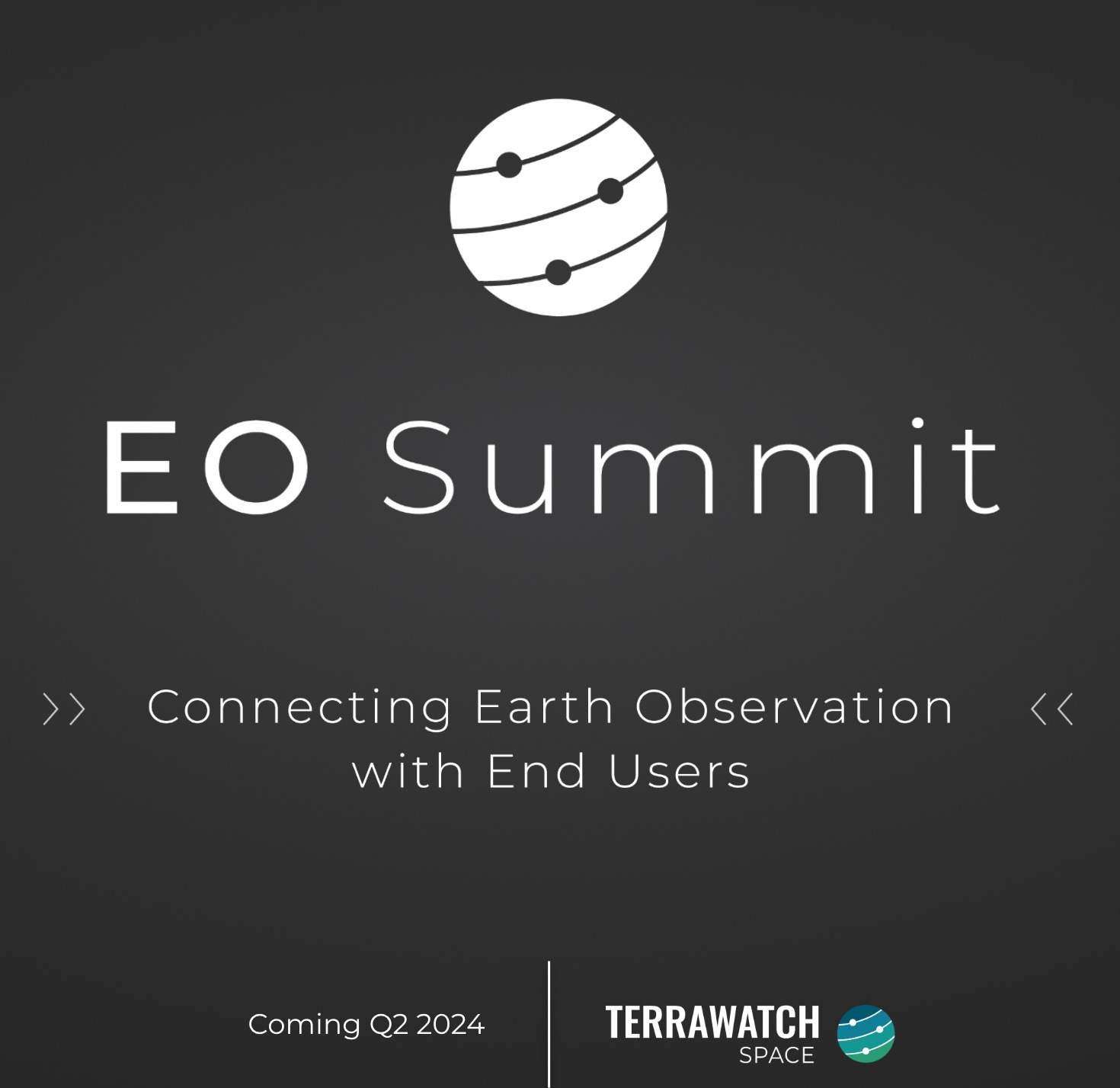
An EO Conference from TerraWatch
Almost every conference in Earth observation is “an event for those within the EO bubble”, and not really accessible for the end-users of EO.
EO Summit, from TerraWatch, focused on commercial and enterprise EO applications, will bring the EO industry together for end-users.
More details in September - if you are interested in sponsoring, send me a note!
Until next time,
Aravind


