

Hey! Welcome to a new edition of ‘Last Week in Earth Observation’, in which I attempt to curate the major developments in EO from the week that just passed and provide some thoughts & analysis on some of them.
In this edition, you can read about the several ways to launch an EO satellite and check out an interesting infographic on EO for biodiversity monitoring.
Four Curated Things
Major developments in EO from the past week
1. Contractual Stuff: Funding, Deals and More 💰
- SITAEL, an Italian small satellite manufacturer signed a contract with ESA to build four EO satellites with hyperspectral sensors as part of Italy’s IRIDE EO satellite constellation;
- 3D geospatial platform, Cesium signed a research agreement with the US National Geospatial-Intelligence Agency to explore the use of 3D data;
- Freight software platform Enqlare selected Spire to provide automatic identification system (AIS) vessel tracking data;
- LiveEO received an €800K grant from ESA to develop monitoring services for the forestry sector and insurers based on satellite data and AI;
- The shareholders of Maxar Technologies have approved the acquisition by private equity firm Advent International, for $6.4B.
2. Strategic Stuff: Announcements and Partnerships 📈
ESA launched WorldCereal, the world’s first dynamic and open-source system to provide seasonally updated cropland and crop-type maps at 10-meter spatial resolution at a global scale;
Amazon Web Services selected 14 startups for the 2023 AWS Space Accelerator including 4 EO startups:
GRASP, which aims to build and launch an EO satellite constellation with air pollution monitoring sensors;
Kawa Space, a geospatial intelligence startup;
Little Place Labs, an edge computing startup;
Lunasonde, which aims to launch an EO satellite constellation with radars for subsurface imaging of the Earth, the Moon and beyond;
Climate Engine launched SpatiaFi, a platform to provide private and public sector organizations insights into climate risks on Google Cloud;
EO platform startup SkyWatch is partnering with Urban Sky, a stratospheric balloon imaging startup to distribute their imagery through SkyWatch's data management and distribution platform, TerraStream;
Another EO platform startup Astraea launched satellite tasking capabilities allowing tasking of satellite imagery from providers like Planet;
The Government of India approved the country’s national space policy, which contains the following two critical points related to EO, among others:
“… enable open data access from remote sensing satellites of ISRO. In this regard, remote sensing data of GSD of 5 meters and higher shall be made easily accessible in a timely manner on ‘free and open’ basis to all while remote sensing data of GSD of less than 5 meters, shall be made available free of any charges to Government entities but at fair and transparent pricing to NGEs.”
“.. make available archived satellite data and satellite-derived thematic data from remote sensing satellites of ISRO on ‘free and open’ basis for further value addition and for research and development purposes on ‘as is where is’ condition. The details of the archived remote sensing data in terms of resolution, latency etc., will be made known in the public domain time-to-time.”
3. Interesting Stuff: More News 🗞️
- ESA’s Aeolus satellite, (one of my favourite EO birds) which monitors atmospheric winds with a LiDAR sensor is about to complete its mission;
- NASA launched a new project called OPERA (Observational Products for End-Users from Remote Sensing Analysis) to provide data from multiple satellites for use by government agencies;
- The EO industry is successfully responding to the needs of the intelligence community by offering data from various sensors, as the US National Reconnaissance Office set its eyes on emerging optical imaging capabilities;
Some launch news…
- ISRO launched an EO satellite equipped with a SAR instrument, called TeLEOS-2 for Singapore;
- China launched an advanced EO satellite, called Fengyun 3G, with precipitation radar among other instruments;
- Leonardo DRS launched a thermal imaging radiometer with Loft Orbital to measure the Earth’s surface temperature from space;
In other news …
- Apple announced an expansion of Restore Fund, its nature-based carbon removal initiative, the impact of which will be measured and monitored by EO - from providers such as Space Intelligence, Upstream Tech and Maxar;
- The European Parliament has approved a new regulation that would ban goods linked to deforestation (EO would play a part in that verification);
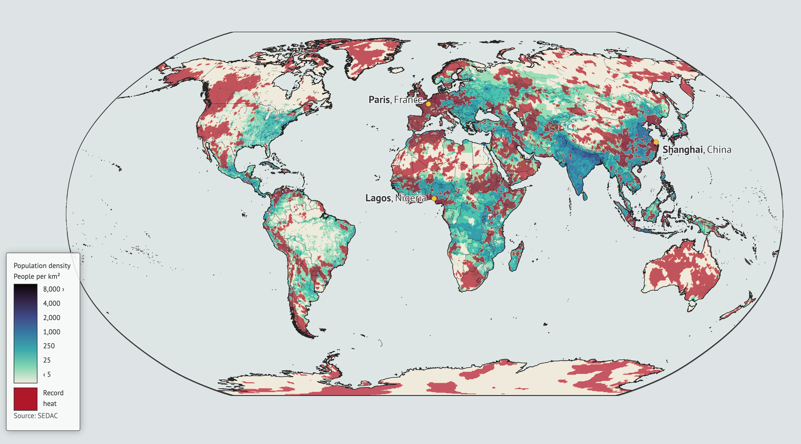
- Carbon Brief published some interesting analysis on how much the world’s most populous regions have been affected (hint: a lot!) by extreme heat since 2013, based on data from various sources including in-situ and satellites.
4. Click-Worthy Stuff: Check These Out 🔗
- This briefing session from ESA Climate on the agency’s new climate programme (scheduled on May 10);
- This piece, which summarises this paper on the climate and ozone impacts of global rocket launches;
- This timelapse collection on Google Earth Engine for you to see how major places on our planet have changed since 1984 (belated Earth Day wishes!);
- This piece that showcases how a satellite signal failure brought farms across Australia and New Zealand to a halt;
- This competition from XPRIZE focused on wildfire monitoring including $5M for a space-based wildfire detection challenge;
- This paper from Meta showing how a combination of high-resolution optical satellite imagery combined with aerial LiDAR and GEDI mission data can be used to map and validate forest canopy height at an individual tree level.
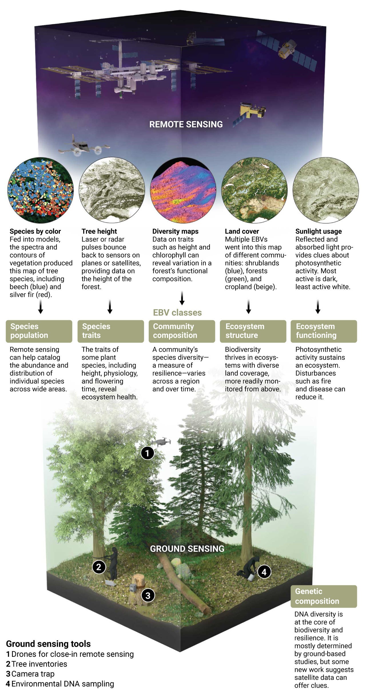
- This piece (from 2021) that provides a good overview of the use of remote sensing for biodiversity monitoring (summarised in the infographic below)
Subscribe to receive Earth observation insights!
One Discussion Point
Analysis, thoughts, and insights on developments in EO
5. Earth Observation Made Easy? The Many Ways to Launch an EO Satellite
Is it just me or have you noticed an uptick in the number of EO satellites recently? InnerPlant, an agtech firm is co-designing and launching a satellite through Satellogic. In the SpaceX Transporter-7 mission that launched recently, there were quite a few of them (which I wrote about).
Some notable examples on the mission: Kenya’s first private EO satellite Taifa-1, Dubai’s Dewa Sat-2, the first EO satellite by any national utility firm, Saudi Arabia’s KAUST CubeSat, the first on-orbit demonstration of GNSS-Reflectometry and hyperspectral sensors and Turkey’s IMECE, the first indigenously built EO satellite from Turkey.
As I zoom out and process the influx of EO satellite missions, I see six types of models emerging in the EO satellite system segment, along with some recent examples of them:
The traditional in-housing model focused on internal R&D along with indigenous manufacturing to invest in local capacity and skills:
Examples: Contracts for the Italian IRIDE constellation, Singapore’s TeLEOS-2 satellite;
The traditional outsourcing model with end-to-end delivery of the satellite and its operations with some level of local involvement in the process:
Examples: Dubai’s Dewa Sat-2;
The emerging space-as-a-service model (or in some cases, a variation of the hosted payload approach) on a standard platform with the ability to integrate, launch a sensor and operate the satellite for the customer:
The emerging constellation-as-a-service model based on a pre-planned constellation infrastructure on which customers can bring and integrate their payloads:
Examples: OpenConstellation from OpenCosmos, LizzieSat from Sidus Space etc;
The bespoke EO satellite model that focuses on building custom EO satellite systems based on the problem statement centred around a thesis, instead of offering a standard platform model:
Example: Muon Space;
The EO-satellites-for-purchase model allowing customers to acquire satellite systems on demand with low lead times, based on a sensor configuration designed and offered by the EO companies (I also consider leasing EO satellite capacity a variation of this approach).
Examples: Satellogic’s Space Systems, Iceye’s SAR Satellite Mission, AAC Clyde Space’s EPIC VIEW satellite etc.
As it becomes easier to design, manufacture and launch EO satellites, the number of options to get an EO satellite to orbit has also increased. If you are an organisation that is interested in launching your own EO satellite for a commercial, geopolitical, or any other reason, you have got quite a headscratcher!
One Podcast Episode
From the TerraWatch Space podcast
6. How to Build an Effective EO Adoption Strategy?
If you are curious about how a market leader in infrastructure monitoring and surveying uses EO and builds an effective and sustainable in-house geospatial data strategy for their solutions, then this episode is for you. Conversations with end-users are always a reality check for the EO industry and this was a very insightful one.
In the latest episode of the podcast, I speak to Pooja Mahapatra from Fugro to discuss what the company does, why EO is one of the many tools in their 'toolbox', how to build an effective EO adoption strategy and more. Check it out!
📧 Something missing? Just hit reply to send me any news, announcements, interesting pieces or any EO-related content that you want to feature here.
Until next time,
Aravind


