

Welcome to a new edition of ‘Last Week in Earth Observation’, containing a summary of major developments in EO from last week and some exclusive analysis and insights from TerraWatch.
In this edition: Edge computing, methane detection, Antarctic sea ice levels and penguins, demystifying the process of converting EO data into insights and more
Four Curated Things
Major developments in EO from the past week
1. Contractual Stuff: Funding, Contracts and Deals 💰
- Planet won a new contract (with a seven-figure annual contract value) from a Ministry of Foreign Affairs in Asia for its global daily monitoring solution, and closed its acquisition of Slovenian EO firm, Sinergise (+ my thoughts);
- SAR satellite firm Umbra was selected by the US Air Force for a contract worth $1.25M to demonstrate the tracking of moving targets with its data;
- Iceye announced that, through a partnership with PAR Technology Corporation, it is one of the 16 vendors selected by the US Space Force for a low Earth orbit satellite services contract worth $900M;
- The UK Space Agency awarded grant funding (roughly worth £50K each) to ten projects that use EO data to develop commercial solutions;
- Satellite manufacturing firm Sidus Space which plans to launch multi-sensor EO satellites, has acquired edge computing firm Exo-Space.
My take: Any company that is launching new EO satellites will have to inevitably include edge computing (aka on-orbit data processing) into their plans - not only because of the technological progress in the domain, but also because of the operational efficiency and user experience edge computing promises to offer.
So, being a new entrant in the already-crowded EO market, Sidus Space needed to differentiate itself. This acquisition allows Sidus to not only offer multi-sensor data, but also along with on-orbit computing capabilities. For more on edge computing, stay tuned for the exclusive deep-dive this week!
2. Strategic Stuff: Partnerships and Announcements 📈
Microsoft is partnering with Accenture to provide methane emissions management services by integrating EO data along with other sources;
Deloitte announced a new initiative with Google Cloud to leverage Google Earth Engine for integrating geospatial analytics into its services;
French EO platform startup SpaceSense announced that agtech startup Eiwa has integrated SpaceSense’s geospatial processing tools;
Hyperspectral satellite startup Orbital Sidekick unveiled the first set of insights from recently launched satellites, demonstrating its methane plume detection capabilities.
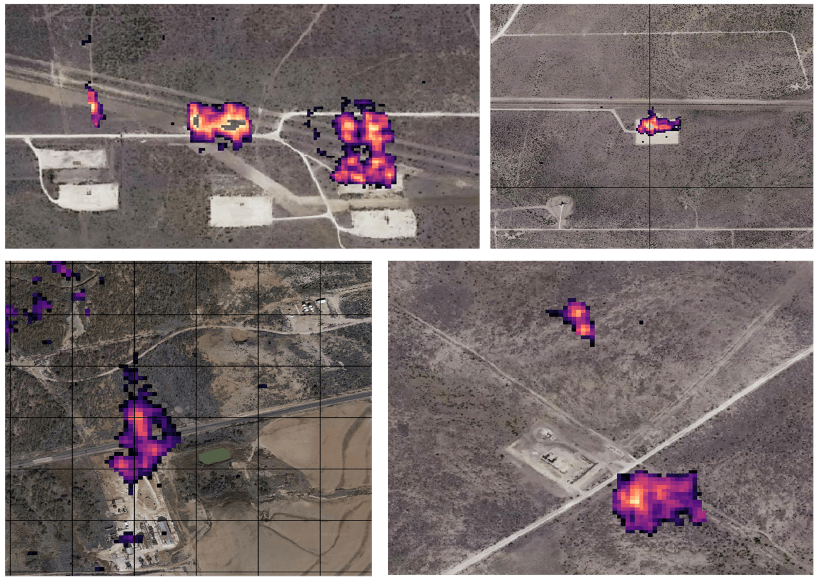
Credit: Orbital Sidekick
3. Interesting Stuff: More News 🗞️
The US Office of the Director of National Intelligence plans to investigate the lagging procurement of commercial satellite data;
Methane emissions from the manufacturing facilities of Blue Origin were spotted by the EMIT sensor onboard the International Space Station;
The Hong Kong University of Science and Technology plans to launch a multi-spectral optical satellite to be used for environmental monitoring;
NASA shared the first images from the recently launched pollution-monitoring sensor that will measure quality over North America, with a resolution of a few square miles.
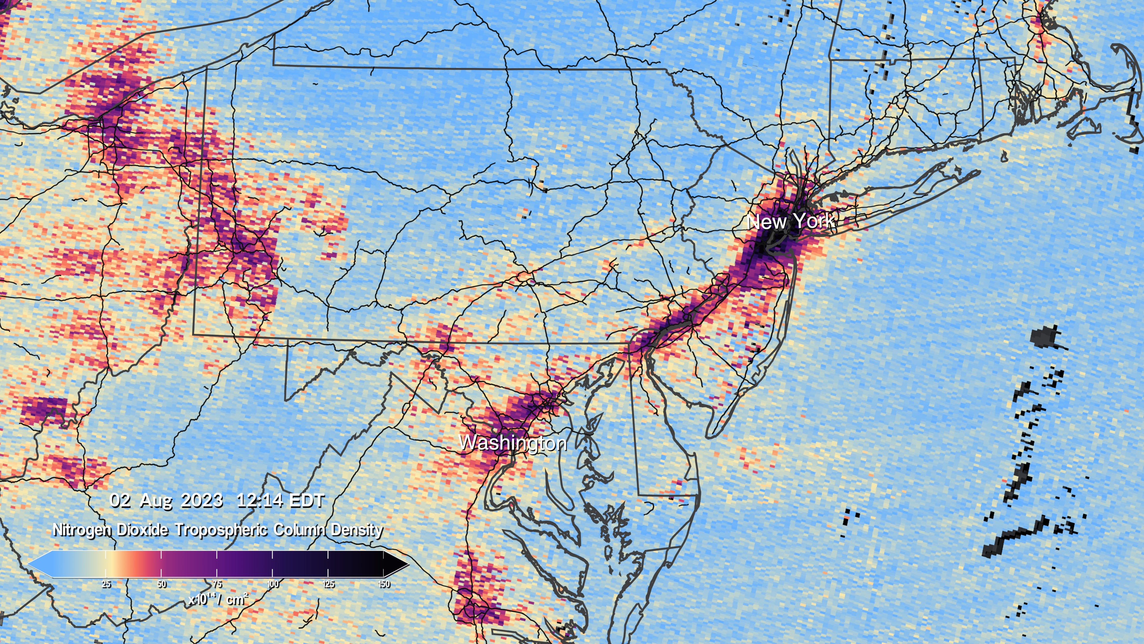
Credit: NASA
4. Click-Worthy Stuff: Check These Out 🔗
This video for a primer on what satellite imagery is and how it works;
This piece that dives into how EO data was used to understand how over 10,000 penguin chicks died due to low sea ice levels in Antarctica.
If you want to dive deeper, check out the full study.
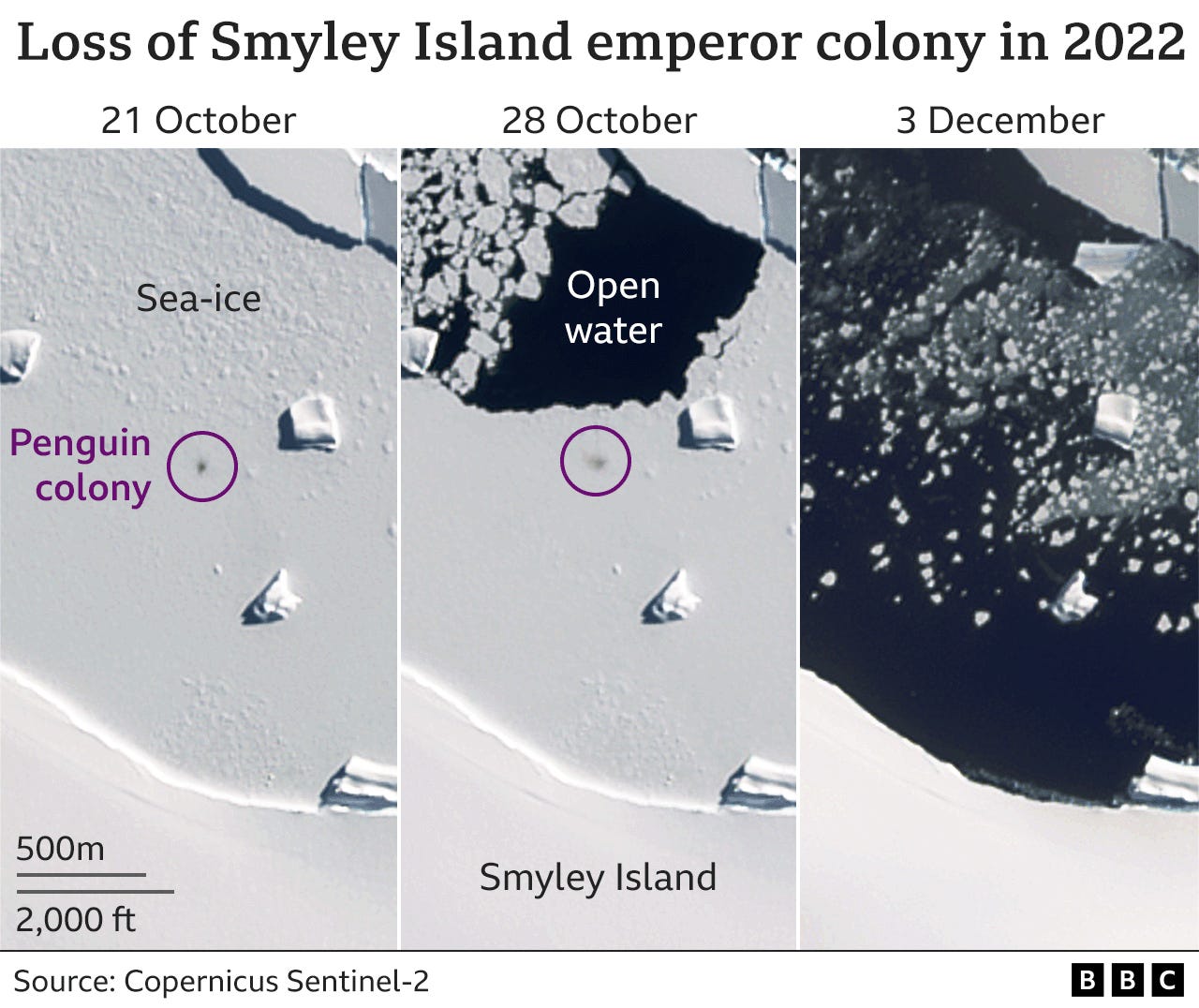
Credit: BBC
Subscriber for Earth observation insights!
One Discussion Point
Analysis, thoughts, and insights on developments in EO
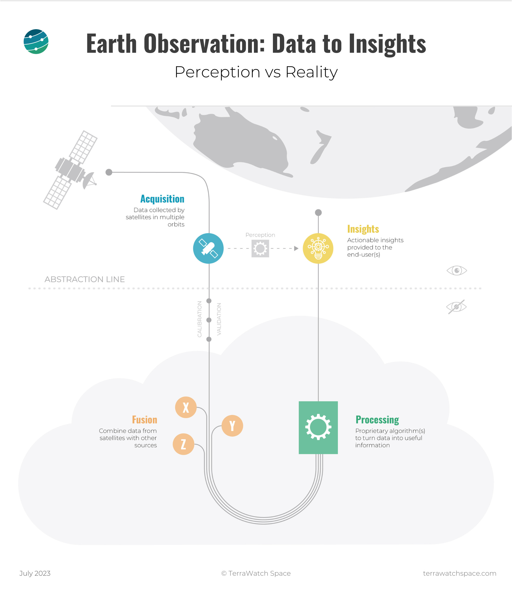
5. Demystifying the Process of Converting EO Data into Insights
As EO continues to increasingly enable impactful societal, economic and environmental decisions, it becomes increasingly important to understand what goes on behind the hood. The figure below is an attempt to demystify the process of translating EO data into insight.
Yes, some end-users of EO do not really care about how the insights are derived, but commercial EO-derived products are increasingly being used to make crucial decisions such as individuals deciding where to buy property, organisations identifying the climate risk for their assets, governments monitoring the level of wildfire threat for a region etc.
As the commercial EO industry continues to grow and increasingly plays a part in our lives, it might be a good time to start talking about the “black-box problem” in EO, especially as EO-based commercial applications become a fundamental part of the lives of individuals, businesses and governments.
As much as we focus on the role of commercial EO in offering insights to solve a specific market problem, it is equally, if not more, important to be able to fully understand how the insights were derived. Whether it is through continued peer-reviewed publications, complete transparency through an open-source model or simply letting the market decide, that remains to be seen.
Scene from Space
One visual leveraging EO
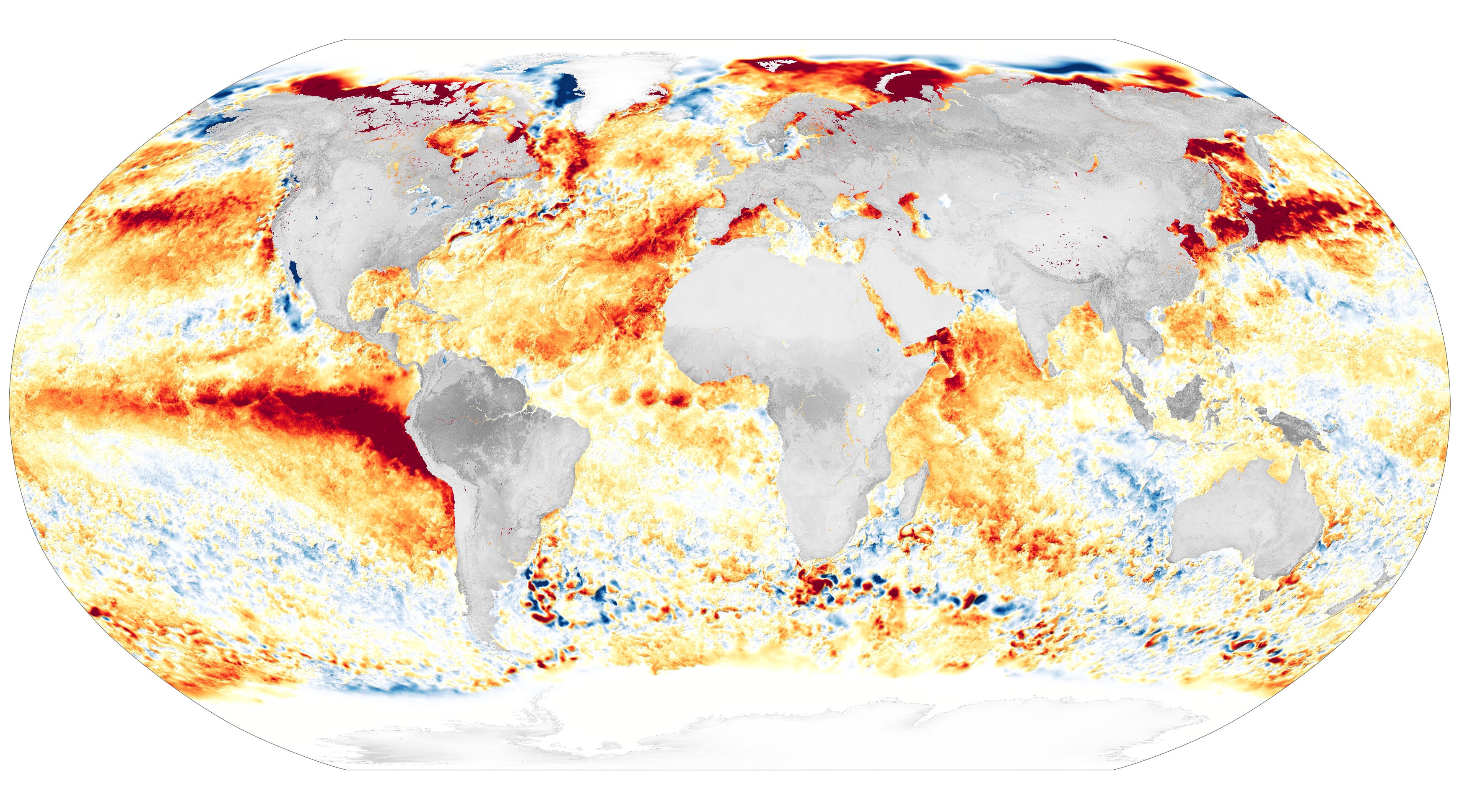
6. Marine Heat Waves
The figure below from NASA shows sea surface temperature anomalies as of August 21, 2023, when many areas of the oceans were more than 3°C (5.4°F) warmer than normal. It is derived from measurements of sea surface temperatures from multiple NASA, NOAA, and international satellites, as well as ship and buoy observations.
The average sea surface temperatures around the globe have recorded the highest levels since record keeping began. Scientists have identifed two main factors driving the records: El Niño developing in the Pacific and long-term global warming that has been pushing ocean temperatures steadily upward almost everywhere for a century.
Until next time,
Aravind.


