

Welcome to another edition of ‘Last Week in Earth Observation’, containing a summary of major developments in EO from last week and some exclusive analysis and insights from TerraWatch.
In this edition: Satellite data for emissions, air pollution from space and sponsors for EO Summit
Four Curated Things
Major developments in EO from the past week
1. Contractual Stuff: Funding, Contracts and Deals 💰
Funding
- Amini, a Kenya-based startup building an EO data aggregation platform to bridge the environmental data gap in Africa, has raised $4M in seed funding;
Contracts
- TomorrowNow, a weather non-profit won a $5M grant from the Bill and Melinda Gates Foundation to provide weather and climate services in Africa.
2. Strategic Stuff: Partnerships and Announcements 📈
Partnerships
- India’s Tata Advanced Systems and EO firm Satellogic signed a strategic partnership to build EO satellites in India, enabling technology transfer and local capacity building for optical sub-meter resolution EO satellites;
- EO platform SkyFi integrated data from Urban Sky, a stratospheric ballooning firm, IMPRO, a Turkish satellite imaging firm and open SAR data from Umbra;
- EO platform UP42 has partnered with OroraTech integrating thermal infrared data from OraTech available on UP42’s marketplace;
Announcements
Spire announced the launch of its high-resolution weather forecast model, leveraging proprietary data from its radio-occultation-sensor-equipped satellites, for the energy and commodity markets.
Want to understand the landscape of weather monitoring from space? Then, check out this free-to-access, deep-dive from TerraWatch.
Greenhouse gas emission monitoring satellite firm GHGSat announced plans to measure methane and carbon dioxide emissions at every major industrial site worldwide, every day, by 2026;
What is the state of EO for emissions monitoring? Read this subscriber-only, exclusive deep-dive on EO for GHG emissions from TerraWatch.
French environmental and energy analytics firm Kayrros launched a free version of its global methane tracker, leveraging data from the Sentinel-5P satellite and a sensor on the International Space Station;
Satellite infrastructure firm Loft Orbital launched ‘virtual missions’, an abstraction layer between satellites and data, allowing developers to deploy their software application onto a Loft satellite, leveraging onboard sensors.
My take: Virtualizing space and completely abstracting the concept of satellites away from the users has been an engineering dream - so this announcement from Loft Orbital, expected to be demonstrated with the launch early next year, is certainly a huge technical milestone.
While it does feel like we have another innovative way to use data from satellites and process it on-board to downlink analytics directly, we are not quite sure who it is for, why it is needed and how it will be used. Loft says that demand is so high that it is considering launching a constellation of ‘virtual mission’ satellites, but I wonder about the reliability1, usability2, and affordability3 of this approach for end-users.I am a huge fan of satellite-based edge computing, but after a lot of research in this area together with end-users, I have concluded that we are overestimating the potential of edge computing for the users and underestimating the type of boring problems that need to be solved to make edge computing work, more than just as a pilot project.
PS. If you want to learn more about edge computing, its applications, its limitations and the overall landscape, read my exclusive deep-dive.
3. Interesting Stuff: More News 🗞️
- Climate TRACE, a non-profit published an inventory of asset-level GHG emissions from around the world;
- The US announced rules to reduce methane emissions by 80% from the oil and gas sector and released a new Greenhouse Gas Monitoring strategy, both of which will leverage data from satellites;
- Europe’s meteorological satellite agency, EUMETSAT will cooperate with African, Indian and European weather organisations and continue purchasing data from the commercial sector - more specifically, Spire;
- Space logistics firm D-Orbit, launching on SpaceX, deployed several satellites including the first EO satellite of the Canary Islands, equipped with a multispectral sensor and an optical communications terminal;
- IBM and NASA are building an AI foundation model for weather and climate applications intending to improve speed, accuracy, and accessibility;
- Norway’s International Climate and Forest Initiative and the Bezos Earth Fund are joining forces to continue to provide access to high-resolution satellite imagery of the tropics, with data from Planet, Airbus and KSAT;
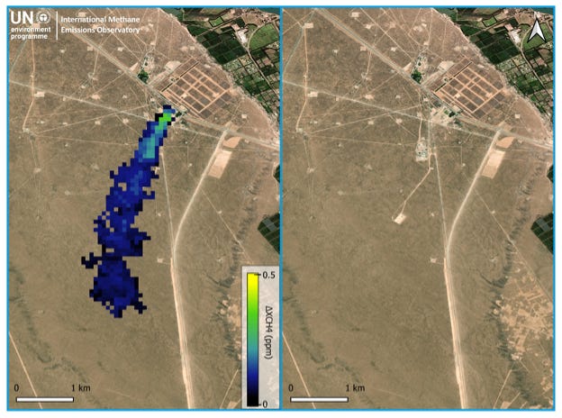
- Data from satellites, acquired and validated by the UN’s International Methane Emissions Observatory, led to a successful and confirmed mitigation of a methane leak in Argentina.
4. Click-Worthy Stuff: Check These Out 🔗
This article on space for climate for which I was interviewed for;
I had a few things to say about EO for climate and the need for increased collaboration to address data inequality in the Global South;
The geospatial strategy from the United States Agency for International Development (USAID) which discusses the potential of EO for development;
This piece that shows how companies are pushing back on analysis derived from satellite data showing their pollution;
I have written about the ‘black-box problem’, or the need to verify and validate results from EO in the past, arguing for more conversation and authority on making EO not only accessible but also credible;
This analysis that uses data from multiple sensors and companies to show how forbidden Russian oil flows into the US Pentagon’s supply chain;
This interview ($) with an Airbus EO executive containing some refreshing comments on the slow growth of the commercial EO market, radically different from the typically used, market forecast figures;
It is always good to acknowledge that reality is different from hype, presented in market reports. Market forecasts are quite useless, without creating a strategy and identifying the necessary conditions required to attain those figures - this is why I founded TerraWatch Space.
Please consider upgrading your subscription to TerraWatch, if you find this valuable.
One EO Discussion Point
Exclusive analysis and insights from TerraWatch
5. Earth Observation for Climate
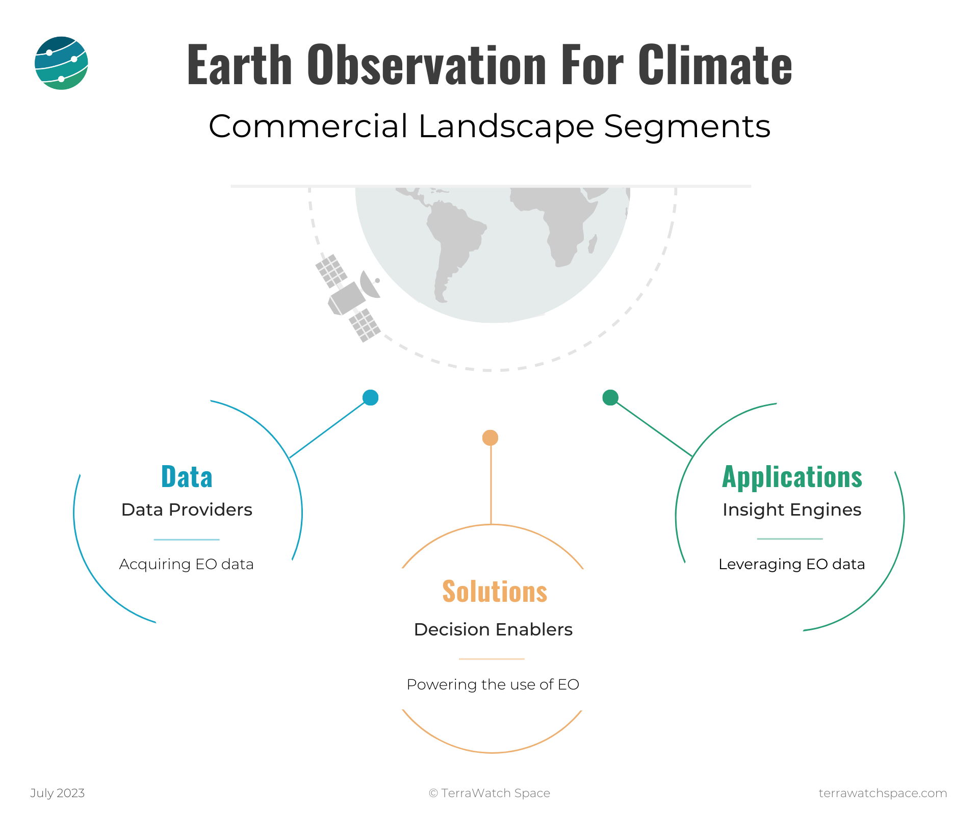
As COP28 continues in Dubai, I wanted to take the opportunity to re-share a few infographics from the free, EO for Climate deep dive, that was published earlier this year on TerraWatch. This is really for anyone who wants to get an understanding of the EO commercial market, the applications of EO for climate, how the market is organised, the market landscape and where it is heading.
The commercial landscape of EO for climate can be classified into three major segments: Climate Data, Climate Solutions and Climate Applications.
- Data is usually associated with the space industry - whether it is designing a remote sensing instrument to acquire a specific type of data, or launching it on a satellite and downlinking the data to the ground;
- Solutions are tools to empower users of EO to create their own applications, by making EO data accessible, (through data marketplaces), fusable (through interactive platforms) and usable (through ready-made analytics);
- Applications are many, growing by the day are hard to track simply due to the sheer potential of satellite data when combined with aerial, drone, in-situ and other forms of data.
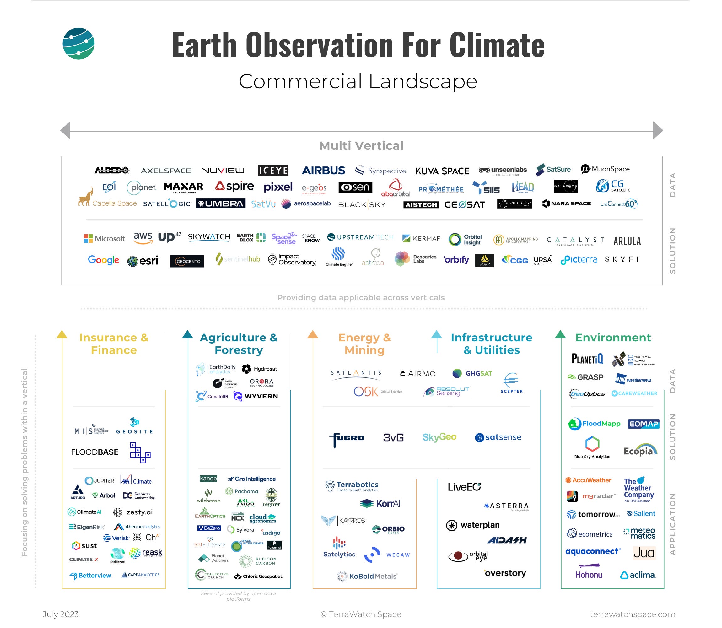
The following figure contains a non-exhaustive list of companies from the global EO market and shows a snapshot of the commercial landscape visually classified into those that are multi-vertical vs those that are verticalised. Note that, in general, companies tend to typically operate in more than one segment and more than one vertical.
Scene from Space
One visual leveraging EO
6. Air Pollution from Space
The 2023 Cricket World Cup that took place in India concluded recently - the hosts (sadly) lost to Australia in the finals. However, some of the games took place in severe conditions so much so that Reuters wrote an entire piece about it.

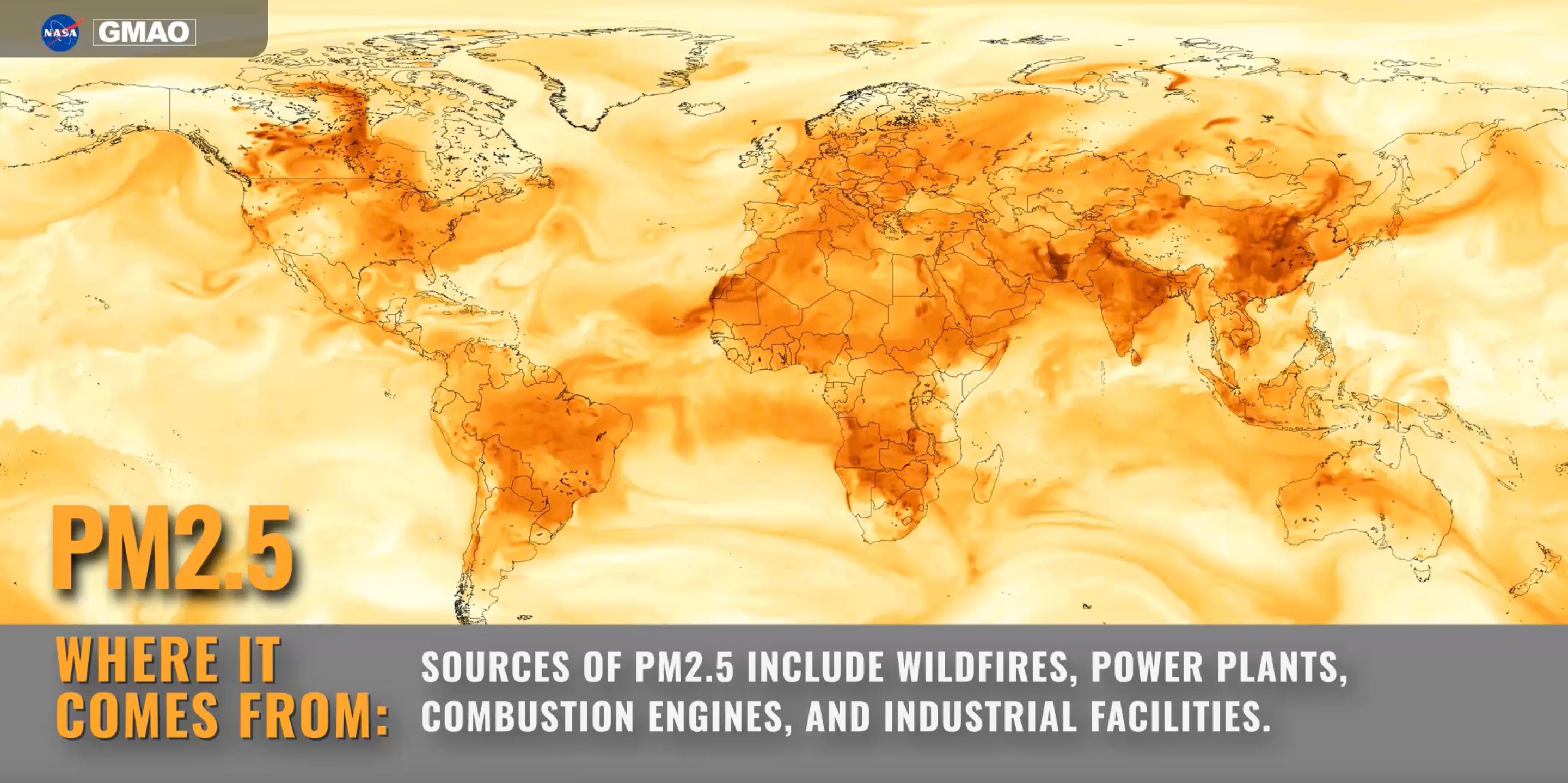
Air pollution kills almost 7 million every year. You may have seen the rankings of ‘most polluted city’ in the world, but researchers think that this is misleading as many cities and countries in the world do not have ground sensors to measure air quality levels.
A team of NASA-funded researchers is now trying to address the data shortage by developing a different way of tracking air pollution, powered by satellite data, machine learning-based modelling, and supercomputing.
Become a Sponsor for EO Summit
Recently, I announced the official launch of the first-ever edition of EO Summit, a conference to bring the EO industry and end-users together, focused on commercial, enterprise and climate-related applications of EO.
The official website will be released this week and a limited number of early bird tickets will open for sale shortly.
In the meantime, we are looking for sponsors for the event. Contact me to learn more about the sponsorship options, speaking opportunities and more.
Are you an EO company interested in showcasing your solution to end-users?

Can the analytics be calibrated and validated with the level of trust and transparency needed to make the result reliable? ↩
Is data provided in a manner that is usable to end-users, as does it just increase the amount of work needed to get the job done? ↩
How much are end-users willing to pay for this in comparison with other means to get the job done? This includes relative to doing EO the traditional way i.e. on the ground with an unmatched level of data exploration, process iteration and result verification. ↩


