

Welcome to a new edition of ‘Last Week in Earth Observation’, containing a summary of major developments in EO from last week and some analysis on the sector I have come to love.
In this edition: EO for climate risk, global heat resilience service, Antarctic sea-ice levels, monitoring irrigation with satellite data and more.
Four Curated Things
Major developments in EO from the past week
1. Contractual Stuff: Funding, Contracts and Deals 💰
- Carbon monitoring startup Sylvera, which uses remote sensing data among other sources, has raised $57M in Series B funding;
- Google, together with Woodwell Climate Research Center, has won a $5M grant to create satellite-based analysis methods for permafrost monitoring in the Arctic, leveraging data from public and commercial sources;
- Hyperspectral satellite startup Pixxel won a grant from the Ministry of Defence to manufacture miniaturized multi-payload (optical, SAR, infrared, hyperspectral) satellites for the Indian Air Force;
- Spire won a €16M contract from ESA to demonstrate a civil aviation tracking constellation that would not rely on any global navigation satellite system;
- Luxembourg-based radio frequency monitoring startup Kleos Space has filed for bankruptcy, due to launch delays, satellite development issues, and challenges with accessing capital.
My take: Radio-frequency monitoring is a tricky segment of EO, mainly because of its complementary nature compared to other EO sensors, meaning it can service very few use cases on its own. Unlike its competitors Aurora Insight, which partnered with Maxar (and later got acquired), HawkEye360, which has several ongoing international defense and civilian contracts, and Unseenlabs, which owns the European market, Kleos was left with very little share of the pie.
2. Strategic Stuff: Partnerships and Announcements 📈
- SatSure is partnering with Rabo Partnerships, an initiative of the Dutch agribusiness bank, Rabobank, to enable cash flow-based lending for smallholder farmers globally using SatSure’s EO products;
- The Group on Earth Observations announced the development of Global Heat Resilience Service that aims to provide every urban area in the world with intelligence on the health risks from exposure to extreme heat using EO;
- SAR startup Capella Space announced details about its next-generation SAR satellite including high-resolution imagery and low latency delivery;
- Another SAR startup Umbra, which announced its open data policy earlier in the year, said it has now released over $1M worth of free data;
- Spire rolled out a new weather monitoring and alerting platform, called DeepVision aimed at the energy, supply chain and logistics industries;
- EO services firm Development Seed announced the launch of eoAPI, a cloud-native, open geospatial data infrastructure to make archived EO data more easily discoverable and interoperable.
3. Interesting Stuff: More News 🗞️
- India launched 7 Singaporean satellites, including a SAR satellite to be used by Singapore government agencies and commercial customers;
- The US Environmental Protection Agency and the Department of Energy will provide more than $1B in funding to reduce methane emissions from the oil and gas sector, which includes tools to monitor methane emissions;
- ISRO published details of the NISAR Utilization Programme, an initiative to allow Indian researchers to access data from the NISAR satellite with a dual-frequency S-and L-band SAR instrument, launching in early 2024;
- ESA’s global wind monitoring Aeolus satellite safely re-entered the atmosphere in a pioneering effort from the agency to demonstrate end-of-life procedures, bringing the trailblazing, impactful mission to an end.
4. Click-Worthy Stuff: Check These Out 🔗
- This piece that highlights how the Surface Water and Ocean Topography (SWOT) mission, by NASA and CNES, will provide insights into Earth’s water;
- This piece that dives into the future of weather forecasting, which will inevitably be supported by commercial EO missions;
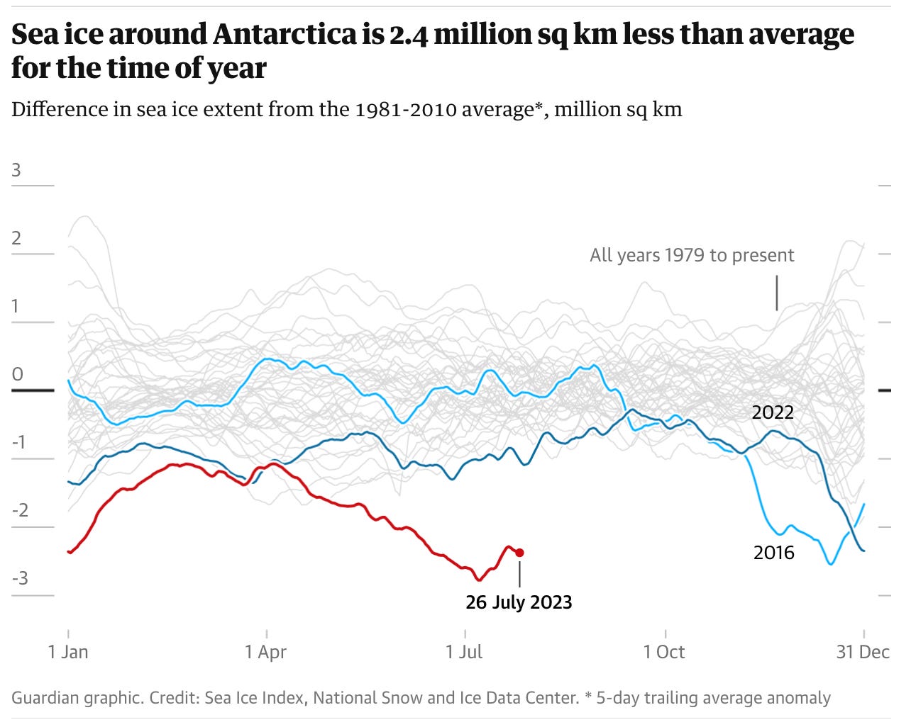
- This piece that digs into why the Antarctic sea ice levels are so low.
Subscribe to receive Earth observation insights!
One Discussion Point
Analysis, thoughts, and insights on developments in EO
5. Earth Observation for Climate Risk
In case you missed it, the first exclusive deep dive for paid subscribers dropped yesterday, and it is about EO for climate risk.
If you are a paid subscriber, you can read the full piece which includes: an introduction to climate risk, the types of risks, the importance of EO, an overview of the landscape for measuring, reporting and responding to climate risks and some examples of climate risk in use.
If you are a free subscriber, you can read a short preview of the piece. Please consider becoming a subscriber if you want to get access to exclusive content and support my work. Use this link to subscribe and get a 20% discount today!
Climate Risks and the Relevance of EO
In the piece, I discussed the different types of climate risks, the role of EO in helping collect data to understand the status quo as well as the time series reanalysis, that satellites enable. There are several open-source and proprietary tools in the market for organisations to start analysing the risks to their assets, for most, if not all, of these risks, as a result of anthropogenic climate change.
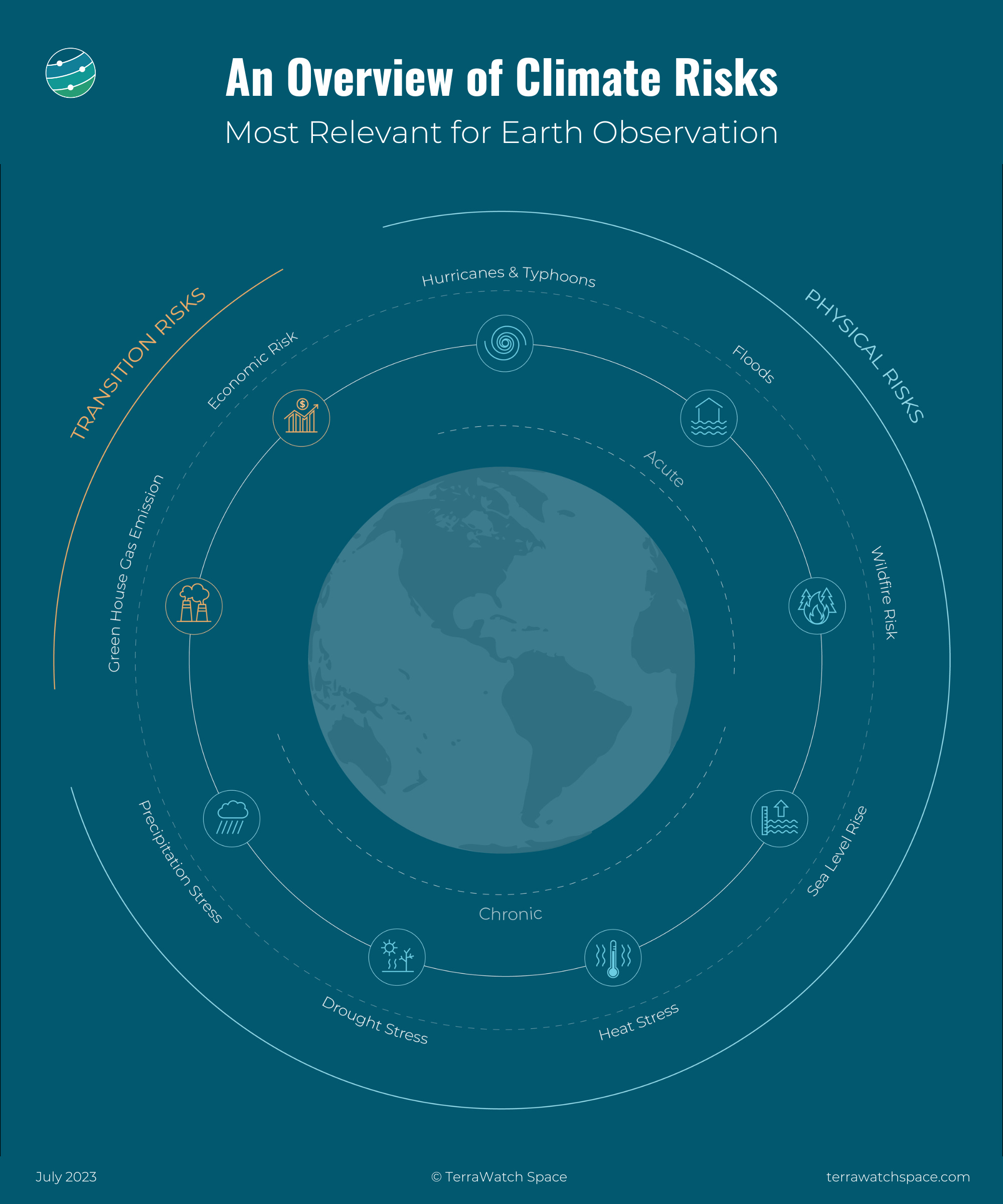
As some of you might know, public satellites have been collecting data for decades, and today’s climate risk models depend a lot on observations provided by those satellites. However, the commercial EO sector is growing, with at least 60 proposed satellite constellations, most of which have instruments that can support the estimation of climate risks in the future - at higher spatial, temporal and spectral resolutions. So, my question to you is this:
Scene from Space
One visual leveraging EO
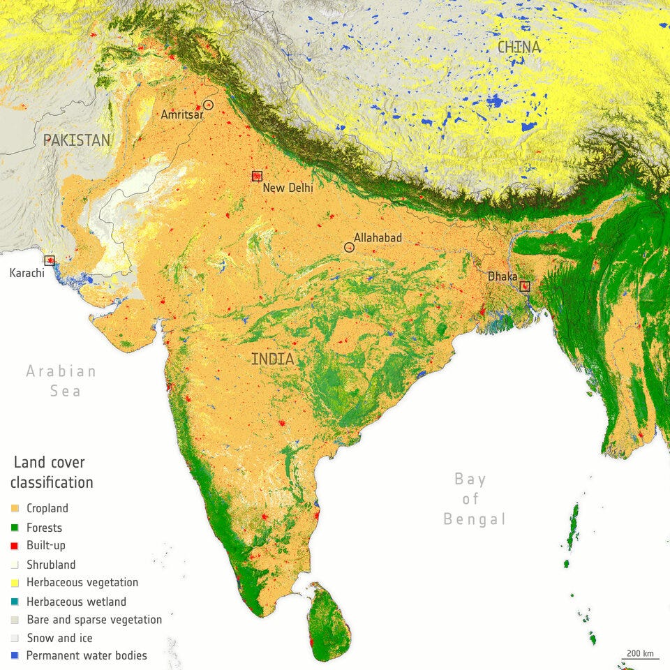
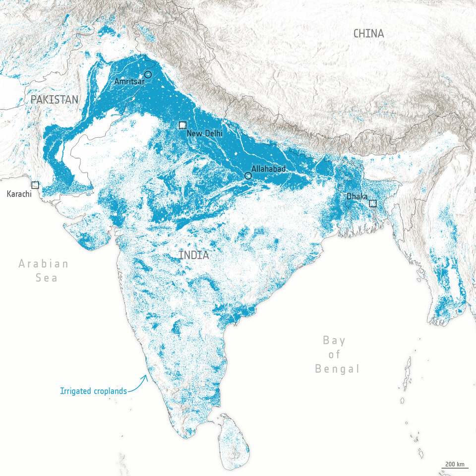
6. Monitoring Irrigation with Satellite Data
Globally, more than 70% of the freshwater withdrawn from the Earth’s surface or from underground is used to irrigate agricultural crops. It is estimated that worldwide around 2500 cubic kilometres of water is used for irrigation every year, which is more than is used for any other single purpose.
Data from satellites act as a global truth to not only identify trends in irrigation but also the effects of irrigation practices in and around croplands. Recent research supported by ESA looked at the links between irrigation and the global environment, specifically the feedback loops. Hopefully, such work could help avoid cases like this one, in which a drought-ridden state in the US did not know how much water a company was consuming.
The following figures from ESA, show the land cover classification map of India as well as the extent of irrigation.
Until next time,
Aravind.


