

Welcome to a new (belated) edition of ‘Last Week in Earth Observation’, containing a summary of major developments in EO from last week and some thoughts on the sector that I have come to love.
In this edition: mapping the global oceans, greenhouse gas emissions, climate anomalies, vertical integration, verticalisation and other strategic dilemmas in EO for data providers, downstream companies and end-users.
Four Curated Things
Major developments in EO from the past week
1. Contractual Stuff: Funding, Contracts and Deals 💰
- Thermal infrared EO company Hydrosat is acquiring IrriWatch, a Dutch early-stage agriculture analytics startup (my thoughts on this);
- BlackSky was awarded a two-year multimillion-dollar ground station infrastructure augmentation contract by a Ministry of Defense customer;
- Nuview, which aims to launch a constellation of lidar-equipped satellites has raised $15 million including from Leonardo DiCaprio;
- SAR data company Capella Space was awarded a multi-year agreement by NASA, with contracts that could be valued at $7M per call;
- Global Fishing Watch, a non-profit focused on monitoring global fishing was awarded a $60M contract by the Audacious Project for openly mapping and publishing human activity on the oceans;
- The stocks of Planet dropped by at least 25% after the company lowered annual revenue guidance from $248 million and $268 million to $225 million to $235 million for fiscal year 2024;
- Earth observation services firm Serco was awarded a contract by ESA for the implementation of Europe’s Destination Earth platform, an initiative to create the digital twin of the planet.
2. Strategic Stuff: Partnerships and Announcements 📈
- Greenhouse gases monitoring data provider GHGSat is partnering with UK’s Satellite Applications Catapult to provide UK organisations with access to high-resolution methane emissions satellite data;
- EO marketplace SkyFi is joining hands with very high-resolution, stratospheric imagery provider Near Space Labs;
- Sidus Space, which offers space-as-a-service for EO announced that its satellite equipped with multispectral, hyperspectral and edge compute capabilities in 2024;
- Climate risk analytics provider Jupiter Intelligence announced that Fannie Mae, a mortgage-backed securities firm will be integrating Jupiter’s products for climate risk assessment (more context on this here);
3. Interesting Stuff: More News 🗞️
- A new ESA project will demonstrate how artificial intelligence could use satellite data to help certify organic cotton farms in India to prevent fraud;
- France’s mapping agency IGN launched a new public-private partnership initiative to integrate solutions from EO startups into ecological mapping projects (in French);
- As greenhouse gas emissions reached an all-time high, a new study provides an update on the indicators of the state of the climate system and human influence, some of which uses EO data to compare the state of indicators used in IPCC’s Sixth Assessment Report (AR6), published in 2021.
4. Click-Worthy Stuff: Check These Out 🔗
- This webinar from Spire on why businesses should care about space, in which I will be talking about how EO can provide competitive advantages for businesses;
- This report from UNOOSA on the role of space technologies in the world, which recently exceeded a population of 8 billion;
- This piece that looks into how Google Earth Engine became a key tool for monitoring deforestation around the world;
- This article that tells you everything that you need to know about understanding wildfires;
- This deep-dive that provides an excellent report on the state of forest monitoring and how advancements in EO will help improve it further;
Subscribe for more Earth observation insights!
One Discussion Point
Analysis, thoughts, and insights on developments in EO
5. Strategic Dilemmas in Earth Observation
I took some time to put together some thoughts on the big strategic dilemmas in Earth observation for data providers, downstream companies and end-users.
- EO data providers: To vertically integrate or not? To verticalize or not?
- EO downstream companies: To productize the project or projectize the product?
- End-users of EO: In-house EO vs outsourced EO vs off-the-shelf EO product?
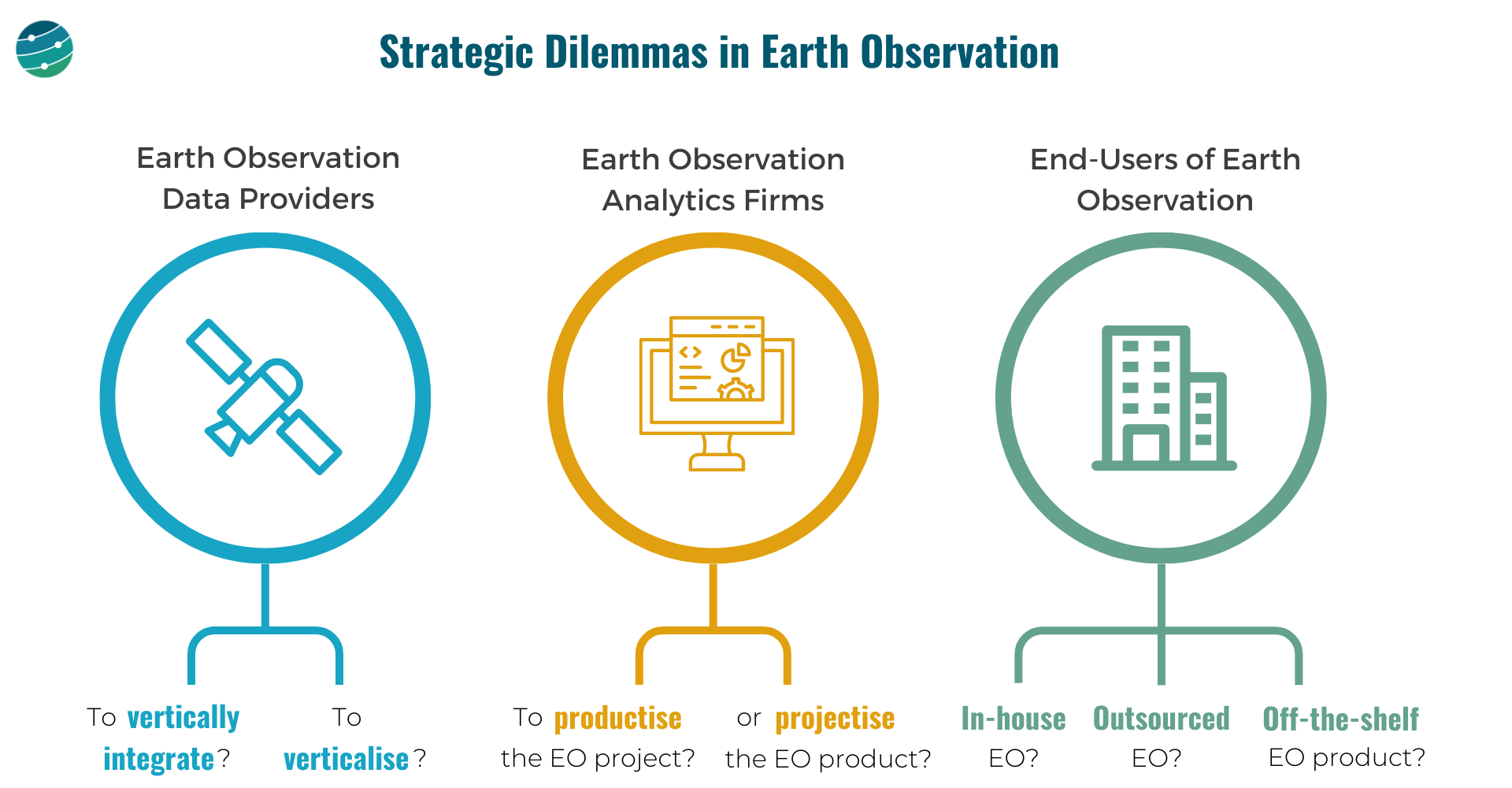
EO data providers
These are companies that are in the "Data" layer of the EO value chain. And they, have 2 important choices to make:
- Whether to own as much as possible of the EO value chain or outsource most of the build, launch & ops of the satellites and just receive the data. And how far down the value chain should they go, just provide data? Or, go one more step further and offer analytics? Where to draw the line?
- Whether to focus the go-to-market efforts on a specific vertical (insurance, ag, infrastructure etc.) or to remain horizontal and serve as many markets as possible? Companies that verticalize could have an easier route to achieving product-market fit and scalability.
EO downstream companies
These are companies that operate in the "Insights" and "Application" layers of the EO value chain. They need to decide:
- How to convert the customised EO projects (solve a problem for each customer) into an EO product (that solves that problem scalably for many)? When do you say no to more projects and decide to work on a scalable product?
- Can you still pick projects selectively? Assume the current version of your EO product fits only 60% of a large client's requirements, while the other 40% does not fit into your product vision. Do you forego the big client for the product or can you afford to efficiently 'projectize the product'?
End-users of Earth Observation
The end-users of EO, who come from several sectors such as agriculture, insurance, finance, infrastructure, mining etc. have some tough choices to make:
- Do they go with an in-house EO strategy i.e. build or expand the internal geospatial teams, design their own EO strategy, acquire data from several EO data providers and develop internal solutions with the data?
- Or, do they go with an outsourced EO strategy i.e. pick a geospatial consultancy to build custom products as per requirements and abstract themselves from most of the EO choices and challenges, leaving it in the hands of a custom EO solution provider?
- Or, can they find off-the-shelf EO-based products for their use case available in the market that fit their needs? A caveat is although some of these products offer ready-to-integrate analytics, the methodologies used for the work may not be transparent (aka ‘black boxes’).
— — —
These are some of the learnings gathered through the past year of work via TerraWatch Space with EO data providers, EO analytics firms and end-users of EO, from around the world. If you are thinking through these strategic questions in your organisations, I am happy to help!
Scene from Space
One visual leveraging EO
This is a new section where I want to link an image or a video based on EO that is interesting or cool or informative (or all of the above), that caught my attention.
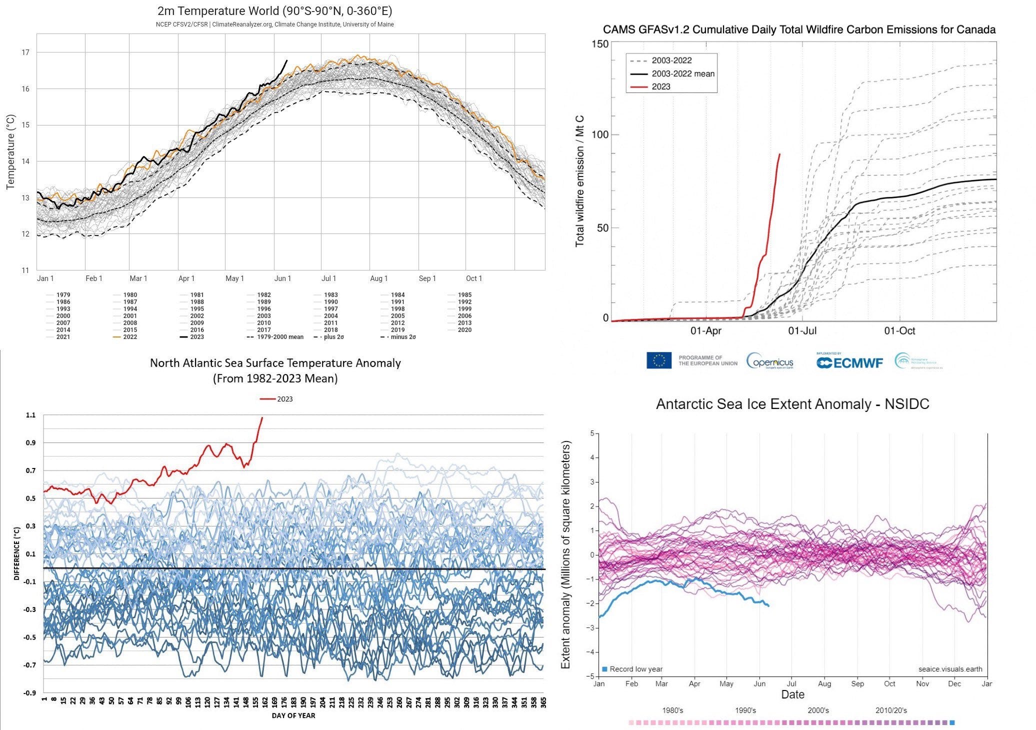
6. Entering a new era of climate records
I found this collection of graphs that show some climate records we have hit recently, containing measurements made from satellites and other sources. I took some time to independently verify them and the numbers don’t seem to lie. It does not look good, from a number of angles. But, we expected this.
Read clockwise: average air temperature at 2 meters above the surface, daily total wildfire carbon emission for Canada, North Atlantic sea surface temperature anomaly and Antarctic sea ice extent.
A quick update on the TerraWatch Space podcast
There will be only three more new episodes of the podcast. From July, I will be taking an indefinite break from podcasting. As much as I want to continue, I have decided to prioritise and double down my efforts on this newsletter and the blog - so expect more deep dives, some for all subscribers and some exclusively for premium subscribers. Thank you for the support!
Until next time,
Aravind.


