

Welcome to a new edition of ‘Last Week in Earth Observation’, containing a summary of major developments in EO from last week and some thoughts on the sector I have come to love.
In this edition: Europe’s big EO contracts and why they are a big deal, geospatial search engine, irrigation from space, floating villages and more.
Four Curated Things
Major developments in EO from the past week
1. Contractual Stuff: Funding, Contracts and Deals 💰
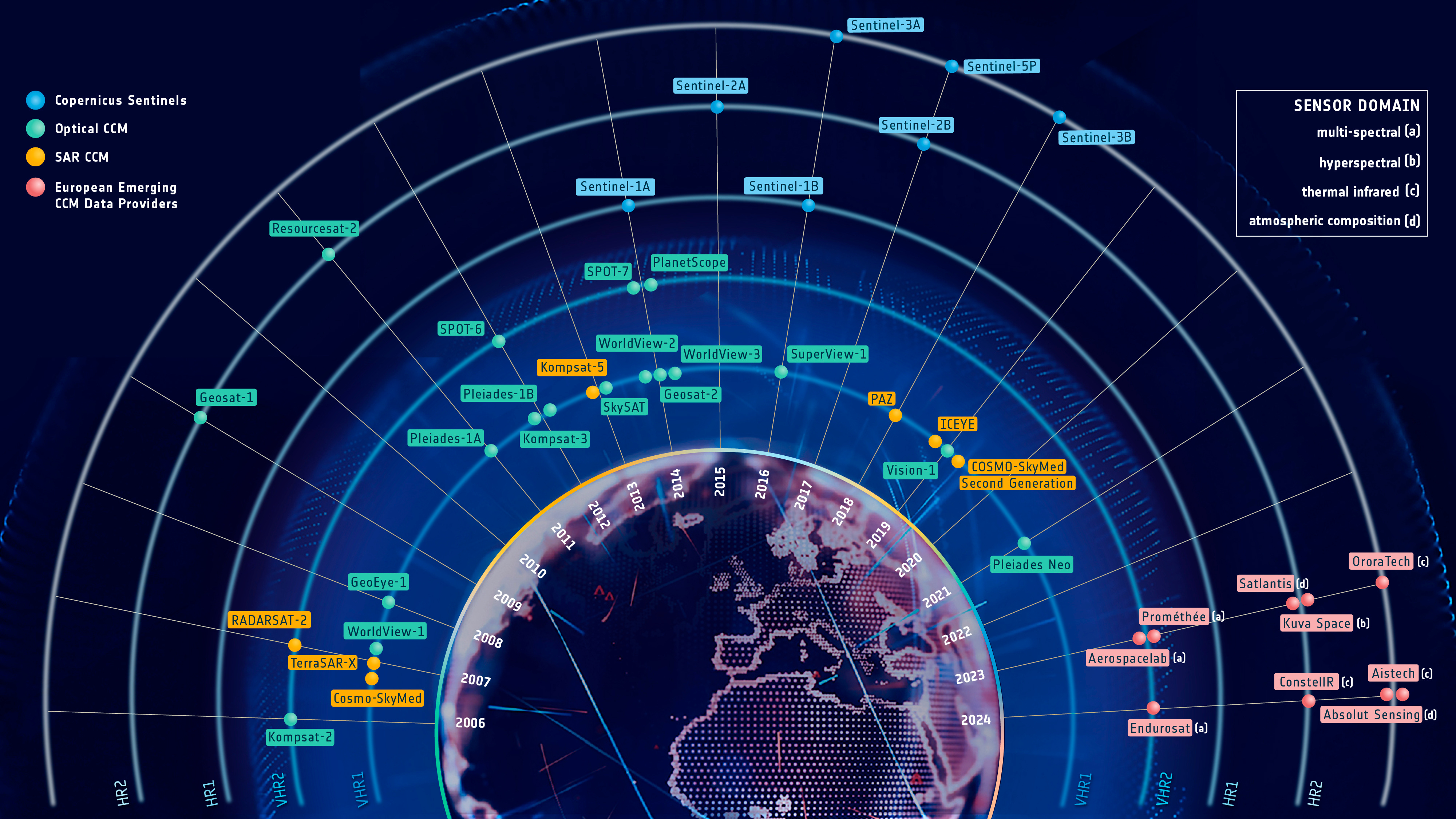
ESA and the European Commission awarded multi-million euro contracts to 9 European EO companies in order to integrate their data into the Copernicus Contributing Missions (more on this below). The awardees include:
Kuva Space from Finland providing hyperspectral imagery;
OroraTech and Constellr from Germany + Aistech from Spain providing thermal infrared data;
Aerospacelab from Belgium, Prométhée from France and EnduroSat from Bulgaria providing multispectral imagery;
Satlantis from Spain and Absolut Sensing from France providing data on atmospheric composition;
Danti, a startup building a search engine for geospatial data raised $2.75M in seed funding (read my 3-year old blog on A Google for Earth Observation);
NASA awarded greenhouse gas monitoring EO firm GHGSat, awarded a contract to provide the agency with methane emission data for evaluation;
Space infrastructure company D-Orbit won a contract from ESA and the Italian Space Agency to demonstrate optical inter-satellite links.
2. Strategic Stuff: Partnerships and Announcements 📈
- NASA announced the opening of the Earth Information Center to make EO data more accessible for use by governmental agencies and to communicate the value of EO to the general public;
- NanoAvionics will be building the first satellite of French EO startup Prométhée, aiming to launch a constellation of 20 satellites;
- Parametric insurance provider Skyline has partnered with Spire to provide data from its multi-sensor satellite constellation;
3. Interesting Stuff: More News 🗞️
- Qatar has launched an early warning system to monitor oil spills based on insights derived from satellite radar data;
- As the World Meteorological Organisation (WMO) continues to progress on its Early Warnings for All programme, Google provided some updates on how it aims to support this initiative;
- Scientists in Italy used data from ESA’s SMOS and NASA’s SMAP missions to map and measure the amount of water used in irrigation, which could subsequently lead to better water management.

4. Click-Worthy Stuff: Check These Out 🔗
- This piece that discusses why the warming oceans are confusing scientists;
- This webinar from Spire on why businesses should care about space, in which I will be talking about how EO can provide competitive advantages for businesses;
- This report on the 'State of the Climate in 2022 in Europe, from the WMO;
- The Energy Access Explorer tool, by the World Resources Institute, an open-source platform that uses satellite data along with other data sets to analyze energy demand and supply in unserved and underserved areas.
Subscribe for more Earth observation insights!
Two Discussion Points
Analysis, thoughts, and insights on developments in EO
5. Why the Contracts Awarded by ESA and the European Commission to EO Companies are a Big Deal
The concept of the Copernicus Contributing Missions (CCM) is not new, it has been going on for years. The primary users of the CCMs are the six Copernicus Services, as well as the EU Public Authorities (over 3000 registered users)1. Prominent EO companies including Maxar, Airbus, Planet, SI Imaging Services, Iceye etc. are all part of the CCMs.
Essentially, CCMs act as gap fillers filling the observational requirements and providing the much-needed data continuity for some of the end-users of the Copernicus programme. Some of these missions address gaps that the Sentinels are, for example, not able to provide (like very high-resolution imagery). And, as some of you might know, the Copernicus programme is evolving and commercial EO companies act as complementary datasets along with them.
In the US, apart from the DoD, satellite companies look to NASA and NOAA for not only the scientific validation of their datasets but also the commercial validation through data contracts. NASA’s Commercial Smallsat Data Acquisition (CSDA) aims to do exactly that, with contracts already in place for several companies including Planet, Maxar, Spire etc. In a way, the CCMs are the European equivalent of the CSDA, although they have programmatically different objectives. One of the biggest challenges for emerging EO data companies in Europe was the lack of institutional demand for EO.
I think the new CCMs contracts offer two things for the EO companies:
- A Validation of Demand: While the demand from the Copernicus programme does in no way represent the overall addressable market for the EO companies, it does give them a stream of continuous demand that they can fulfil with their initial missions. While this does create a virtuous cycle of dependency on institutional funding, this contract should provide a sense of cushion these companies badly need in order to focus on the commercial use cases. Some of these companies already have commercial revenues, so these contracts should really propel them forward.
- A Stamp of Credibility: While the contract ticks the commercial checkbox, the important one is credibility and technical validation. As EO companies look to scale up and raise more funds in a tough macroeconomic environment, this contract adds to their reputation, especially given that most of the companies have not launched a satellite or are in the early stages of demonstrating their technology in orbit. This is a step in the right direction and good news for EO in Europe.
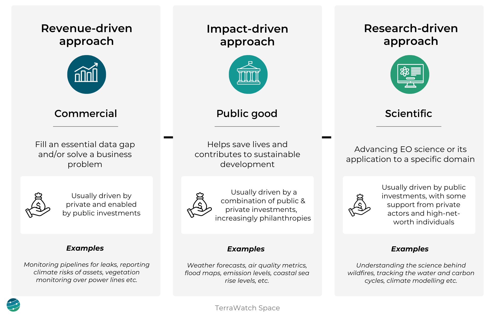
6. A Three-Pronged Approach to Earth Observation
Last week, I shared my thoughts on the types of EO products, especially what kind of Earth observation products we build, how they are adopted by users and most importantly, their financial sustainability. This week, I summarised my thinking with this infographic, with a blog post on this coming up shortly. Hopefully, that makes it easier to digest.
Scene from Space
One visual leveraging EO
7. Floating Villages of Tonlé Sap
This week, I wanted to share this timelapse of Tonlé Sap in Cambodia, the largest freshwater lake in Southeast Asia. I was lucky enough to visit this place a few years ago and experience life in the floating villages as well as the rich biodiversity of the ecosystem. The timelapse shows images from Planet between August to December 2022, showing how the lake floods as the Tonle Sap River flows in one direction and then empties out in December as the river flows in the other direction (yes, a bidirectional river!)2
However, due to increasing deforestation3 and climate change4, the timing and size of flooding have impacted the livelihoods of over a million people, who depend on Tonlé Sap for food and shelter.

One Podcast Episode
From the TerraWatch Space podcast
8. Earth Observation for Development: From Imagery to Impact
I am speaking with Rhiannan Price, Chief Strategy & Innovation Officer at DevGlobal, a consultancy that works in the development sector on impact projects with the world’s leading non-profits, companies, philanthropies, multilateral agencies, and government agencies.
Rhiannan has been working in Earth observation for a while, especially on the impact side of things. Prior to her role at DevGlobal, she led the Sustainable Development portfolio at Maxar, where she helped found their Open Data Program, among other initiatives.
In this conversation, Rhiannan and I talk about the use of Earth observation in the development sector, the journey of imagery from space to impact on the ground, the challenges of using Earth observation data, its potential in creating impact and more.
Until next time,
Aravind.
https://www.esa.int/Applications/Observing_the_Earth/Copernicus/Copernicus_Contributing_Missions ↩
https://www.cntraveler.com/stories/2015-02-02/maphead-ken-jennings-cambodia-tonle-sap-river ↩
Cambodia lost over a quarter of its total tree cover—more than 3 million acres of forest— between 2002 and 2021, according to Global Forest Watch. ↩
https://www.dw.com/en/cambodia-climate-change-mekong-dams-threaten-worlds-biggest-inland-fishery/a-59274218 ↩


