

Hey! Welcome to a new edition of ‘Last Week in Earth Observation’, in which I attempt to curate the major developments in EO from the week that just passed and provide some thoughts & analysis on some of them.
The last week was pretty eventful in the world of EO. But before we dive into the edition, quick housekeeping …
Offer Extension: Get 30% off if you choose to become a premium subscriber of TerraWatch Space by March 10 (learn more in last week’s post).
Four Curated Things
A summary of some of the major developments in EO
1. Financial Stuff: Funding, Contracts and More 💰
- Airbus Defence and Space won a contract from Angola for their first Earth observation satellite, continuing the trend of sovereign EO globally;
- Maxar was awarded a contract by the US Army worth ‘tens of millions of dollars’ to provide geospatial data to construct 3D virtual models of Earth;
- Chloris Geospatial, a startup using satellite data to measure forest carbon closed a seed extension round from investors including AXA Investment Managers among others;
- Topolytics, a UK-based that uses satellite imagery among other sources for its waste management platform raised €1.7M.
- The Canadian Space Agency awarded ten contracts worth $6.8M to five different companies in the country for EO-related R&D projects.
2. Strategic Stuff: Announcements and Partnerships 📈
- Capella Space signed a multi-launch deal with Rocket Lab to launch four of their ‘Arcadia’ SAR satellites (possibly to replace these five falling birds);
- Thermal infrared startup, ConstellR signed a multi-launch contract with launch service provider ExoLaunch for launch of their satellites in 2024;
- Space-as-a-service company, Sidus Space has partnered with edge computing startup Exo-Space to provide edge AI capabilities into its planned satellite constellation;
- EO company Ursa Space, which focuses on data fusion with SAR, has added space-based radio frequency data from Kleos Space to its platform;
- Orbital Insight, an EO platform company, has partnered with Carahsoft, IT solutions provider to provide geospatial data analytics to the public sector;
- Near Space Labs will provide imagery from their stratospheric balloons to property risk insurtech firm Tensorflight.
3. Some Interesting Reads From The News 🗞️
- Microsoft announces Azure Orbital Space Software Development Kit, software tools to make it easy for developers to create space applications in the cloud and deploy them on spacecraft operated by Azure Orbital partners - Ball Aerospace, Loft Orbital, Thales Alenia Space and Xplore;
- Satellite IoT company, Astrocast was selected by Swiss Polar Institute to provide connectivity for for remote snow, glacier, and permafrost monitoring stations in Central Asia;
- EO company BlackSky has discovered details about China’s secret naval base in Cambodia using data from their satellites;
- The World Meteorological Organization will be running an Uncrewed Aircraft Systems to evaluate the use of drones for filling in atmospheric gaps in weather forecasting and monitoring;
- The Surface Water and Ocean Topography (SWOT) mission from NASA, that was launched, last year to map Earth's surface water has suffered an instrument shutdown in orbit (hoping everything works out well soon!);
- The Egyptian Space Agency has an EO satellite to its fleet, Horus-1, built and launched under strategic cooperation between Egypt and China;
4. Some Interesting Things To Check Out 🔗
- Hyperspectral imagery (+ more) from the first satellites of Pixxel;
- This report from the First Street Foundation found millions of properties in the US that will be exposed to damaging winds due to climate change;
- This paper showing how climate risk is not included in housing prices and the consequences of that (hint: EO data is already playing / will play a role);
- This research showing how fast glaciers in Antarctica are draining their ice during summer, using Sentinel-1 imagery between 2014 and 2021;
- This course on the applications of SAR data, by a SAR expert;
- The US President’s Council of Advisors on Science and Technology submitted a report modernising wildfire monitoring in the country (which contains at least some relevance for the EO sector).
Two Discussion Points
Analysis, thoughts and insights on some developments in EO
EO Hype Cycle
A few years ago I published this blog exploring the question if we are close to reaching the ‘iPhone moment for Earth Observation.’ While whether we are closer today than we were back then would make for an interesting discussion, I wanted to look back at the ‘EO Hype Cycle’ that I had developed to include in the piece (inspired by the popular framework from Gartner).
For that, I took the findings from my experience in EO and mapped the technologies on the axes of Expectation vs Time, while also assigning a ‘predicted timeframe’ by which those technologies would have become mainstream.
For a refresher on the Gartner methodology and the definition of these terms, please check out my blog for a summary or the Gartner website, for more.
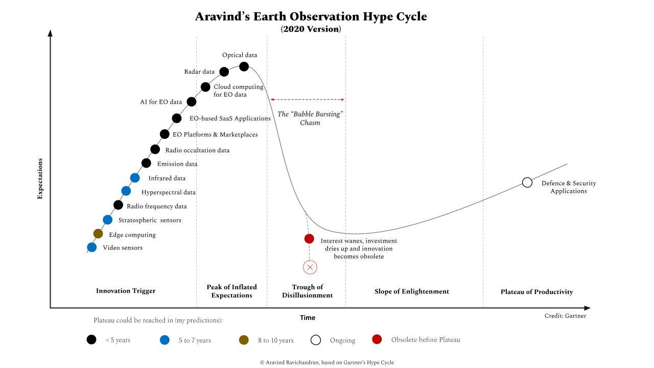
I will be publishing my 2023 version of the ‘EO Hype Cycle’ later this week. It will contain some analysis with the following two figures:
- EO Technology Hype Cycle: Where a specific EO technology is positioned on the hype cycle.
- EO Adoption Hype Cycle: Where the adoption of EO for a specific use case or within a specific industry is positioned on the hype cycle.
Watch out for that email in your inboxes!
In the meantime, I wanted to ask you, the EO enthusiasts, who are reading this, what you think is at the Peak of Inflated Expectations in EO today - separately, which EO technology and which use case within a sector for the adoption of EO.
Peak of Inflated Expectations is a phase when expectations reach maximum level and the innovation creates a lot of buzz, sometimes leading to a bubble.
I will include the results of these polls in my blog post to be published soon. Now, put your thinking caps on 🎩
5. EO Technology Hype Cycle: Peak of Inflated Expectations
6. EO Adoption Hype Cycle: Peak of Inflated Expectations
Two Podcast Episodes
From the TerraWatch Space podcast and elsewhere
7. Mapping Floods in Near-Real Time with Satellite Data for Parametric Insurance
Floodbase, which used to be called Cloud to Street, before their rebrand recently, is a climate-tech startup using satellite imagery to build flood data products for use by the insurance sector. I had two guests from the company on the podcast - Bessie Schwarz, co-founder & CEO and Subit Chakrabarti, VP of Technology.
In the episode, we discussed what they are up to at Floodbase, what parametric insurance means, their tech stack, how they are using satellite imagery to build real-time flood maps for the insurance sector, why they publish their scientific methodologies, the challenges of using Earth observation data and more.
8. Demystifying Some Earth Observation Jargons
I had the opportunity to be on the other side of the table, as a guest on the Constellations podcast, where I took a stab at demystifying some EO jargons listed below. Have a listen and let me know what you think!
Data-as-a-service, analytics-as-a-service, insights-as-a-service, space-as-a-service, satellite-as-a-service, data fusion, onboard computing, sovereign earth observation, EO space strategy, EO data strategy etc.

Subscribe for more Earth observation insights!
Until next week,
Aravind.


