

Hey! Welcome to a new edition of ‘Last Week in Earth Observation’, in which I attempt to curate the major developments in EO from the week that just passed and provide some thoughts & analysis on some of them. Lots to catch up on in the world of EO, so let’s get rolling!
PS. Very grateful to everyone who upgraded to become a premium subscriber of TerraWatch Space. Your monthly exclusive deep-dives will start next week!
Four Curated Things
A summary of some of the major developments in EO
1. Financial Stuff: Funding, Contracts and More 💰
- iQPS, a Japanese SAR startup raised JPY 1B, bringing its total to JPY 9.2B since it was founded in 2005;
- BlackSky reported Q4 earnings with over $65M in revenue for 2022, announced a $150M contract with an unnamed international ministry of defense customer and also raised $29.5M in private placement funding;
- Spire also reported Q4 earnings highlighting annual recurring revenues of nearly $100M and a strong growth outlook for 2023;
- GHGSAT, the emission data provider entered into a data licensing agreement with commodities information provider, S&P Global Commodity Insights;
- A consortium led by e-GEOS, an Italian EO joint venture between Telespazio and the Italian Space Agency, won a €36M contract for Copernicus Emergency Management Service from the European Commission;
- Floodbase and FloodMapp, two startups building near-real-time flood maps received contracts from the US Federal Emergency Management Agency;
- Axim Geospatial, recently acquired by NV5 Global, won a $9M contract for building geospatial intelligence solutions from the US DoD.
2. Strategic Stuff: Announcements and Partnerships 📈
- Iceye announced its partnerships with reinsurance leaders, Guy Carpenter and Swiss Re, for a parametric pilot program to protect low-income communities in New York City from flooding;
- Planet will be providing satellite data to French intelligence firm Preligens, which will use the data for building situational awareness solutions;
- EO platform, Sinergise and satellite imagery marketplace, Geocento are joining hands to facilitate easier access to satellite data;
- Sinergise expanded its partnership with Planet on agricultural solutions;
- French startup Agenium Space is partnering with Bulgarian satellite integrator, EnduroSat to explore the implementation on-board processing;
- NASA and the Italian space agency will work together on the Multi-Angle Imager for Aerosols mission aimed at investigating the health impacts of tiny airborne particles;
- Edge computing startup Ubotica announced the launch of CogniSAT-CRC solution that promises to deliver at least a six-fold increase in useful data capture per orbit through image compression and cloud removal techniques.
3. Some Interesting Reads From The News 🗞️
- China Aerospace Science and Industry Corp is planning to launch a low-altitude (150 to 300 kms) EO satellite constellation;
- The Executive Council of the WMO approves plans for Global Greenhouse Gas Monitoring Infrastructure and Early Warnings for All initiatives;
- Small satellite provider, AAC Clyde Space is continuing its transformation into a Space Data as a Service company with its contract with hyperspectral satellite startup, Wyvern;
- ECMWF announced that the demonstration products of the EU’s Destination Earth (DestinE) initiative will be ready by mid-2024;
- Aerospace firm Elecnor Deimos completed a study concept for an EO constellation based on on-board processing of optical and SAR satellite data;
- The International Space Station adjusted its orbit to avoid a close approach by an EO satellite from Satellogic, giving more evidence of orbital congestion.
4. Some Interesting Things To Check Out 🔗
- Over 1,000 super-emitting methane leaks detected through satellite data;
- Estimating forest loss by processing gigabytes of SAR data from Sentinel-1;
- Using satellite data to estimate net carbon emissions of over 100 countries, including 50 that have not reported emissions for at least the past 10 years;
- First-of-its-kind analysis of satellite observations of air quality shows very few parts of the planet are actually at safe levels;
- A “future flood map” of the UK simulating the impact of flooding showed which regions will be most impacted along with overall costs to economy;
- This course on “Introduction to Machine Learning for Earth Observation” from EUMETSAT;
- This piece on the recently launched NASA ACRES project aimed at engaging with farmers and understanding impact of satellite data;
Subscribe for more Earth observation insights!
Three Discussion Points
Analysis, thoughts and insights on some developments in EO
5. Why is Earth Observation Media Coverage So Bad?
Last week, Japan’s H3 rocket failed in its inaugural launch attempt and with that, destroyed the primary payload, the Advanced Land Observing Satellite-3 (ALOS-3), an important EO mission that cost $280M. Considered to be an advancement mission over the first ALOS satellite, that launched in 2006, ALOS-3 had the following capabilities:
Optical imagery at a spatial resolution of 80 cm, with a wide swath width (which is the size of each strip acquired by the satellite) of 70 km.
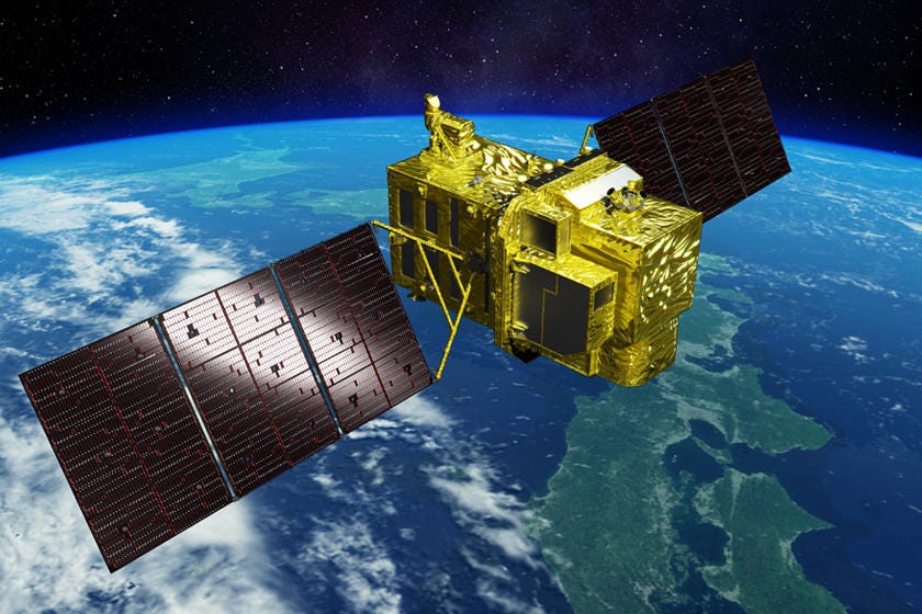
The launch failure of H3 vehicle has major consequences on Japanese independent access to space, but more importantly, the failure of ALOS-3 missions is a major loss for the EO community, not just because of the data that ALOS-3 would have been able to capture at high resolution (80 cm), but also that coupled with the wide swath width (70 km). I am not aware of any other satellite today, other than the Chinese Jilin-1, that captures imagery at this swath, at this resolution, and there is none planned, other than from Indian EO startup, SatSure.
Imagery from ALOS-3 would have been a boon for some commercial use cases requiring continuous wide area monitoring - transmission lines, pipelines, utilities and other infrastructure. Alas, we now have to make do with mosaics of the narrower strips, captured by other EO satellites. Which brings me to my point:
Why is Earth Observation Media Coverage So Bad?
The failure of the H3 rocket was covered by several media outlets (even the New York Times). While some made limited reference to ALOS-3 within their coverage with no mention of its significance, others made no reference to ALOS-3 at all, choosing to instead focus on the specifics of why the launch failed. The coverage was so deficient that even the most prolific launch reporter of our times didn’t notice at first that there was an important EO mission as the payload.
But guess what? I’m disappointed but not really surprised to see most of the coverage ignoring the loss of the EO satellite and its importance. As much as every article gets into the specifics of why the launch failed, I’d have liked more attention to the fact that data continuity will be disrupted from yet another important EO satellite. Given this state of media coverage for EO, is the lack of awareness of EO a surprise?
PS. I never intended for TerraWatch to become a full-on media company doing EO reporting - I just wanted to focus on analysis of the developments in EO, by providing insights and occasional deep-dives of the market. But, it looks like there is a certain gap in media coverage of EO. Do you agree? Let me know!
6. NASA Budget Proposal for 2024: Did EO Warrant an Increased Budget?
NASA proposed a budget $27.2B for NASA in 2024, with approximately $2.5B (9%) earmarked for Earth science. While the final budget allocation might look different as this is only the US administration’s proposal, it is worth pondering whether EO deserved as much as it got, and the future of EO under NASA. I have classified my thoughts into three categories:
a) The Future of EO Science
The budget comes at a time when important EO science missions of NASA are suffering budget crunches, meaning some of them might end up getting decommissioned despite their high performance and the high significance of the data they are collecting. The impact might also be on future EO missions, including the major line of missions, called Earth System Observatory, that NASA is currently planning (NISAR, launching in 2024, is the first of those).
I have already ranted about the lack of attention on the future of EO under NASA, especially the lack of discussions on pathways to implement future EO missions, choosing among NASA-led (NASA leads design and outsources development to private sector), private-led (industry leads design and development with NASA acting as an anchor customer) and a to-be-defined hybrid working relationship model.
b) Transitioning Scientific EO into Operational EO
We also need more conversations on an important point that was raised on Twitter (by researcher Jack Reid): Which EO satellites should become operational missions, out of the ones launched by space agencies?
While several EO satellites launched by space agencies are scientific missions with science and research as their primary goal (and they have certainly been successful at that) many of them have actually become fundamental to operational use cases, whether it is for governmental use, like policy monitoring for tracking climate goals or commercial use, in industries like agriculture, utilities and insurance sectors - take, for instance, the uptake of data from SMAP, ALOS-2 or Sentinel-1/2 by companies.
How do we make sure that we continue to advance Earth science while making sure that users who have (somewhat serendipitously) become dependent on data from some EO science satellites continue to operate without risk of data discontinuity?
c) Building Operational EO Tools & Dashboards
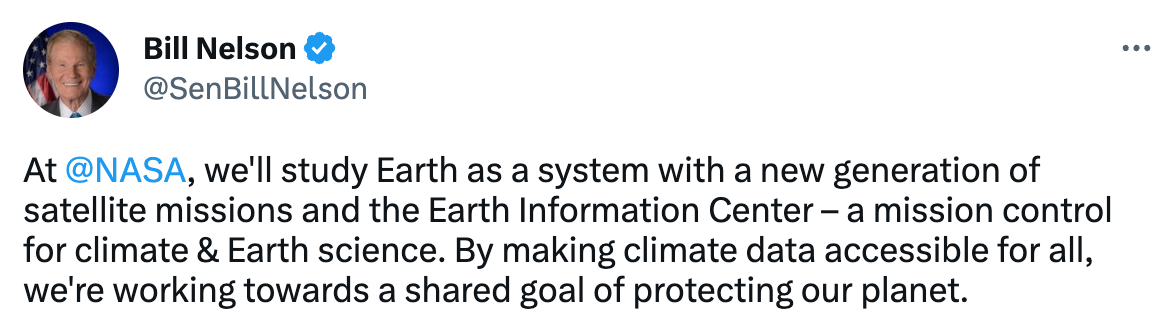
NASA Administrator Bill Nelson tweeted that the agency will be building a new Earth Information Center - a sort of mission control unit for climate and Earth science with an aim to provide easy-to-use information derived from satellites to support decision-making - from temperatures to sea-level rise, emissions to agriculture among many others. This sounds ambitious and if you know much about the lack of useful, usable data products in EO, so certainly substantial.
But, the big question is does NASA really have the EO budget to implement this and make it operational? I will put on my pessimistic optimist hat for this one!
7. More EO Science, But Does That Mean More Impact?
There is so much good research being published using EO data these days across multidisciplinary domains, from climate change to economic development, from urban planning to agriculture and more. Some of this research pushes science forward while some papers actually have the potential to be included in product roadmaps, given how groundbreaking some of them are.
I think, read and write about EO for a living - and even for me, I find it very hard to keep track of all the amazing science we are doing with satellite data. I try and include every interesting publication I find in point #4 (Some Interesting Things To Check Out) every week. And, to be honest, we are actually just starting out - expect more science based on satellite data to come in the next few years!
As much as that fills me with positivity and hope, I ask myself: How much of that science actually leads to action and translates into real impact?
What should we be doing as a community to make sure that happens? Maybe, first, we might need to remind ourselves that success is not about identifying a new EO methodology, developing a new algorithm to process EO data or publishing a scientific paper with interesting findings; success is probably only achieved when some of that research is translated into verifiable impact within the respected domains (whether it is agriculture or emissions).
Perhaps, as the first step towards that, we may need to break outside the EO bubble so that those sitting within the specific domains understand the significance/insignificance of the findings. We can only break the EO visibility threshold by communicating more about EO in a way that not only demystifies EO for everyone, but also helps them understand the ‘so what.’ This is one of the reasons TerraWatch exists and that is my North Star.
One Podcast Episode
From the TerraWatch Space podcast
8. State of Ground Segment for Earth Observation and Ground Software As a Service
The ground segment is so under appreciated in the space industry. I wanted to know why and understand how the process works in Earth observation. So, I had Brad Bode from ATLAS Space Operations, Inc. on the TerraWatch Space podcast to discuss these topics.
In this episode, Brad and I talk about what Atlas Space Operations does, why ground segment is so under appreciated, how EO companies work with ground segment, the difference between ground station as a service and ground software as a service, the entry of Microsoft and AWS into this space and what it means and more.
Until next week,
Aravind.


