Happy Monday, everyone!
Welcome to a new edition of ‘Last Week in Earth Observation’, containing a summary of major developments in EO from last week and some high-level thoughts on the sector that I have come to love.
In this edition: Commercial space-based lidars, biodiversity data from EO, analysing Russia’s industrial decline from satellite data, state of EO for climate and more.
Four Curated Things
Major developments in EO from the past week
1. Contractual Stuff: Funding, Deals and More 💰
- Nuview, a US-based startup that aims to launch LiDAR-equipped satellites came out of stealth mode, while also announcing that it closed its first round of funding last year and that it has also won a government contract;
- EO platform startup SkyWatch won a $1.1M contract from the Canadian Space Agency to advance the application of AI for EO mission planning and data management and distribution.
2. Strategic Stuff: Announcements and Partnerships 📈
Investment firm Seraphim Space selected nine startups to be part of its accelerator program, including two EO firms:
An Indian startup, GalaxEye Space, which aims to launch a constellation of multi-sensor (multispectral + SAR) satellites;
EarthEye, a startup from Singapore, which is building an EO platform for ordering and processing satellite imagery;
SAR satellite company, Synspective, is partnering with Thailand’s satellite operator Thaicom to provide real-time data for disaster management efforts;
Accenture is collaborating with climate intelligence provider Cervest (recently featured on the TerraWatch podcast) to provide climate risk information to its clients spanning across industries;
Spire launched a weather insights platform specifically aimed at the maritime industry, powered by data from radio occultation satellites;
Microsoft’s Planetary Computer integrated a new dataset on biodiversity called Biodiversity Intactness, derived by EO analytics firms Impact Observatory and Vizzuality (sample below, explore more on the link)

3. Interesting Stuff: More News 🗞️
Rocket Lab launched the first two of four satellites of NASA’s TROPICS mission, which aim to provide hourly data on storms forming in the tropics;
The UK will launch a new SAR satellite called CarbSAR which will demonstrate Oxford Space Systems’ deployable antenna;
China has operationalised a satellite data-derived platform to monitor ecological zones, which include over 30 percent of the country’s land area;
As more EO satellites launch, we will probably start seeing more requests like what we saw from BlackSky seeking permission to operate satellites in lower altitudes as they are running out of fuel;
Eumetsat and ESA released the first images from the Meteosat Third Generation Imager 1 (or Meteosat-12) which should improve short-term weather forecasting thanks to its improved resolution and new sensors.
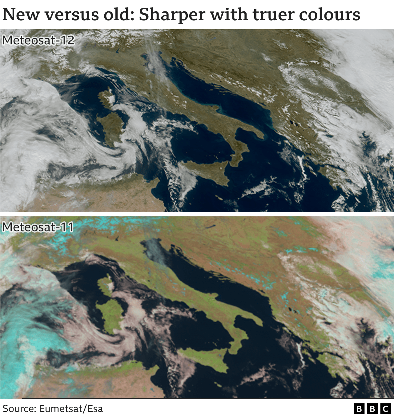
Credit: BBC
4. Click-Worthy Stuff: Check These Out 🔗
- This paper that explains the methodology behind the first map of all trees in Africa created using data from Planet’s EO satellites;
- This blog from Jed Sundwall (who has been on the TerraWatch podcast) that provides a new perspective on “open data”;
- This piece that looks at pollution data (from Sentinel-5P) to analyse the industrial decline in Russia (by French startup QuantCube);

Subscribe for more Earth observation insights!
5. Earth Observation for Climate: 2023 Edition (Coming Soon)
Around the same time last year, I published this deep-dive on the state of EO for climate in an attempt to demystify the developments in the private EO sector and its applications for everyone outside the sector. I continue to receive a surprising amount of traction and feedback on this piece, despite the fact that a year later, so much has changed in the climate space. So, thank you!

— — —
I have started to work on the 2023 edition, expected to be published in a few weeks. I try my best to track the climate tech sector and the use of EO within the space (shout out to resources like CTVC) - so the aim of the piece is to summarise the relevance of EO for climate application, discuss the emerging EO technologies and the commercial EO landscape and provide an outlook for the level of adoption of EO by organisations operating in the realm of climate tech.
As I am in the process of putting together this piece, I thought it might be a good idea to ask you, my readers, where you see the most important contribution of EO will be in the commercial climate-tech sector. Obviously, the importance of EO for climate, from a scientific perspective, is well documented and available for you to read through several sources. However, what I would like to do is to describe the state of EO for climate from a commercial perspective.
I will feature the results of this survey in the piece, which should provide a good reality check for the burgeoning EO sector. This brings me to…
One Podcast Episode
From the TerraWatch Space podcast
6. The Importance of Open Source, EO Projects vs EO Products, Boring Problems and More
If you have listened to this podcast before or read my blogs, you know what I mean by boring problems - those that are underrated and underappreciated, but unless we find a way to solve them, there is very less likelihood for Earth observation to go mainstream. Think about creating a standard approach to ingest, process and search for geospatial data or a standard format for placing satellite imagery orders from different providers.
I spoke to Dan Pilone, co-founder of Element84 and Robert Cheetham, founder of Azavea, which Element84 recently acquired. Both Element84 and Azavea are essentially service companies that focus on building solutions to solve important problems in the realm of processing, visualization, and analysis of geospatial data, with open-source software at their core.
In this episode, we talk about the two companies and how they came to be, the difference between a project and when it turns into a product, the importance of open source and its financial sustainability and more.
Until next time,
Aravind
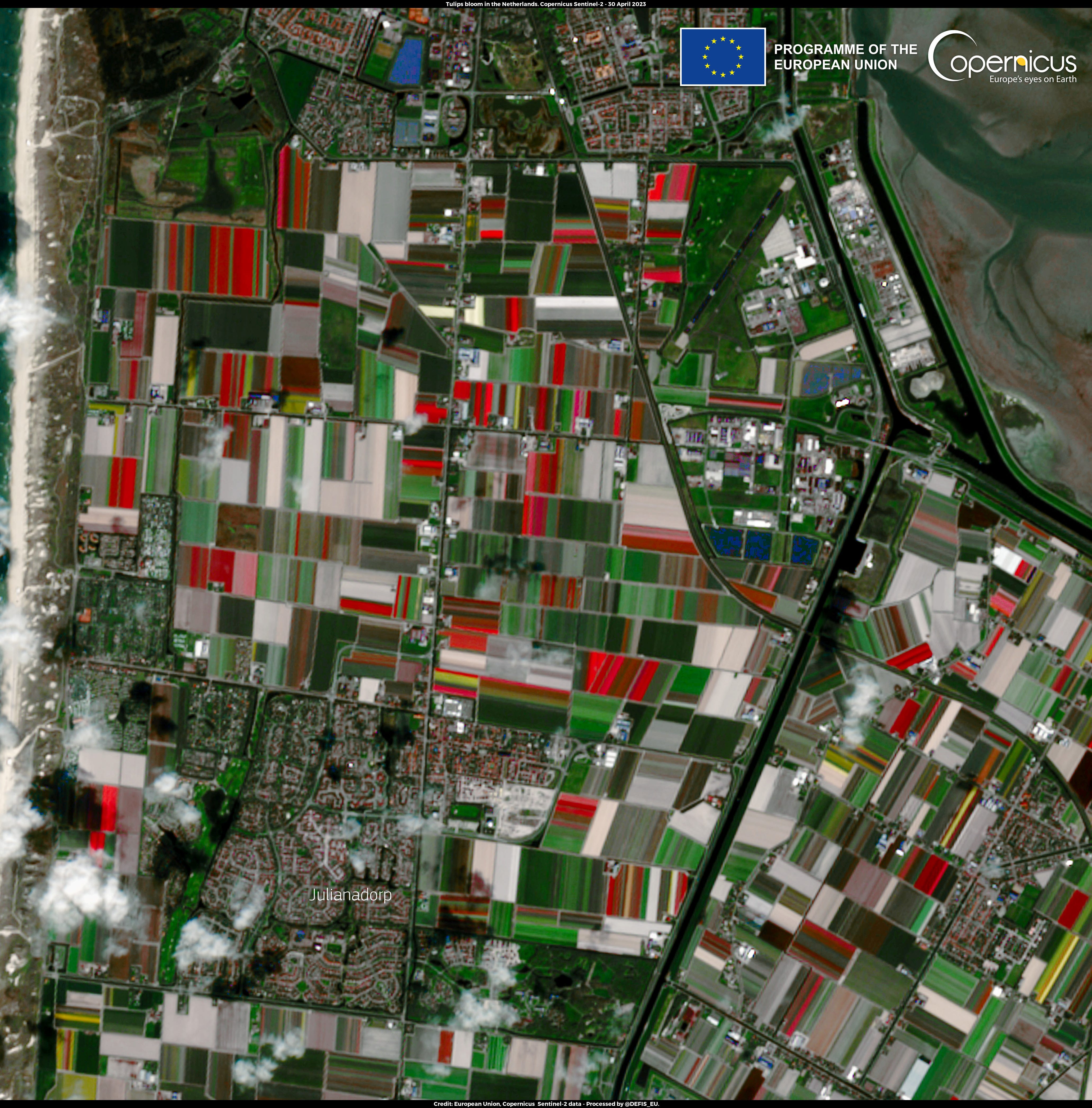
PS. I was in the Netherlands last week attending and speaking at the Geospatial World Forum. I saw some tulips from my plane, but this image does a better job!