

Welcome to a new edition of ‘Last Week in Earth Observation’, containing a summary of major developments in EO from last week and some exclusive analysis and insights from TerraWatch.
In this edition: State of SPACs, the impact of edge computing on the Earth observation value chain, monitoring crop nutrients with satellite data and more.
Four Curated Things
Major developments in EO from the past week
1. Contractual Stuff: Funding, Contracts and Deals 💰
Funding
- Vibrant Planet, a US-based startup building a wildfire risk management platform using EO data closed a $15M funding round;
- Treetoscope, an Israeli precision irrigation management startup based on in-situ, EO and weather data raised $7M in seed funding;
- Previsico, a UK-based provider of a platform predicting flood risk and flood impacts, using weather data, closed £1.75M;
Financials
CNBC published a summary of the state of space companies that went public through SPAC, along with a comparison of their market valuations and revenue projections (see below).
Of the EO companies in the list - Spire, Satellogic, BlackSky and Planet - only Planet seems to be ‘close’ to the forecast provided at the time.

2. Strategic Stuff: Partnerships and Announcements 📈
Partnerships
- ESA is partnering with European SAR data and solution provider Iceye to participate in the Civil Security from Space Programme aimed at improving disaster and crisis management using space technologies;
- Near Space Labs has signed a strategic partnership with property insurance provider Betterview for very high-resolution imagery from its proprietary stratospheric balloons;
- First Street Foundation, a non-profit focused on climate risk has partnered with American Family Insurance, an insurance company to provide customers and prospects with their property’s climate risk exposure;
Announcements
- Planet announced that a demonstration version of its next-generation, very high-resolution (30 cm) Pelican satellite will be launching next month;
- Services firm DevGlobal, in partnership with NASA, announced the launch of NASA Lifelines, a $6M, six-year initiative to bring humanitarians and scientists together to accelerate humanitarian decision-making using EO;
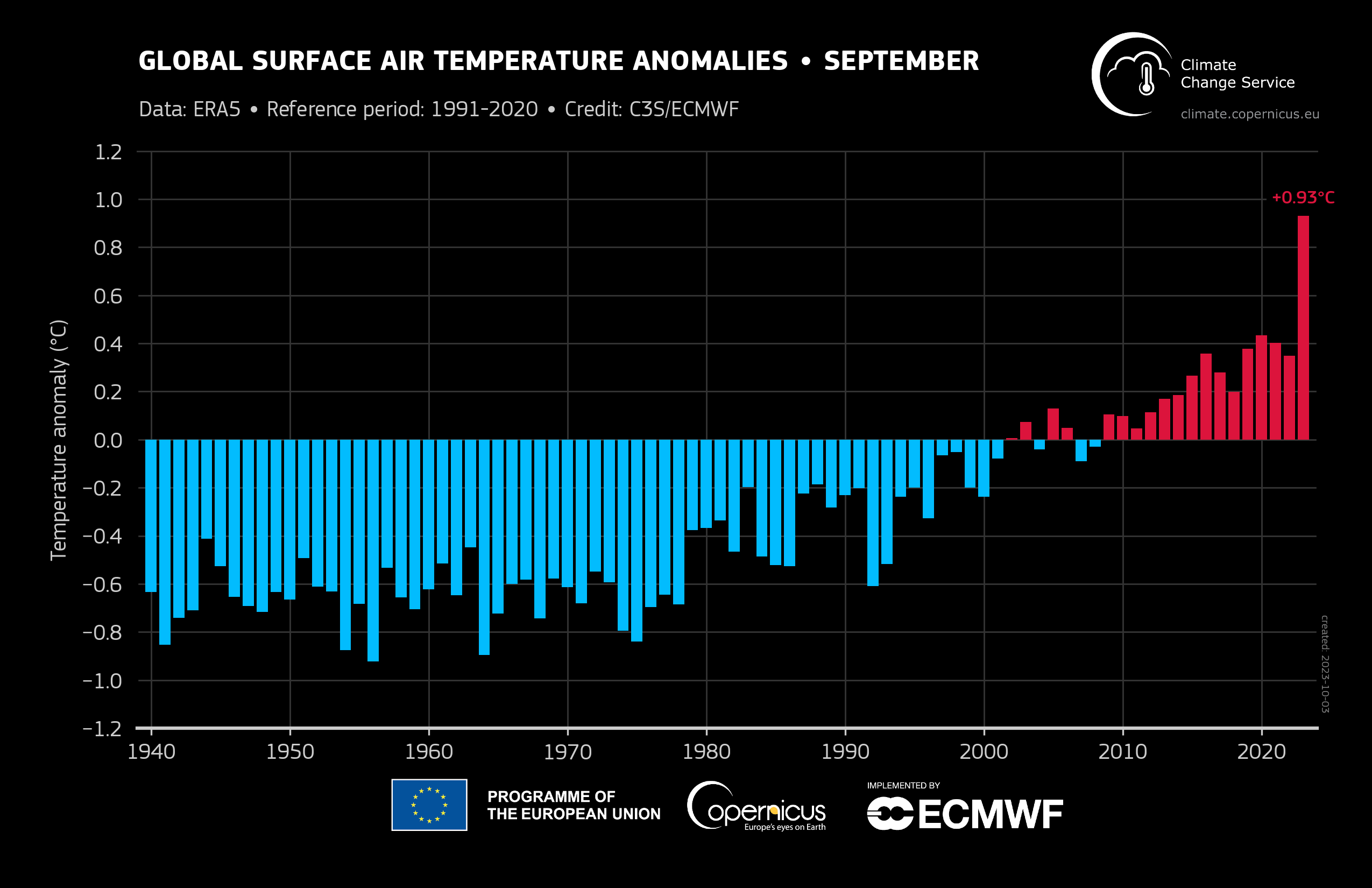
- Europe’s Copernicus Climate Change service reported that September 2023 was the warmest September globally in the data record going back to 1940, as this year shapes up to be the warmest on NOAA’s global climate record.
3. Interesting Stuff: More News 🗞️
- As the conflict unfolds between Israel and Hamas, the limits to collecting high-resolution satellite Imagery over Israel continue under the Kyl-Bingaman Amendment;
- European weather agency ECMWF has unveiled an alpha version of a new AI-integrated weather forecasting model;
- The US National Reconnaissance Office, which has started to rely on commercial EO companies for imagery, is also building new satellites to deliver ‘10 times more signals and images’;
- European launcher Vega deployed a high-resolution imaging satellite for Thailand and a weather satellite collecting radio occultation data for Taiwan, along with other technology demonstration cubesats;
- Chinese firm Changguang Satellite Technology has completed a high-speed laser image transmission test, improving its ability to downlink EO data.
4. Click-Worthy Stuff: Check These Out 🔗
- This piece that shows how NASA’s Harvest program used satellite imagery to identify estimates of abandoned croplands in Ukraine;
- This article that dives into how we are using satellites (like NASA’s SWOT mission) to understand disruptions to ocean currents due to climate change;
- This paper that discusses how data from satellites (like Sentinel-5P) can be used to monitor impact on air quality as a result of increased mining in Africa’s Copperbelt region.
If this was forwarded to you, please subscribe to receive Earth observation insights!
One Discussion Point
Analysis, thoughts, and insights on developments in EO
5. Impact of Edge Computing on the EO Value Chain
What impact can edge computing (or on-board processing) have on the EO industry, and more specifically, how does it affect the EO value chain?
If you have read anything from TerraWatch before, you know that I segment the EO Operating Stack into 5 segments: Data, Platform, Analytics, Insights and Applications. Edge computing might have some interesting dynamics on the Platform layer, but its impact on the Analytics layer is perhaps more fascinating.
As a reminder, the Analytics layer is the part of the EO value chain, where data is converted into useful information, sometimes by integrating other sources of data. However, note that the Analytics layer does not inform, it only translates. You might not be able to make direct decisions with Analytics, as you might need to contextualise the information. Some examples of Analytics are cloud detection, vessel identification, building detection, crop classification etc. As you see, Analytics is all about converting imagery on pixels into some information, but it is not an actionable insight.
And that is what edge computing brings to the table - the ability to process data onboard the satellite, as it is being taken, in order to convert this data into some form of useful information. Note that edge computing might not necessarily provide actionable Insights, nor can it become a usable Application. My thesis is that edge computing helps move the Analytics layer closer to the orbit, but not completely away from the ground, as the figure represents below.

As an example, edge computing may enable the detection of clouds in orbit, but might not succeed in detecting all clouds in the image from the start. It may enable the detection of vessels in the sea, but may not provide a 100 per cent accuracy to begin with. And, the power of edge computing may not be enough to detect objects that are inherently harder to detect scalably (like the different types of trees), especially objects that require a lot of training data. The differences between traditional AI (on the ground) vs. edge AI (in orbit) might have limitations on how much information it can derive. At least as long as we successfully build data centers in space, where training data can be stored.
So, what edge computing really does to the EO Operating Stack is it literally shakes things up a bit - moving the Analytics layer closer to orbit. At least for starters, some simple forms of Analytics like cloud detection and vessel detection can be “outsourced” to be performed on-orbit, while the more complex forms of Analytics such as building detection and crop identification might be harder to execute with limited training data available onboard the satellite.
For more on edge computing, check out the exclusive deep dive on the topic, which is accessible to paid subscribers. Not a subscriber? You can do it now!
Scene from Space
One visual leveraging EO
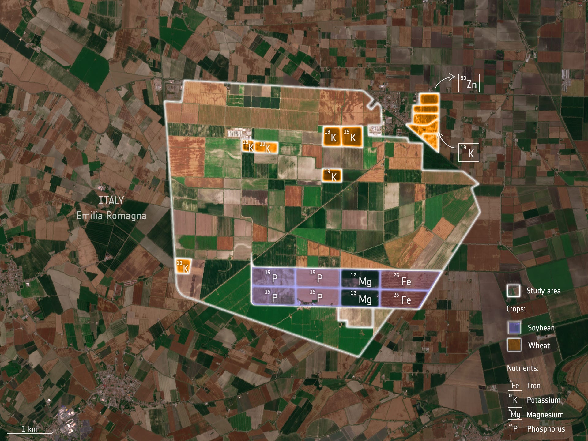
6. Monitoring Crop Nutrients with Satellite Data
The following image shows the results from research into the potential of using satellites to monitor crop nutrients over large areas. Data from the Sentinel-2 mission and the Italian Prisma mission were used to measure the nutritional content of staple crops, particularly potassium (K), phosphorous (P), magnesium (Mg) and iron (Fe), in soybean and wheat.
So what? Integrating insights from EO can enable farmers to intervene with fertilisers or other agricultural practices before they actually harvest.
PS. If you were not lucky enough to see the Solar eclipse or if you are not living in one of the places where it was visible (like me), then you might want to check out this cool animation, showing the sunrise, the eclipse shadow and the sunset - courtesy of NOAA’s GOES-East satellite.

Until next time,
Aravind.


