

Welcome to a new, belated edition of ‘Last Week in Earth Observation’, containing a summary of major developments in EO from last week and some exclusive analysis and insights from TerraWatch.
In this edition: Landslide risk forecasts, gaps in observing, forecasting and keeping track of weather and Canada's wildfire season.
Four Curated Things
Major developments in EO from the past week
1. Contractual Stuff: Funding, Contracts and Deals 💰
Funding
- CarbonFarm, a French startup, which offers an EO-based carbon measurement, reporting and verification platform for rice farming, raised a €2.5M seed round;
- Rhizome, a US-based startup, building a climate risk reporting platform for power grids, raised $2.5M;
- Environmental monitoring and water forecasting startup Upstream Tech received a strategic investment from Hull Street Energy, a private equity firm focused on the energy sector.
Contracts
- The Southwest Research Institute was awarded a $55M contract to supply the QuickSounder weather satellite, by NOAA, as part of the Near Earth Orbit Network programme;
- Japanese SAR company Synspective was selected by the country’s ministry for the Small Business Innovation Research system;
- Thales Alenia Space, with a consortium, won a contract from ESA to build a proof of concept of a flood prediction Digital Twin;
- Canadian space player MDA, which operates the Radarsat satellites for Canada, will be launching their next-generation, multi-sensor CHORUS constellation with SpaceX.
2. Strategic Stuff: Partnerships and Announcements 📈
Partnerships
- SAR firm Iceye is partnering with Indian geospatial company Suhora, who will get access to data from Iceye for building their EO solutions in Asia;
- Floodbase, an EO-based parametric insurance data provider is teaming up with African Risk Capacity Limited, an insurance company established by the African Union to build parametric flood insurance products for Africa;
- Bloomberg is partnering with climate risk startup Riskthinking.AI to have the latter’s physical climate risk indicators on the Bloomberg Terminal;
- Flood risk intelligence provider Fathom is collaborating with catastrophe risk management firm EigenRisk;
- The US Air Force Research Laboratory has announced research agreements with two Indian startups, with one focusing on EO sensor development.
Announcements
- The Open Geospatial Consortium (OGC) has announced that the Cloud-Optimized GeoTIFF format has been adopted as an official OGC standard, paving the way for its adoption as a preferred EO data cataloguing format;
- NASA’s EO-based landslide risk forecasting tool has been integrated into Pacific Disaster Center’s multi-hazard monitoring platform enabling predictions of rainfall-triggered landslides around the world.
3. Interesting Stuff: More News 🗞️
- China has launched a cluster of SAR satellites, named PIESAT-1, to acquire topographic data using interferometric SAR techniques;
- A new report from Brazil has mapped illegal mining activities in the Amazon, thanks to analysis of satellite imagery;
- Global Methane Hub, a non-profit that maps methane emissions at landfills around the world using data from EO, will be launched during COP28;
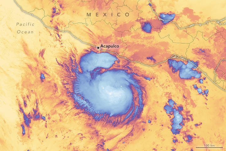
- Hurricane Otis, which has caused major damages in Acapulco on Mexico’s Pacific Coast, was missed by almost all weather models and has shocked weather forecasters - from a tropical storm early in the day to a Category 5 storm near midnight;
4. Click-Worthy Stuff: Check These Out 🔗
- This paper, which presents the results of using data from spy satellites from the 1960s to investigate Rome’s fortifications, with historical implications;
- This report from the UN’s Food and Agriculture Organization on using satellite data for monitoring evapotranspiration (i.e. the combined processes which move water from the Earth's surface into the atmosphere);
- This paper, showing the impact of rubber on global deforestation, using insights derived from satellite imagery.
If this was forwarded to you, please subscribe to receive Earth observation insights!
One EO Discussion Point
Exclusive analysis and insights from TerraWatch
5. Fixing Gaps in Observing, Forecasting and Keeping Track of Weather
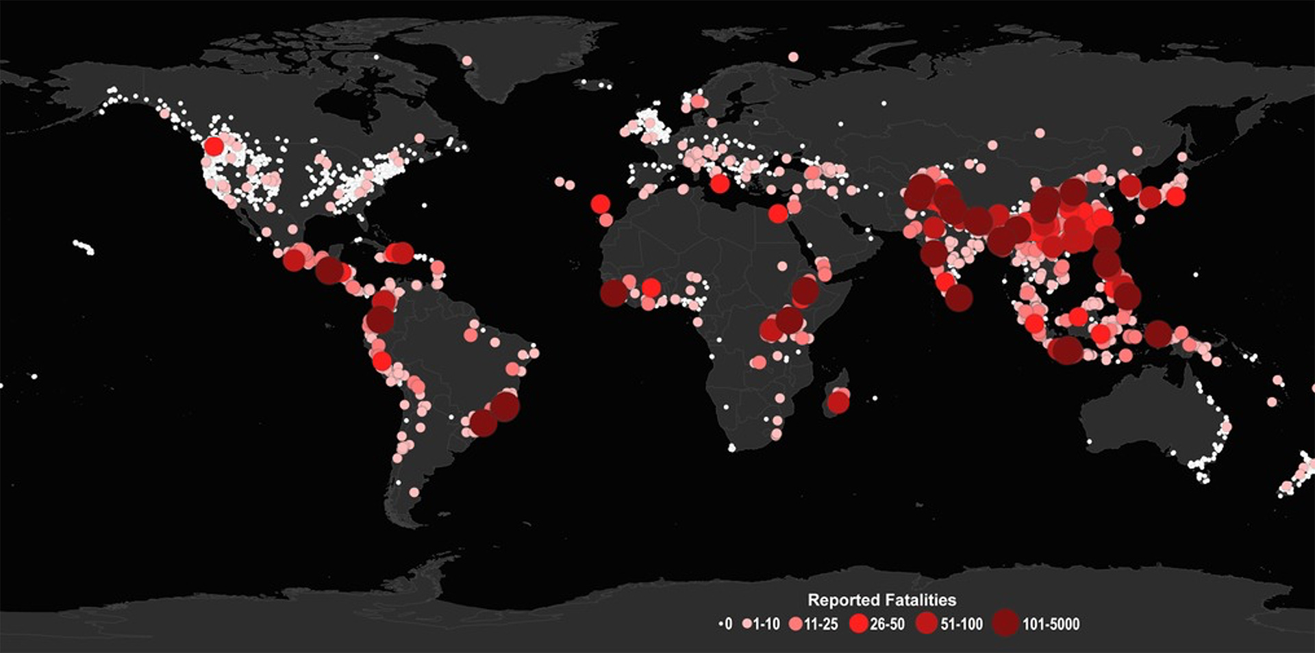
As I was reading this detailed analysis published by CarbonBrief on how Africa’s extreme weather has killed at least 15,000 people in 2023, I couldn’t help be astounded at the state of weather observations in the continent. Read the extract below, for understanding even finding basic rainfall data is impossible, even by using satellite data.
Kimutai led a team of scientists who tried to understand how climate change influenced the likelihood and severity of these floods.
However, the researchers were unable to carry out their analysis because they were not able to find reliable rainfall data from weather stations in the region.
She adds that the researchers also tried to use satellite information in the place of weather station data. However, data obtained from different satellites did not match up, making it impossible to tell exactly how much rainfall fell during the deadly flash floods.
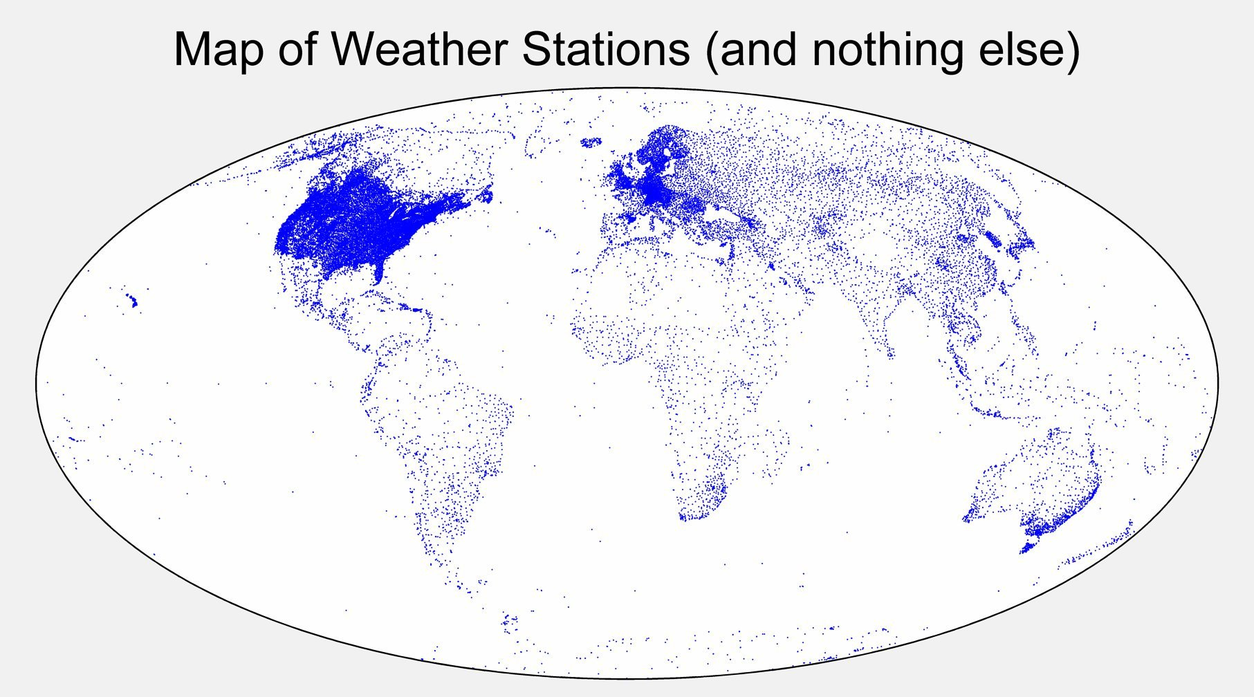
This should not come as a surprise for some of you, especially in the weather and climate community, or if you have read my weather deep-dive, as African extreme weather events often go “unreported” when compared to those in North America and Europe. This is primarily due to the lack of weather stations, which are crucial to not only keep weather records but also to support forecasting and early warning efforts.
There cannot be a more representative visual than the one below to convey the gaps in weather observations!
But, not having up-to-date records of weather events is not just an African problem … it is also the case in the US. Here is a figure to demonstrate the state of record-keeping in the US, from an NPR analysis.
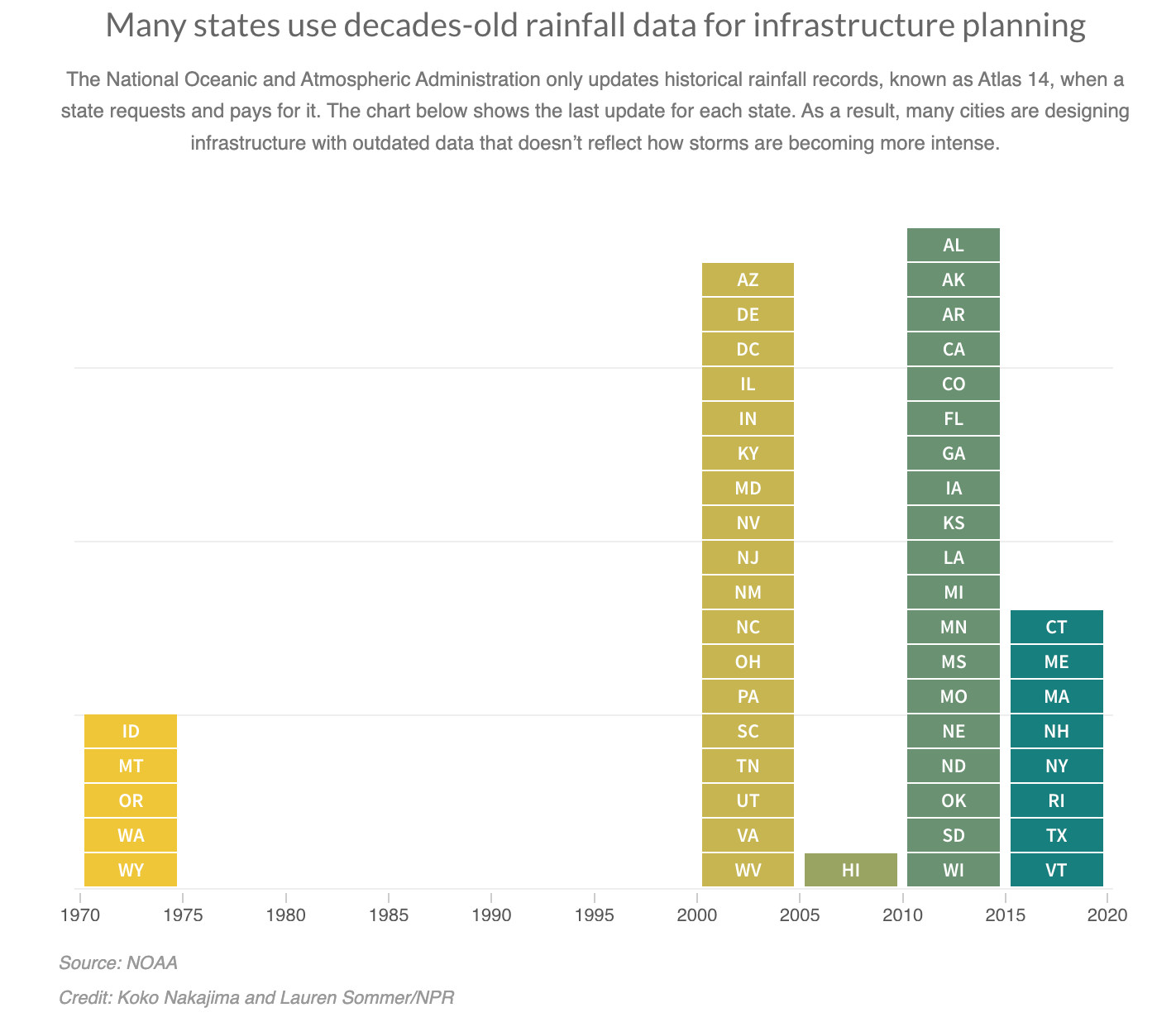
If you are wondering why it matters … Many states and cities are building and making decisions about their infrastructure, using rainfall records that haven't been updated in decades. So, roads will be flooded, bridges will be destroyed, and other critical infrastructure will be subject to extreme weather risks.
How do we fix this? There are certainly data gaps, which can partially be fixed with satellites with roles for stratospheric balloons, ocean buoys and yes, weather stations. But, there are also data assimilation and modelling gaps, as Hurricane Otis demonstrated, where there is certainly a role for AI. We have gotten better in understanding weather, but we have got a long way to go.
The amount of attention and media coverage that weather satellites get is inversely proportional to their societal, economic and environmental impacts on Earth, especially compared with the other segments of the space industry.
My wish? To not sweep this under the rug and actively work on fixing gaps in weather, as we are expecting several billion-dollar weather events around the world, due to climate change. This topic does not get the attention it deserves!
Scene from Space
One visual leveraging EO
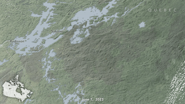
6. Canada’s Record-Breaking Wildfire Season
It seems like Canada’s record-breaking wildfire season could finally be coming to an end. About 45.7 million acres (18.5 million hectares) have burned in 2023, according to the Canadian Interagency Forest Fire Center, as of October 18.
Several of those fire events were continuously blazing over weeks, leading to huge swaths of areas burning down. The following animation from NASA’s Fire Events Data Suite, derived from NOAA and NASA satellite data collected day and night, showing the largest Canadian fire in the database - which had burnt 1,224,938 hectares or 4,730 square miles.
Until next time,
Aravind


