

Welcome to a new edition of ‘Last Week in Earth Observation’, containing a summary of major developments in EO from the last week and some exclusive analysis and insights from TerraWatch.
Four Curated Things
Major developments in EO from the past week
1. Contractual Stuff: Funding, Contracts and Deals 💰
Funding
- Macquarie Capital has invested in Earth Resources Technology, a technology consulting company that provides US Federal Government agencies with scientific and engineering consulting for EO missions;
Contracts
- ESA has awarded study contracts to consortiums led by Deimos and Open Cosmos, out of which one will be selected to build the eight satellites part of the Spanish component of the Atlantic Constellation;
- BAE Systems, formerly Ball Aerospace, won a $450M contract to develop an ocean-color instrument for NOAA’s GeoXO weather satellite;
- EO-based geospatial intelligence firm Preligens was awarded a contract for AI analytics on high-resolution satellite imagery by an APAC customer.
2. Strategic Stuff: Partnerships and Announcements 📈
Announcements
Indian EO startup GalaxEye Space announced that it has successfully tested its SAR payload on a high-altitude pseudo satellite platform;
EO platform startup SkyWatch announced today its new platform strategy and five new solutions to be released over 2024;
For more on EO platforms, check out the exclusive TerraWatch deep-dive;
Partnerships
- Planet expands its partnerships with ZEP-RE, an African reinsurance company and BASF Digital Farming, an agtech firm;
- European intergovernmental weather agency EUMETSAT signed a memorandum with the African Union Commission enabling access EUMETSAT’s data from its next-generation satellites.
3. Interesting Stuff: More News 🗞️
- NASA and IBM Research have developed a new AI foundational model to support a variety of weather and climate applications;
- SpaceX will launch on May 28 ESA’s EarthCARE mission, which includes four remote sensing instruments to monitor clouds and aerosols;
- The US government announced $6.6M in funding for a new Data Assimilation Consortium to improve weather forecasting;
- RocketLab launched the first cubesat of NASA’s PREFIRE mission aimed at measuring the infrared emissions at the poles to help climate modelling;
- SpaceX launched the first satellites for new US spy constellation with several more to follow in the year;
- China launched four high-resolution EO satellites as part of the Beijing-3C constellation providing 50cm panchromatic and 2m multispectral data;
- Space situational awareness data provider Privateer, which recently acquired Orbital Insight, wants to build the ‘Uber for satellite data’.
4. Click-Worthy Stuff: Check These Out 🔗
This article that presents NASA’s "Wildfire Digital Twin project to support firefighters for monitoring wildfires and predicting air pollution;
This piece that discusses the world's oceans are changing colour (from blue to green), leveraging EO data to show the impact of phytoplankton;
The recent edition of the Planet Snapshots newsletter, which looked into the growth of data centres from space (which will only keep growing with AI);
This timelapse shows Meta’s data centre in Prineville, Oregon, considered to be the company’s largest complex.
EO Summit: Last Few Tickets
EO Summit will have presentations from several organisations that include end-user organisations, analytics firms and EO satellite companies from sectors such as insurance & finance, agriculture & forestry, energy & utilities and carbon & nature-based solutions.
If you want to learn about the state of the EO market, the significance of EO for businesses and commercial use cases of EO, then you need to attend EO Summit.
Take advantage of the ongoing sale to buy your ticket with a 10% discount!
💸 Get 10% off with the code 'EOSUMMIT_SALE' untilMay 26May 31! 💸

One Discussion Point
Exclusive analysis and insights from TerraWatch
5. Categories of EO Users
The EO sector continues to suffer from a marketing and communication challenge, both in terms of spreading awareness of the value of EO by using the right language as well as positioning the right solutions in front of users, to solve their problems and get the job done. To solve this problem, it might help to identify the different persona of potential users of EO.
I believe that the end-users of EO fall into one of 3 categories, which I decided to simply call: Actively Looking, Passively Looking and Not Looking.
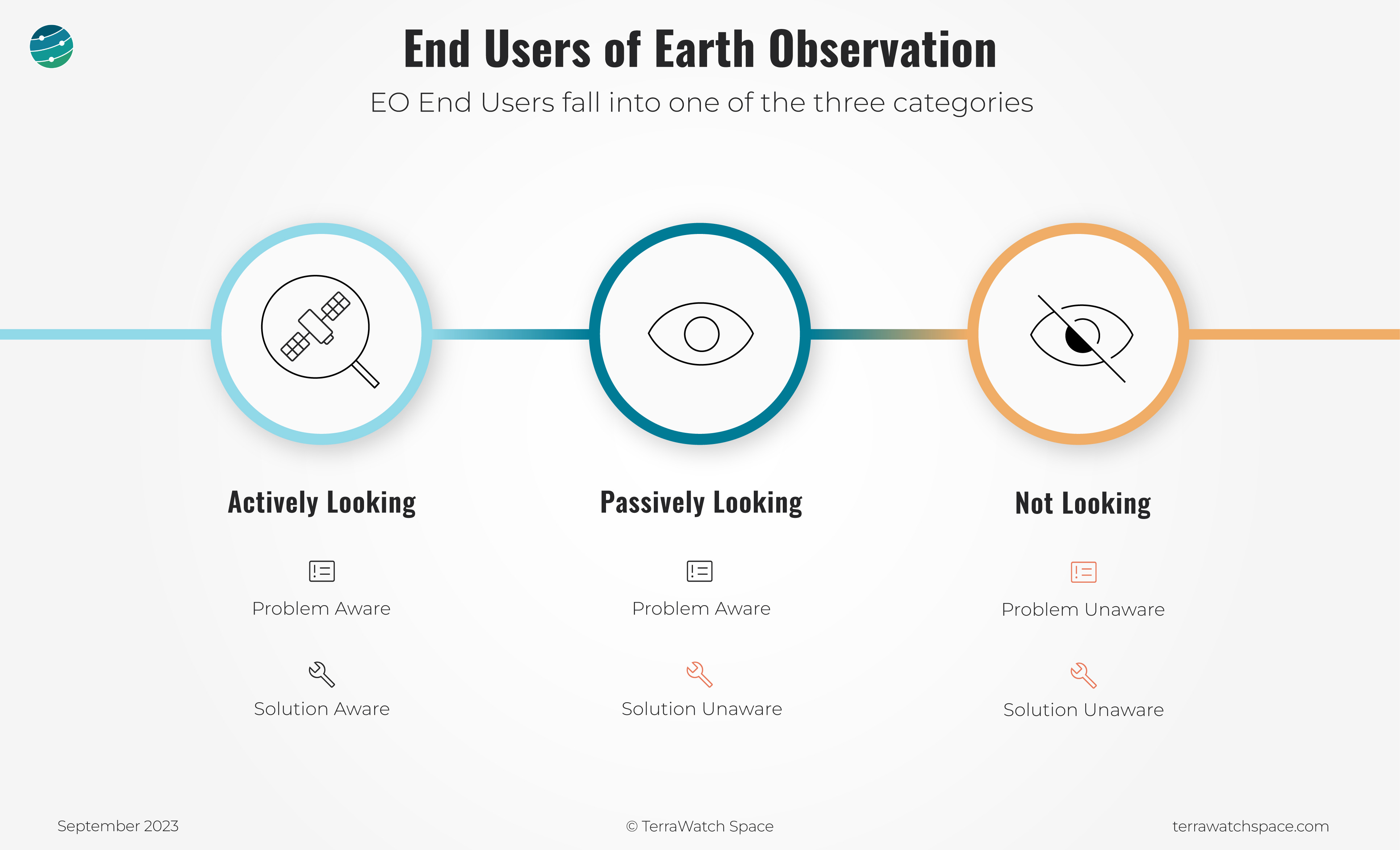
Those in the ‘Actively Looking’ category are both problem and solution aware. They know their problems and also know how EO can help solve them. They are interested in benchmarking different EO-based solutions, analysing the trade-offs and scaling the use of EO for solving their problems, in the immediate future. For them, it is about identifying the most efficient and effective way to integrate EO into their workflow and business processes to gain value.
Those in the ‘Passively Looking’ category are problem aware, but solution unaware. They know they have business problems that EO could help solve, but they don't know how. They need more EO evangelisation than simply EO marketing, as they could potentially adopt EO in the near future. For them, it is about communicating how EO is equally, if not, better than the existing methods they use to solve their problem, and how it can even complement what they do.
Those in the ‘Not Looking’ category are the hardest to sell to because they are not aware that they may have a business problem that EO could help them solve, as it is already being solved by other methods. They need more fundamental EO education and they might not adopt EO until well into the future. For them, it is just about understanding the fundamentals of EO and the potential applications of EO, without delving much into their use cases.
This is one of the methodologies we use at TerraWatch to develop go-to-market strategy and positioning models for EO and EO-enabled companies. Send me a note if you are looking for advice on commercial EO strategy.
A Note From a Gold Sponsor of EO Summit - Kuva Space
“Amidst the ongoing challenges posed by climate change, the need for accurate and timely information has never been more crucial. From food security to the reliability of voluntary carbon credit markets and geopolitical tensions, the demand for actionable insights is palpable.
Utilizing proprietary near real-time hyperspectral data captured from space and other data sources, Kuva Space employs advanced AI to generate actionable insights in areas such as crop yield forecast, biodiversity monitoring, blue carbon sequestration estimation, environmental health analysis, and marine surveillance.
Join us at the inaugural EO Summit, where we will discuss how our state-of-the-art hyperspectral solution is reshaping the traditional Earth observation paradigm. Our vision is to deliver industry-specific insights as-a-service, shortening the time-to-insights from days to a couple of hours, empowering our customers to make informed decisions swiftly and effectively.
In July 2024, Kuva Space will launch its Hyperfield-1, a hyperspectral microsatellite equipped with patented hyperspectral imaging technology. Our goal is to achieve a sub-daily revisit rate by the end of 2030 using a fleet of 100 satellites. In the second half of 2024, we are excitedly waiting to engage customers from various industries to join our Early Access Program, giving limited customers exclusive access to try out our services and collaborate on the development of new ones.
Sign up for our newsletter to get a personal invite for the beta platform in Q4 2024.”

Scene from Space
One visual leveraging EO
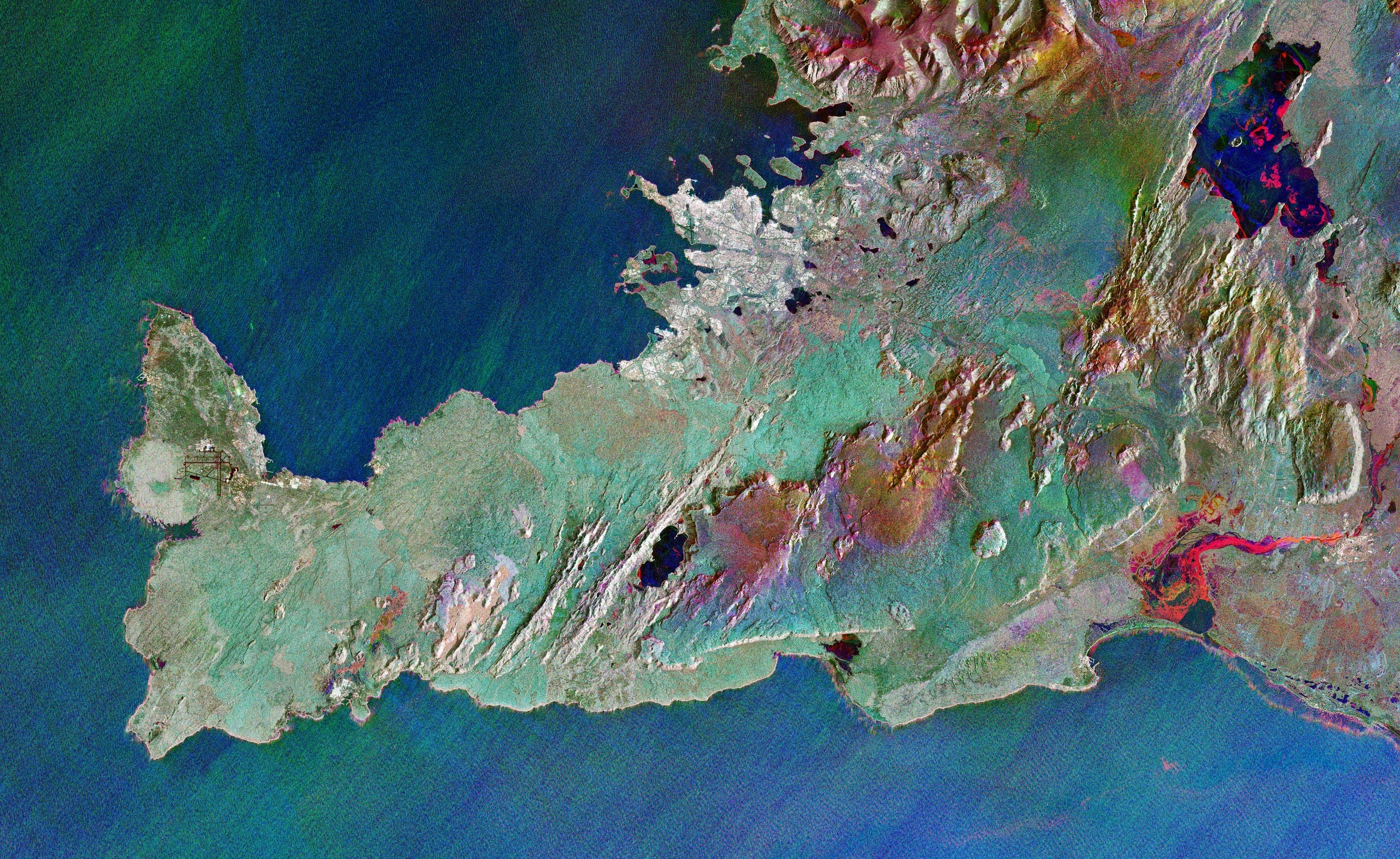
6. Monitoring Iceland Over Time with Multi-Temporal SAR
This false-colour image of Iceland's Reykjanes Peninsula, is actually made up of three satellite images over time captured by the Sentinel-1 satellite: red in January, green in February and blue in March. Some highlights:
- The predominant green of the February image denotes a lot of snow cover compared to the other months,
- Grindavik, a small town in the southwest of the country, which has been in the news due to the volcanic eruptions, can be identified with the small red areas representing the lava fields around the town,
- The various colours of the rivers and lakes suggest changes in the extent of ice on their surfaces.
So much can be inferred from an overlay of different satellite images - read more about the insights from this image on the ESA website.
This is a reader-supported publication. To receive exclusive deep-dives and support my work, consider becoming a paid subscriber.
Until next time,
Aravind.


