

Welcome to another edition of Earth Observation Essentials, the free biweekly newsletter from TerraWatch covering key highlights from the EO market along with exclusive insights and analysis.
If you would like a more detailed, comprehensive market briefing with exclusive analysis, delivered every week, become a Pro subscriber, or a Premium subscriber, for more deep dives on EO markets, technologies and applications.
📈 EO Market Highlights
Major developments in EO
🇨🇭 Switzerland has opted not to take part in the Copernicus programme in the coming years, citing budget constraints.
What's worth watching is the bigger question this raises: the financial sustainability of open data.
Copernicus is only getting more expensive from here: new Sentinel missions, more data to process and more investment in storage and dissemination.
All of it will be funded by the countries in Copernicus. So if other countries reach the same conclusion that Switzerland has - that open access makes paying in optional - there will be questions about the willingness of contributors to keep funding something others can use for free, or more importantly, to continue today's open data policies for non-members.
💰 French startup Vortex-io raised an €8.5M Series A funding round to continue building its in-situ hydrological observation solutions for river flood monitoring – essentially used to calibrate and validate data from major EO missions like SWOT, Sentinel-3 and Sentinel-6.
🇪🇺 The European Commission adopted a new initiative, OceanEye, to expand EU's role in ocean observation, with goals to contribute to 35% of the global ocean observing system by 2035.
Europe already leads globally in space-based observation via Copernicus, perhaps OceanEye is a bet that the same playbook could also work for the ocean domain.
In the TerraWatch Pro newsletter last week, I wrote about Traditional vs AI Weather Models: The Role of Satellite Data, especially the differences between NWP and AI models and how satellite data is a common factor.
Upgrade to a Pro subscription for just $75 per year to check out the analysis and receive weekly exclusive market briefings.
💡 Insight Bytes
A quick dose of analysis from TerraWatch
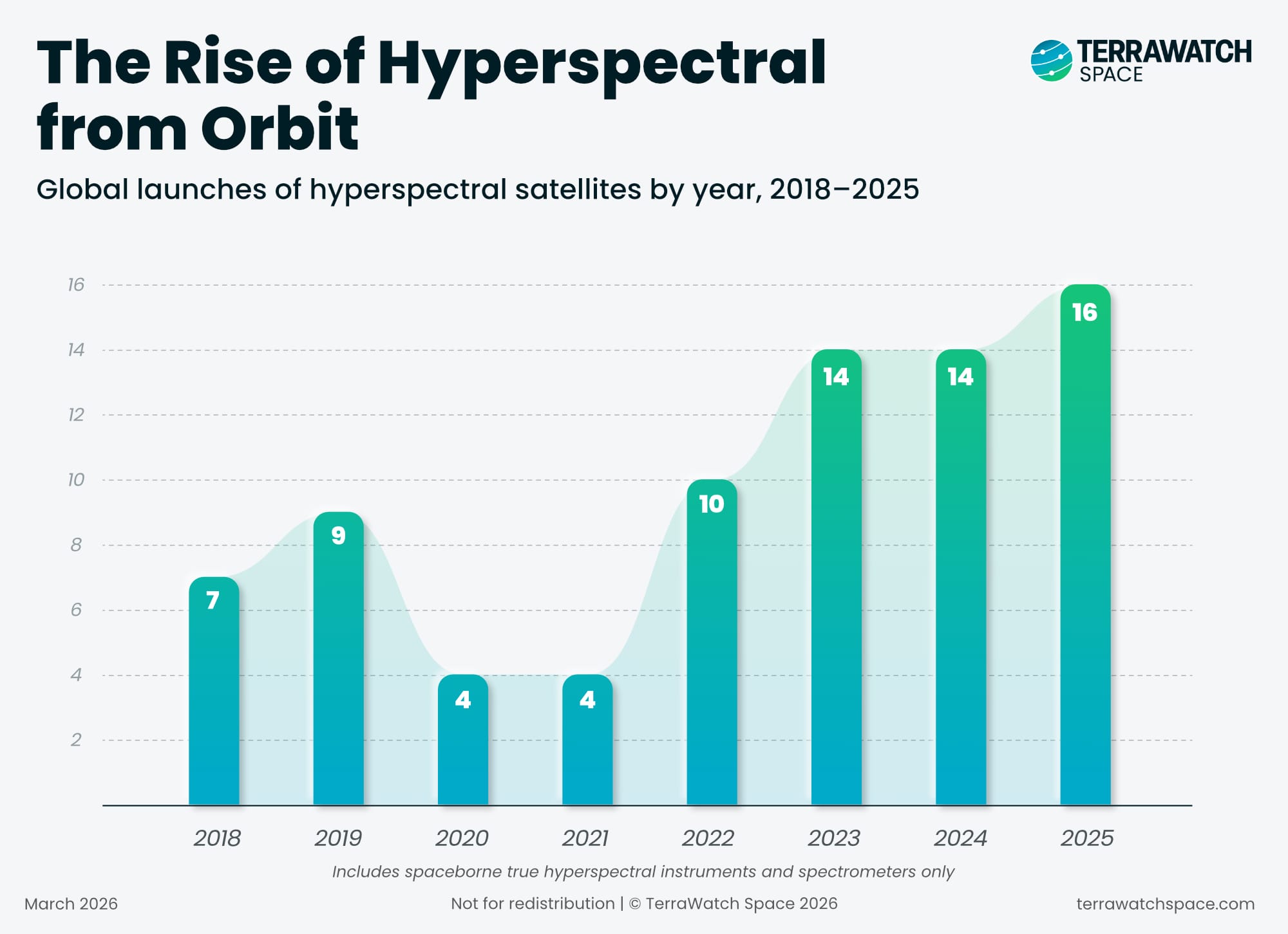
The Hyperspectral Imagery Boom
The 2018–2025 period marks a clear shift for hyperspectral EO from sporadic demonstration missions to a more sustained wave of launches. What used to be a relatively thin category is now far more active, with a mix of public and commercial missions expanding the field across Asia, Europe, North America, and beyond.
The list now includes established public missions such as HysIS, PRISMA, and EnMAP, a growing set of Chinese missions including Zhuhai-1 OHS, HJ-2A/B, Jilin-1, and a rising number of private sector companies such as Orbital Sidekick, Planet, Wyvern, Pixxel, Esper, Kuva Space, Matter Intelligence and more. In other words, hyperspectral is no longer limited to a handful of research and technology demonstration missions - it is becoming a real segment of the EO market.
Hyperspectral is finally moving toward operationalisation with greater continuity, more frequent revisit, and a broader mix of operators. For years, one of the constraints on hyperspectral EO was simply the lack of enough satellites in orbit, but that is beginning to change.
Why The Hyperspectral Wave Is Different from SAR
It might be tempting to compare the evolution of hyperspectral to SAR, when Sentinel-1 launched followed by several commercial radar satellites. However, one key difference between the NewSpace SAR wave and the emerging hyperspectral wave is the foundation each one inherited.
SAR had a major advantage: open data had already been available for years, especially through Sentinel-1. That helped create an ecosystem of preprocessing tools, processing workflows, and fusion methods long before many commercial SAR companies began scaling. Just as importantly, dozens of analytics companies were able to build on top of that foundation and demonstrate high-value use cases early. By the time commercial SAR constellations arrived, the market already had proof points.
Hyperspectral is different. While there have been important missions such as EO-1, PROBA, PRISMA, and EnMAP, there has not been a hyperspectral equivalent of Sentinel or Landsat at the scale needed to broadly seed tooling, workflows, and familiarity across the EO ecosystem.
That makes the data challenge heavier. Hyperspectral data is richer, more complex, and more demanding to process than most optical imagery, and the surrounding support stack at satellite scale is still less mature than what SAR companies inherited. The result is that hyperspectral companies must do more of the groundwork themselves: not just launching satellites, but helping build the processing layer and proving where the sensor delivers real value.
The good news might be that hyperspectral is not new as a sensing modality. Airborne and drone-based hyperspectral data has been used for decades across sectors from agriculture to surveillance to biotech. But at satellite scale, much of the enabling layer still has to be built. This is what makes this next phase so important and probably makes the launch of Copernicus CHIME in 2028 an critical milestone for the growth of this segment.
EO Summit: Last Week to Buy Tickets
The 3rd edition of EO Summit is coming up in 2 weeks – if you would like to join us on June 22, then hurry up and reserve your tickets now!
We have an amazing line-up of speakers from some incredible organisations across several sectors. Check out the agenda here.

🔍 Recommended Reads
Interesting links to check out
- This article on the Tessera EO foundation model useful for building crop intelligence and forest monitoring applications.
- Analysis of high-resolution imagery from Airbus showed that Iran damaged over 20 US military sites since the start of the war, suggesting the attacks are more extensive than publicly acknowledged.
- Planet's CEO Will Marshall published a strategic essay that introduced the concept of "Planetary Intelligence", signalling a potential future for Planet towards building Large Earth Models derived from its imagery.
Combining sensing with AI yields Large Earth Models (LEMs) — the LLM analogue, able to answer specific real-time questions about what's actually happening on Earth. This capability, he terms as Planetary Intelligence, has applications across security, sustainability, disaster response, insurance and governance.
🛰️ Scene from Space
One visual leveraging EO
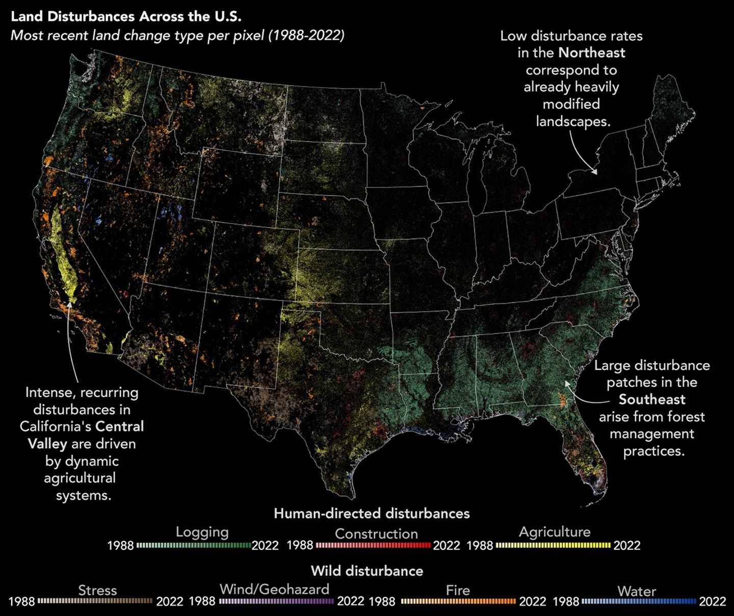
Changing Landscape in the US
An analysis of Landsat imagery of the past four decades is showing that while humans have dominated changes to the landscape in the US, disasters such as wildfires, wildfires, hurricanes, and landslides are starting to have a huge effect on land disturbances across the country.
Until next time,
Aravind.


