

Welcome to a belated edition of Earth Observation Essentials, the free biweekly newsletter from TerraWatch covering key highlights from the EO market along with exclusive insights and analysis.
If you would like a more detailed, comprehensive market briefing with exclusive analysis, delivered every week, become a Pro subscriber, or a Premium subscriber, for more deep dives on EO markets, technologies and applications.
📈 EO Market Highlights
Major developments in EO
🛰 NASA selected 8 additional commercial EO data providers for the Commercial Satellite Data Acquisition program that will join the 16 other providers already contracted to be part of the $476M contract. The selected providers include Hydrosat, OroraTech, ImageSat, Satlantis, Kuva Space, Wyvern, Orbital Sidekick an Muon Space.
📈 Financial intelligence firm MSCI is acquiring First Street, a climate risk modelling provider for $120M in cash.
As banks and insurers start pricing homes, loans and portfolios off these private verdicts, the market comes to rely on models it cannot inspect. It looks like this unauditable closed layer is becoming the standard everyone trusts - with no way to question it and no public fallback if it is flawed.
🔥 Bezos Earth Fund announced a $26M investment in non-profit Earth Fire Alliance, the organisation that is building a purpose-built satellite constellation for global wildfire detection.
🛡️ Insurance firm Liberty and ICEYE announced the launch of a new building-level parametric wildfire insurance solution.
- Related: This validates the thesis we laid out on in our exclusive deep-dive on the potential for EO in parametric insurance applications.
💰 ICEYE raised €450M in a Series F funding round at a valuation of over €10 billion (called a decacorn). This, in addition to a secondary placement put the overall fundraising amount for this round to a whopping €1B. The company reported €250M in revenues in 2025, with over €100M in operating profits, and a contracted backlog of over €1.5B.
In the TerraWatch Pro newsletter last week, I wrote about the journey of how ICEYE became a decacorn and how their strategic decisions led them to where they are today.
Upgrade to a Pro subscription for just $75 per year to check out the analysis and receive weekly exclusive market briefings.
💡 Insight Bytes
A quick dose of analysis from TerraWatch
The following insight brief is part of the TerraWatch Pro newsletter provided here as a preview for free subscribers. For receive weekly exclusive insights and analysis, become a Pro subscriber.
Why China's Banks Are Launching Their Own Earth Observation Satellites
China's banking sector is building EO capabilities from the demand side, at a pace that has no equivalent anywhere else in the world.
What's Happening
Since 2020, four Chinese banks have launched their own satellites, though not all are imaging satellites.
- Ping An Bank launched IoT satellites PingAn-1 (2020) and PingAn-2 (2022) for ground-based data collection, followed by PingAn-3 in August 2022 — its first optical EO satellite, built by Minospace.
- China Merchants Bank and Shanghai Pufa Bank both launched satellites into the Tianqi IoT constellation in January 2026 – narrowband connectivity satellites that connect to ground sensors on construction sites, warehouses, and farms rather than imaging from orbit.
- The Postal Savings Bank of China launched an imaging satellite in April 2026, jointly developed with Changguang Satellite Technology — part of the Jilin-1 constellation, with 0.5m resolution and onboard AI-assisted processing.
Beyond those four, several more have integrated satellite remote sensing into their credit risk operations without launching their own hardware.
- MYbank built a remote sensing-based agricultural credit system called "Great Tit" that uses AI to analyse satellite imagery of crop conditions.
- Industrial and Commercial Bank of China, Bank of China, Industrial Bank, and Shanghai Rural Commercial Bank are all using satellite remote sensing for post-loan management — procuring data from operators like Changguang Satellite Technology rather than building their own.
The Use Cases
The use cases are specific and tied directly to credit decisions. Some examples are provided below, but as I mentioned in the EO Adoption Hype Cycle analysis, these are not new use cases.
- Real estate post-loan monitoring: Banks monitor construction sites to verify developers are actually building what they borrowed money for. Some developers figured out inspection schedules and would only work one or two days before the bank's visit. Satellite monitoring eliminates that game.
- Agricultural credit: Tracking crop health, planting area, and livestock numbers in remote areas where on-site inspections are infrequent and unreliable. MYbank's system estimates crop yields and expected market values to determine credit limits for farmers.
- Supply chain and trade finance: Watching warehouse inventories and cargo ship movements, triggering early warnings when collateral conditions change or deliveries stall.
What this tells us about commercial EO adoption in China
The Western EO industry has spent years trying to crack the commercial market from the supply side: build better satellites, develop analytics platforms, find domain partners to bridge the gap between the data and the buyer. The underlying assumption is that commercial customers don't know what to do with EO data on their own, so someone has to translate it for them.
China's banks have inverted this entirely. The domain expert i.e., the bank, is pulling EO capability toward itself rather than waiting for the EO industry to push it. Some are launching their own satellites. Others are procuring data from Chinese satellite operators and building internal analytics. Either way, the bank defines the use case, controls the data pipeline, and integrates the output directly into its own risk systems (no intermediary needed).
This works because the use cases are operationally concrete. A bank doesn't need a general-purpose analytics platform. It needs to know whether a construction site is active, whether crops are healthy, whether a warehouse is full. These are binary or near-binary questions with direct financial consequences – exactly the kind of EO application that converts, as the Orbital Eye-Enagás pipeline monitoring example above also demonstrates.
The scale is also striking. Some reporting suggests that the internal debate inside Chinese banks is no longer whether satellite remote sensing works for credit risk, but whether to buy data, lease a satellite, or launch one. One bank set a threshold: the satellite investment must reduce annual bad debts by 200 million yuan to justify tens of millions in costs. That is the kind of ROI framework that the Western EO industry rarely encounters from commercial buyers, because Western buyers are rarely this operationally specific about what they need.
The broader implication
China may be building the largest commercial EO user base in the world — not through the supply-side model the Western industry has pursued for two decades, but through demand-side pull from institutions that already know exactly what they want from satellite data.
If this scales, and the trajectory since 2020 suggests it will, it has implications for who shapes the commercial EO market globally. The Western EO industry is still trying to convince commercial buyers to adopt, while China's commercial buyers are already building.
🔍 Recommended Reads
Interesting links to check out
- This piece that provides an overview of the conversations that happened at the EO Summit.
- Google open-sourced their hydrology model to enable National Meteorological and Hydrological Services to integrate advanced AI-based flood forecasting into their own workflows.
- Switzerland’s decision not to participate in the Copernicus program during the 2028–2034 funding cycle has revived a broader debate over the value of contributing to the imagery program when much of its data remains freely available worldwide.
- This piece that discusses how satellite data is increasingly becoming a key component of economic monitoring globally.
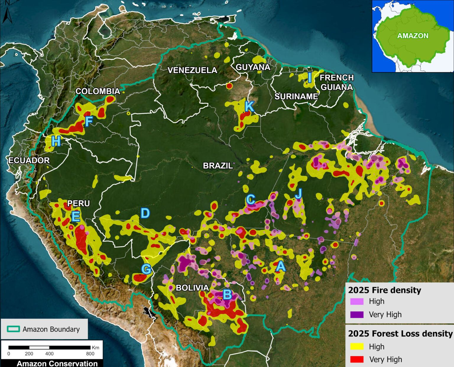
- Analysis of deforestation in the Amazon has shown that while deforestation has reduced in 2025, there is an increasing risk of fires due to the changing climate.
🛰️ Scene from Space
One visual leveraging EO
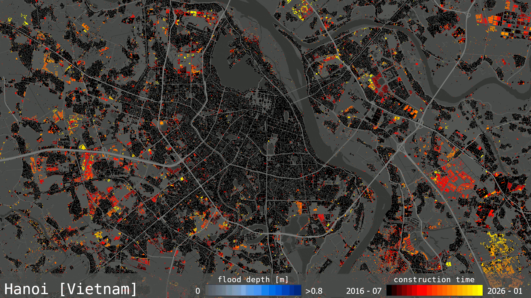
Tracking urban growth and hazards
ESA launched a new platform, World Settlement Footprint (WSF) Tracker, which allows for users to get a continuous understanding of how cities and settlements evolve as well as overlay hazard risks over the changing area.
The platform provides these insights at 10m resolution and every six months based on satellite data from Sentinel missions.
The animation from ESA shows construction over the past decade in Hanoi, Vietnam – with new buildings shown in black, red, orange and yellow (most recent), along with the potential flood risk in the city. You can see that much of the new urban expansion is happening in areas with risk of deepest flooding.
Until next time,
Aravind.


