


Welcome to a new edition of Earth Observation Essentials, the free biweekly newsletter from TerraWatch covering key highlights from the EO market along with exclusive insights and analysis.
If you would like a more detailed, comprehensive market briefing with exclusive analysis, delivered every week, become a Pro subscriber, or a Premium subscriber, for more deep dives on EO markets, technologies and applications.
📈 EO Market Highlights
Major developments in EO
- Real estate data provider CoStar Group is acquiring aerial imagery provider Vexcel for $730M, adding high-resolution imagery covering over 45 countries to expand its property intelligence and AI capabilities.
This is also a good validation of the trend I have written about: vertical leaders are more likely to consider geospatial a strategic asset and acquire their own data infrastructure to differentiate their products.
- NASA and the US Department of Agriculture have expanded their partnership to integrate satellite data into agricultural monitoring, improving crop acreage and yield estimates, drought assessments and the use of EO in agricultural decision-making.
- NASA has awarded $15.9M to extend the GEDI spaceborne LiDAR mission through October 2029, continuing its unique measurements of forest canopy structure and biomass for applications including carbon monitoring, forestry and conservation
- Google DeepMind has released two datasets used to develop its AI weather models: SatWeave, combining global geostationary satellite imagery, and PARDIG, providing AI-derived precipitation estimates at approximately 10 km resolution every 15 minutes.
In this specific case, the exciting possibility is that since the underlying datasets are released, anyone can now develop their own AI models and applications without recreating the data infrastructure from scratch - across parametric insurance, catastrophe modelling, solar power forecasting, hydropower, irrigation, drought management etc.
- Kazakhstan is developing a national satellite-based methane programme, integrating commercial and public satellite observations into government monitoring of oil and gas facilities, with detections intended to trigger operator investigations, repairs and verification.
In a recent edition of the Pro newsletter, I analysed the benefits of an application-focused sovereign EO initiative, like that of Kazakhstan's, and what it means for the EO sector.
Upgrade to a Pro subscription for just $75 per year to check out the analysis and receive weekly exclusive market briefings.
💡 Insight Bytes
A quick dose of analysis from TerraWatch
The following insight brief is part of the TerraWatch Pro newsletter and included here as a preview for free subscribers. To receive weekly exclusive insights and analysis, become a Pro subscriber at only $75 per year.
Decision-Ready Earth Observation is a Buzzword in the Age of AI, but is your EO Solution Really Decision-Ready?
As awareness and adoption of EO increases, it is starting to be increasingly used for more than just monitoring, it is actually now being used in actual decision making across enterprise and government level. From identifying pollution and assessing deforestation to determining insurance payouts and prioritising investments, EO-based information is becoming part of how organisations make decisions with real financial, regulatory and operational consequences.
But, there is a big difference between using EO to help inform a decision and relying on EO to determine an outcome.
As the industry increasingly markets decision-ready intelligence, I think we need to look more closely at what this actually means, particularly when the information is incomplete, uncertain or disputed.
From Detection to Decision: The 4 Stages of Decision-Ready EO
A useful way to think about this is to break down the journey from satellite observations to decisions into four stages:
Identifying whether something exists or has occurred, such as a methane plume, an oil spill or forest clearing.
2. Measurement (how much?)
Quantifying what has been detected, including its magnitude, extent, frequency or change over time.
3. Attribution (what caused it, or who is responsible?)
Establishing where an observation comes from or what caused it, often requiring additional information beyond satellite data.
4. Decision (what should we do about it?)
Determining what action to take based on the evidence, whether investigating an incident, paying compensation or imposing a penalty.
The first three stages are about what EO can help establish, while the fourth is what a company, regulator or other user decides to do with that information. Needless to say, not every application requires all three steps, and verification/validation matter throughout.
Remember that detection with a good instrument does not automatically mean a reliable measurement and even accurate attribution may not necessarily justify a particular decision.
For example, a recent Stanford-led study of methane-monitoring satellites found that dedicated instruments detected 92–100% of controlled methane releases under clear skies, while estimates of emission quantities had a mean absolute percentage error of 44%. In other words, this level of performance could be sufficient to identify leaks for investigation and repair, but it raises different questions when the information is used to calculate emissions-related financial liabilities.
The Consequences Of Getting It Wrong
Talking about the standards of what level an EO product should reach is not an easy one – in reality, the standard should depend not just on the accuracy of an EO product, but also on what happens when the resulting decision is wrong.
Consider SkyTruth's Cerulean, which identifies potential oil slicks and associates them with nearby vessels and offshore infrastructure. These associations can support further investigation, but SkyTruth explicitly cautions against treating them as definitive evidence of responsibility.
Similarly, Google's recently launched forest classification dataset achieves 90% accuracy in classifying forest types globally, while providing probability scores that allow users to choose different confidence thresholds. A conservation organisation screening for potential deforestation and a company determining whether a supplier meets regulatory requirements might reasonably apply different thresholds to the same information.
But who decides how much uncertainty is acceptable, and who bears the consequences when that judgement is wrong?
The controversy surrounding satellite-based pasture insurance in France illustrates this challenge. Even if the underlying index is generally reliable, discrepancies between estimated pasture production and farmers' actual experiences can affect compensation.
So, we should not be always discussing whether the satellite data or model is accurate. Our focus should be whether the EO-derived information actually represents what the decision is supposed to establish.
What Does This Mean for Companies Offering EO-Based Products?
This discussion has and will continue to have implications for how EO solutions are developed, sold and integrated into operational workflows – especially in a world where they will be done via AI.
EO providers are already using AI to automate detection, measurement and certain forms of attribution. But using this information for decisions often requires domain knowledge, additional evidence and judgements about acceptable risk. However, relying on manual verification for every decision could undermine the scalability and economic advantages of EO-based solutions.
The opportunity might be to develop workflows that distinguish between decisions that can be automated, those requiring additional verification and those that should remain subject to expert judgement, with mechanisms to challenge and correct outcomes.
As the industry evolves, the most important thing we need to figure out is the difference between when EO evidence is sufficient to trigger an action automatically and when it may not be sufficient on its own to justify a final decision.
As EO becomes embedded in more consequential processes across industries, defining that boundary, and establishing who is responsible for it, could become an increasingly important part of the value proposition for this technology.
🔍 Recommended Reads
Interesting links to check out
- A New York Times opinion argues that US government pressure on commercial satellite imagery providers, including Planet and Vantor, has restricted access to imagery of conflict zones in the Middle East.
- An audit of 152 geospatial foundation model research papers by Taylor Geospatial found major problems with model evaluation and reproducibility, making meaningful comparisons between models extremely difficult.
- Florida has sued climate-risk analytics company First Street, alleging that its property-level flood, wildfire and other climate-risk scores are misleading and negatively affect property values and insurance costs.
- This article that summarises the scientific roadmap for the Earth Fire Alliance's FireSat constellation outlining how high-resolution thermal data could improve wildfire monitoring beyond early detection, including measuring emissions from small fires, forecasting smoke exposure and assessing ecosystem damage.
🛰️ Scene from Space
One visual leveraging EO
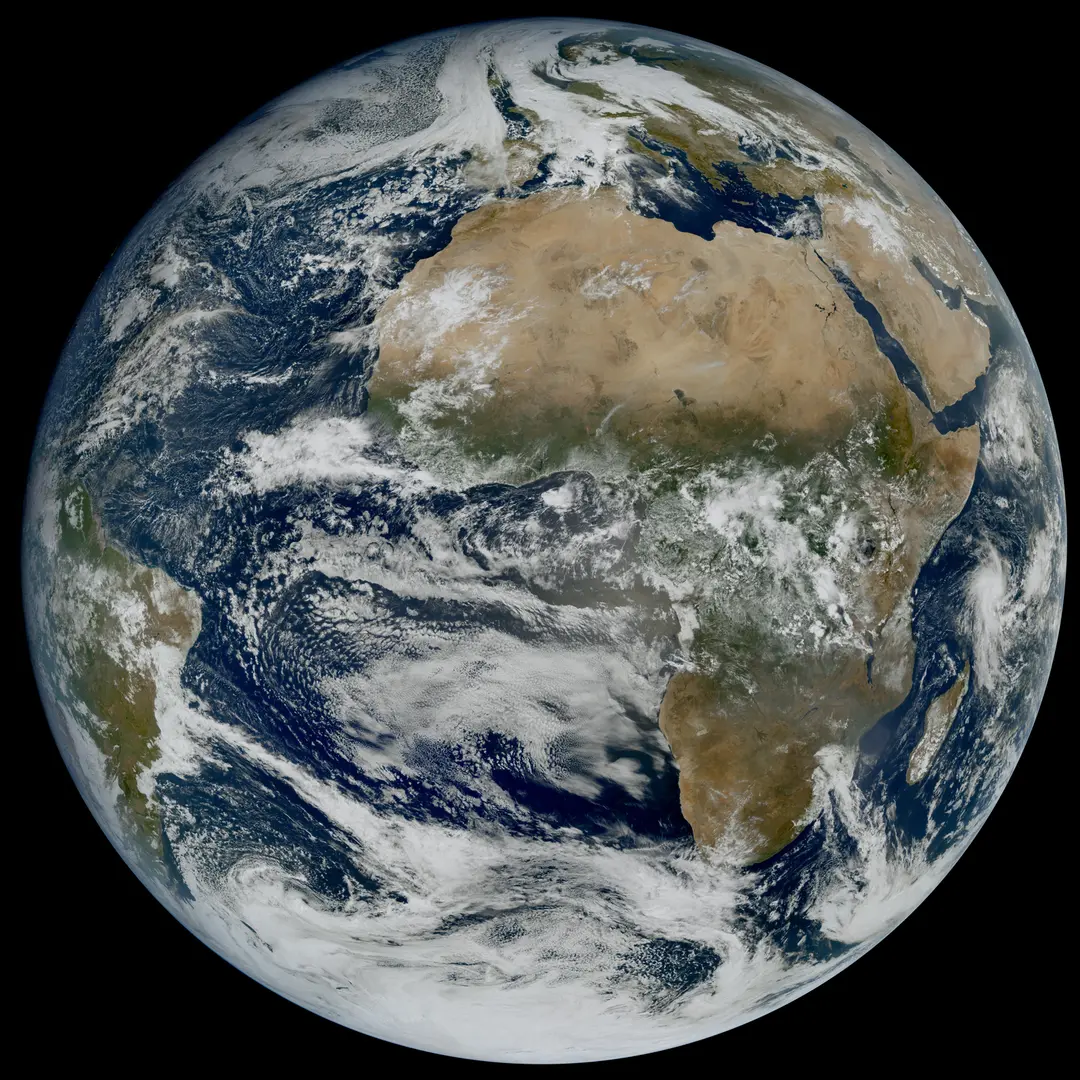
Meteosat Third Generation (MTG) I2's First Images
The Meteosat Third Generation (MTG) mission’s second Imager satellite has delivered its first images. In the rapid scan mode, the satellite can provide data over Europe and North Africa every 2.5 minutes, which is a game-changer for weather forecasting, especially for nowcasting applications.
Until next time,
Aravind.


