


Welcome to a new edition of Earth Observation Essentials, the free biweekly newsletter from TerraWatch covering key highlights from the EO market along with exclusive insights and analysis.
If you would like a more detailed, comprehensive market briefing with exclusive analysis, delivered every week, become a Pro subscriber, or a Premium subscriber, for more deep dives on EO markets, technologies and applications.
📈 EO Market Highlights
Major developments in EO
- A new US Government Accountability Office report warns that cuts to NOAA’s next-generation GeoXO weather satellite programme – reducing it from six satellites to four and dropping three planned instruments — could create gaps in geostationary weather monitoring and potentially weaken future forecasting capabilities.
Commercial weather companies can increasingly supplement NOAA in areas such as microwave sounding, radio occultation and imagery. NOAA is already buying or testing data from companies such as Tomorrow.io, Spire, PlanetiQ, Muon Space, Weather Stream and several others through its new $2.35B vehicle (we analysed this in-depth weeks ago in a Pro weekly edition).
But the fact is that are no equivalent commercial replacements today for continuous geostationary lightning mapping, hourly atmospheric-composition monitoring or high-frequency ocean-colour observations.
In other words, these cuts cannot simply be offset through commercial procurement: they risk leaving genuine observation gaps in severe-weather warnings, wildfire-smoke and air-quality monitoring, and coastal/ocean hazards.
- Czech defence group CSG acquired a 9.5% stake in Canadian space firm MDA Space for around $440M, becoming its largest shareholder and laying the groundwork for cooperation on European production, M&A and defence sales.
- ICEYE and OroraTech announced a partnership to combine OroraTech’s thermal wildfire detection with ICEYE’s radar-based damage assessment, creating a single service that can follow a wildfire from early detection and fire-front progression through to impacts on buildings and infrastructure.
Their overall positioning as a satellite-based solution to a problem is actually improved by joining forces rather than wrongly assuming they are cannibalising each other's markets.
We will be seeing more such partnerships between EO companies, eventually leading to acquisitions for sensor diversification.
In a recent edition of the Pro newsletter, I analysed the 10 different layers of Earth observation sovereignty and what this means for the future of EO.
Upgrade to a Pro subscription for just $75 per year to check out the analysis and receive weekly exclusive market briefings.
💡 Insight Bytes
A quick dose of analysis from TerraWatch
The following insight brief is part of the TerraWatch Pro newsletter and included here as a preview for free subscribers. To receive weekly exclusive insights and analysis, become a Pro subscriber at only $75 per year.
The Future of the Thermal EO Market: Analysing the Strategies of Hydrosat, Constellr and SatVu
Hydrosat’s recently announced a upgrade to its thermal constellation – constellr and SatVu also had recent milestones. So, it is perhaps a good time to look at the commercial thermal EO market, which, I think, is becoming a pretty broad category.
The short story is that the 3 companies are increasingly optimising for very different customer problems, the long story follows.
Three Different Bets on Thermal
First, let me refresh your memories on what the three companies are actually working on and what their roadmaps are.
- Hydrosat – Optimizing for Coverage: Today, Hydrosat delivers thermal LWIR imagery at 70 m resolution over a 70 km swath. Their new constellation Osiris pushes that down to 25 m across a 160–340 km swath, alongside 10 m multispectral data. This a major step towards persistent thermal monitoring across large agricultural, water, infrastructure and security areas.
The value comes from covering more territory, more often, rather than extracting the maximum detail from any one asset.
- SatVu – Optimizing for Activity: SatVu's HotSat satellites provide MWIR imagery at 3.5 m resolution, over much smaller scenes. This means their product is particularly suited to identifying whether individual facilities, industrial processes or other assets are active, idle or changing over time – otherwise called activity detection.
The addressable area is smaller, but the value of each observation can be much higher – similar to a very high-resolution image.
- Constellr – Optimizing for Precision: Their current constellation delivers 30 m thermal measurements, while its next generation is supposedly targeting sub-5 m resolution. The company, which was founded for the agriculture sector, is now increasingly positioning thermal as a defence and intelligence layer for understanding activity at specific assets and strategic sites.
If it can retain measurement quality while increasing spatial detail, constellr could offer something different from simply detecting thermal activity: precise temperature-driven intelligence at asset scale.
What This Means for Commercial Thermal EO
The roadmaps of these companies means that thermal’s role could evolve and how it co-exists with optical and SAR. Wide-area thermal can act as another monitoring layer across regions, while high-resolution thermal can add behavioural or operational context to assets already identified through other sensors.
This makes the question more interesting than simply who has the highest thermal resolution or widest swath. My thesis is that thermal EO could develop as several adjacent markets rather than converge around one dominant product: persistent regional monitoring, precise temperature-drive intelligence or asset-level activity detection.
So, instead of asking whether anyone is ready to pay for thermal (they will), we should be asking which kind of thermal intelligence supports enough recurring demand to justify a constellation-scale investment. Hydrosat, constellr and SatVu are now making three different bets on that, but I think the market may prove large enough for all three rather than converge around a one thermal winner.
If you would like to receive weekly market briefings with exclusive insights and analysis, upgrade to a Pro subscription.
🔍 Recommended Reads
Interesting links to check out
- The Allen Institute for AI has released the latest version of OlmoEarth, an open-source geospatial foundation model, with global embeddings at 10 m resolution.
- Google DeepMind has released ForTy, an open global 10 m forest classification dataset using AlphaEarth satellite embeddings to distinguish natural forests, plantations and tree crops supporting deforestation monitoring initiatives.
- ECMWF has made its 9 km medium-range weather forecast data free and open, enabling more localised forecasts.
- The accuracy of methane emission satellites was validated through a Stanford-led year-long blind test of in which dedicated methane satellites detected 92–100% of leaks in clear conditions compared with weaker performance from general-purpose EO satellites
- Brazil’s space research agency INPE announced that deforestation in Brazil’s Amazon rainforest has fallen to its lowest level since records began in 1988, ahead of a key presidential election coming up.
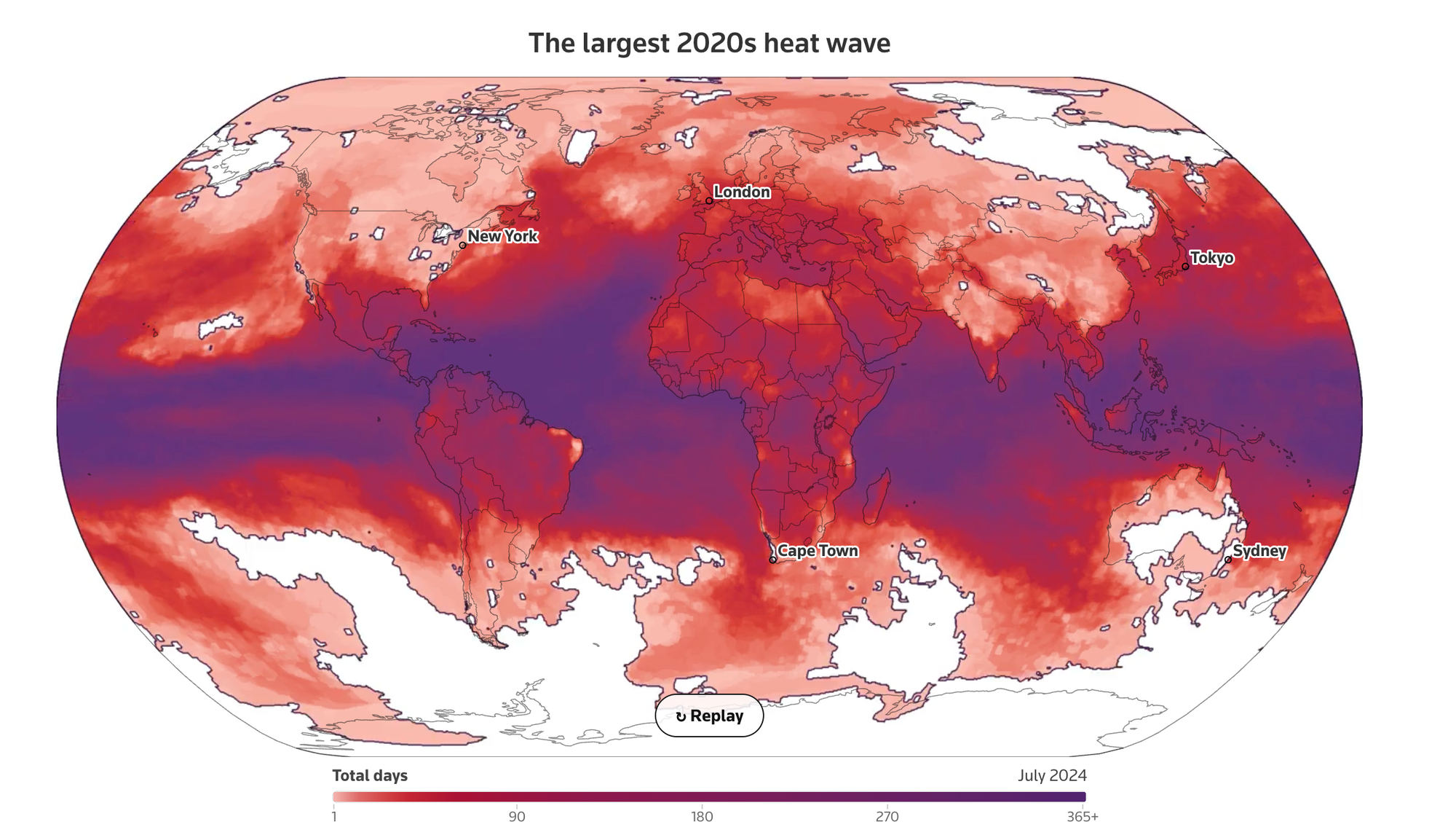
- Reuters used ECMWF’s ERA5 climate data to map and analyse ‘heat storms’ globally, finding that such events have increased from around five annually in the 1960s to over 100 this decade, with the largest on record lasting 367 days and affecting nearly 85% of the planet over its lifetime.
🛰️ Scene from Space
One visual leveraging EO
Google Illegally Cuts Over 250,000 Trees for Data Centre in Finland
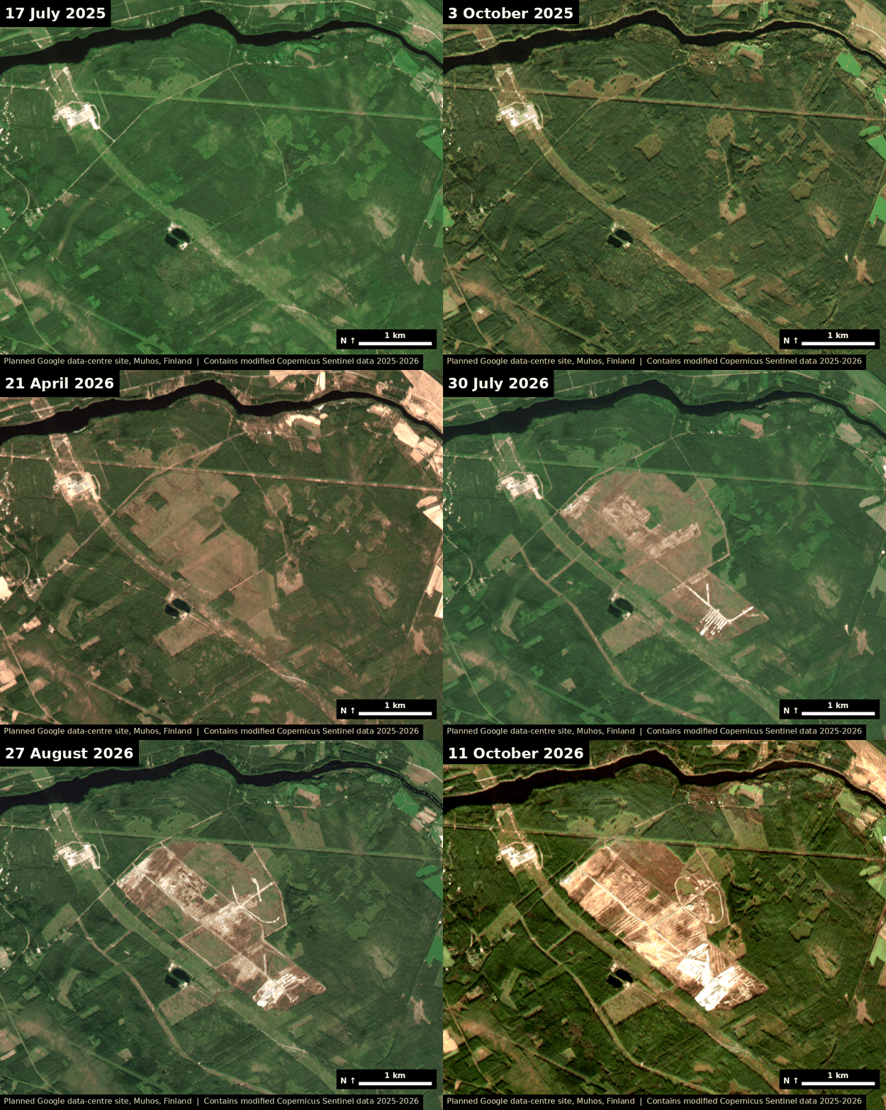
The Guardian recently reported that Google 'illegally' cut down over 250,000 trees across 330 hectares of forest for a new data centre in Finland, before the required environmental impact assessment was complete.
Since there was no accompanying satellite imagery with the piece, I decided to quickly use Claude to make me this gif that shows the scale of it – 330 hectares and 250,000 trees is hard for me to visualise.
The visual below clearly shows the Muhos site from July 2025 to October 2026: the forest is intact into autumn 2025 and cleared by early April 2026, followed by stripped soil and site roads.
Satellite imagery is free to use and AI makes this a 10-minute task (that’s what I did). So, I hope more media outlets start complementing stories with satellite visuals, as I think it is a lot more powerful.
Until next time,
Aravind.


