


Welcome to a new edition of Earth Observation Essentials, the free biweekly newsletter from TerraWatch covering key highlights from the EO market along with exclusive insights and analysis.
If you would like a more detailed, comprehensive market briefing with exclusive analysis, delivered every week, become a Pro subscriber, or a Premium subscriber, for more deep dives on EO markets, technologies and applications.
📈 EO Market Highlights
Major developments in EO
- Geospatial AI startup LGND launched a new tool that connects satellite and aerial imagery directly to AI assistants such as ChatGPT and Claude, letting users ask natural language queries to search, compare, classify and detect changes in satellite (Sentinel-2) and aerial (NAIP) imagery.
Related: If you would like to learn more about EO for AI including foundation models, embeddings and what that means for the market, check out our latest deep-dive (exclusively for Premium subscribers).
- Spanish EO startup Xoople and Belgian research organisation VITO signed a strategic partnership to build new EO solutions across the value chain from enhancing satellite data to translating data into insights.
- The WMO (World Meteorological Organization) and ITU (International Telecommunication Union) called for stronger protection of radio frequencies used by weather and EO systems, warning that growing interference could degrade satellite measurements, weather forecasts and early-warning services.
- Japan is planning to invest over $1.8B in EO satellites, data buys and downstream applications as per the proposed budget request for FY2027.
The $1.8B includes almost $1.2B for a new EO constellation, over $450M for commercial satellite data buys and $67M to improve EO adoption across as agriculture, environment and disaster management ministries.
In a recent edition of the Pro newsletter, I analysed how Japan is building an integrated public-private EO architecture and how EO is becoming invisible infrastructure, not simply a line item in the space budget.
Upgrade to a Pro subscription for just $75 per year to check out the analysis and receive weekly exclusive market briefings.
💡 Insight Bytes
A quick dose of analysis from TerraWatch
The following insight brief is part of the TerraWatch Pro newsletter and included here as a preview for free subscribers. To receive weekly exclusive insights and analysis, become a Pro subscriber at only $75 per year.
The Productization of Embeddings and What It Means for the EO Market
Back in July, Google announced the Private Preview of Custom Satellite Embeddings, a new data product that uses Google DeepMind’s AlphaEarth Foundations AI model.
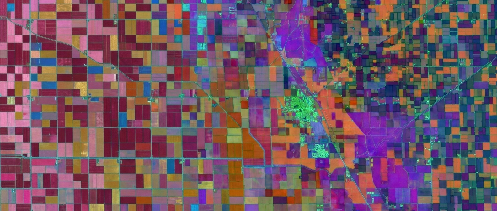
When Google first introduced AlphaEarth, it was mainly a research milestone: a deep learning foundation model that ingests multi-sensor data (optical, radar, LiDAR) to output a 64-dimensional vector (called an embedding) for every 10-meter pixel. The distribution was basically limited to static, annual global datasets hosted in Google Earth Engine (GEE), which is a product predominatly developed and used for academic and research purposes.
The announcement, though, changes the games in two fronts: productization and distribution.
- Productization (Annual snapshots → Continuous (every 5-day) monitoring): Google is moving from static mapping to near-real-time monitoring by allowing enterprise users to request custom areas of interest updated on 5-day cycles.
- Distribution (Academic sandbox → Managed data product): Instead of forcing users to navigate GEE or build heavy satellite pipelines, Google is distributing these pre-processed, ML-ready vectors directly through the commercial Google product suite (Maps, Cloud etc.).
By packaging change detection as an enterprise feature rather than raw pixels, Google is making AI-based EO analytics directly queryable inside tools like BigQuery and Vertex AI, used by large enterprises.
What This Means for EO Downstream Analytics Companies
For EO downstream companies, particularly those selling specialized feature extraction, land cover classification, or change detection, this is an existential change.
Historically, these startups justified their margins by taking care of the "boring" infrastructure layer: ingesting multispectral data from Sentinel or Landsat, performing atmospheric correction, stripping out cloud cover, and training computer vision models to track changes on the surface.
But Google’s Custom Satellite Embeddings product turn that entire processing pipeline into a change detection feature capable of delivering analytics instantaneously. Instead of a developer downloading gigabytes of imagery and building custom ML architectures, they can perform a similarity search directly inside BigQuery or Vertex AI. If an enterprise wants to flag vegetation growth near power lines or detect agricultural changes, they can easily do so with the pre-computed embeddings over a 5-day period.
What remains as differentiation for EO downstream companies is labelled ground truth, validation against field data, and accountability for the answer which are always the hardest to buy.
What This Means for EO Data Providers
For EO satellite data companies, this trend might be a double-edged sword.
On one hand, Google’s embeddings are built on public, medium-resolution sensors (primarily 10m Sentinel and Landsat data). For use cases requiring sub-meter resolution such as asset monitoring or property inspection, their differentiation remains and the value will always be there. Google’s 10m foundation model cannot replace a 30cm optical image or high-resolution SAR.
On the other hand, Google might be establishing a new standard for how enterprise customers consume EO data. The market is rapidly moving away from purchasing raw imagery tiles or paying for per-square-kilometer pixels. As Google normalizes the "embeddings-as-a-service" model, EO data companies will face some pressure to expose their own high-resolution, proprietary data directly as embedding data products rather than selling traditional image files – especially the years of archives which are sitting locked in the cloud today.
TL;DR: This new development from Google looks like what Clayton Christensen called a disruptive innovation – a cheaper product that could displace many existing players. I think embeddings could very well change how geospatial intelligence is delivered and consumed, subject to its actual performance.
By turning complex multi-sensor satellite data into a managed change monitoring service, Google is trying to establish a new commercial standard for EO monitoring.
Raw pixel processing and general-purpose analytics could become low-margin commodities. This means that the main moat in EO belongs exclusively to: those who own the final operational workflows with customer (or) hold proprietary high-resolution data (or) possess proprietary domain-specific models or training data.
🔍 Recommended Reads
Interesting links to check out
- This excellent piece that shows why different EO-based damage assessments can produce very different answers after the same disaster, depending on the sensor, methodology and definition of damage.
- This paper that summarises the results and findings from executing a geospatial foundation model onboard a satellite.
- The 2026 edition of the Geospatial Tech Radar, from geospatial services firm Element84 that tracks emerging technical trends and emerging tools.
🛰️ Scene from Space
One visual leveraging EO
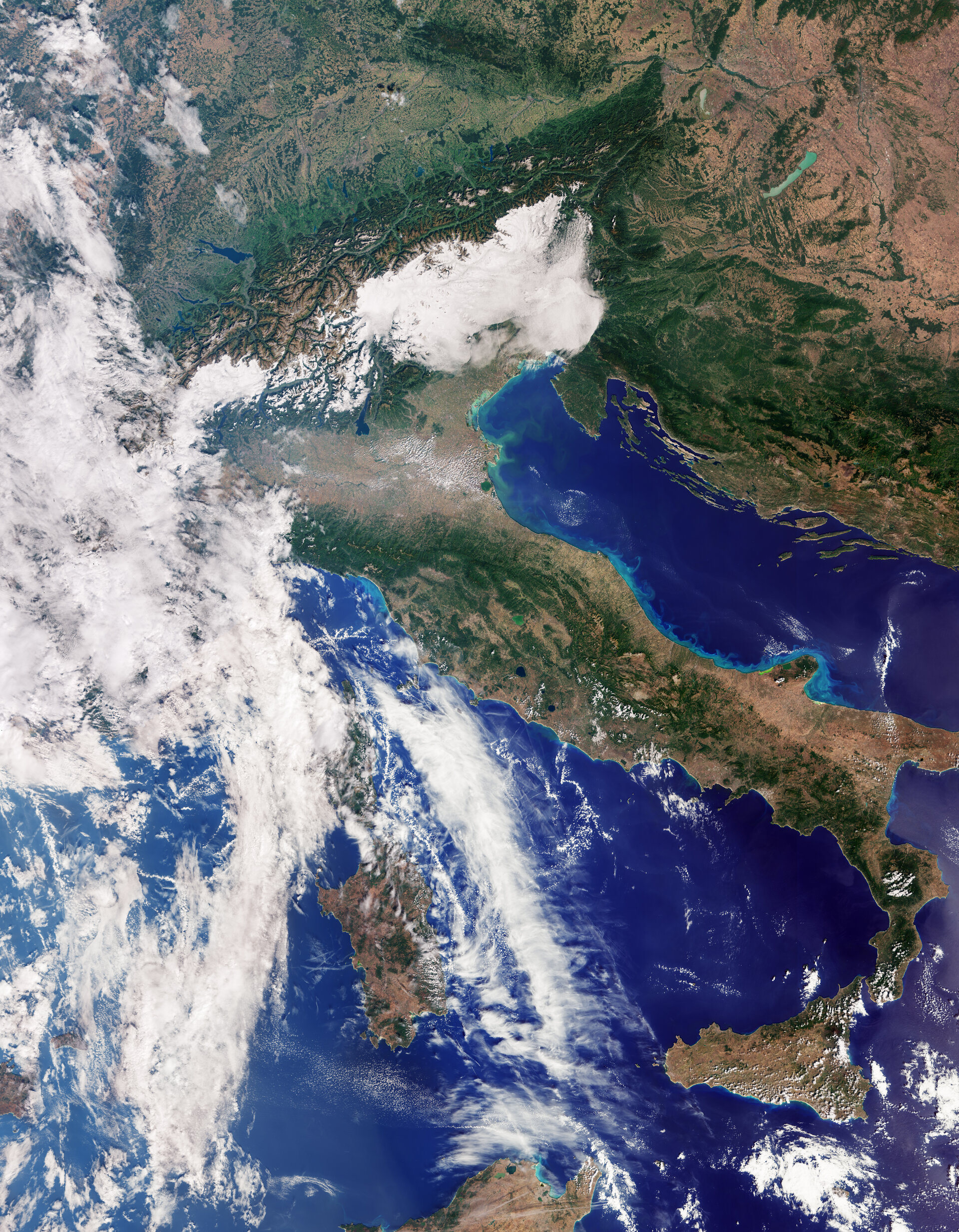
First Images from Sentinel-3C
Europe's Copernicus Sentinel-3C satellite has returned its first images after its launch a couple of weeks back. As the third satellite in the Sentinel-3 mission, it provides high-quality data on ocean and land surface temperatures, color, and topography to support climate and environmental monitoring.
Until next time,
Aravind.


