


Welcome to a new edition of Earth Observation Essentials, the free biweekly newsletter from TerraWatch covering key highlights from the EO market along with exclusive insights and analysis.
If you would like a more detailed, comprehensive market briefing with exclusive analysis, delivered every week, become a Pro subscriber, or a Premium subscriber, for more deep dives on EO markets, technologies and applications.
📈 EO Market Highlights
Major developments in EO
💸 EO satellite manufacturer Muon Space announced the closing of $250M in a Series C round, which brings the total funding raised to more than $386M.
💰 Starcloud, the startup building orbital data centers, has raised $250M extension to the $170M raised earlier this year, with the latest round including participation from Nvidia.
As launch dates slip, everything that earns Starcloud revenue before its first operational data center satellite flies remains the same as before: selling on-orbit processing services to EO companies and potentially defense / government customers. Yet, interestingly, EO seems to have disappeared from Starcloud's messaging at exactly the moment its dependence on EO has possibly deepened.
🚀 Satellite operators, including specifically EO companies, are concerned due to a worsening launch crisis as SpaceX looks towards winding down Falcon 9 launches for commercial customers, in favour of the bigger Starship rocket.
🌦️ NOAA awarded contracts to Spire Global ($3.7M) and PlanetiQ ($2.7M) to provide radio occultation data for terrestrial and space weather forecasts. This comes as the agency aims to create a new procurement mechanism that will allow data purchases up to $2.35B over 10 years.
According to our analysis, NOAA has awarded over $180M in contracts to weather satellite companies over the past decade. You would think the commercial weather market would be thriving and we will see a number of new companies pop up. That has been farther from the truth, due to the unique nature of how weather market operates.
In the TerraWatch Pro newsletter last week, I wrote about what makes the weather satellite market unique and how potentially this could become a real growing market opportunity.
Upgrade to a Pro subscription for just $75 per year to check out the analysis and receive weekly exclusive market briefings.
💡 Insight Bytes
A quick dose of analysis from TerraWatch
The following insight brief is part of the TerraWatch Pro newsletter and included here as a preview for free subscribers. To receive weekly exclusive insights and analysis, become a Pro subscriber at only $75 per year.
The Future of Landsat: From a Satellite to a Standard?
NASA and USGS will host an event – next week on August 31 – for EO companies intended to discuss and provide details on the commercialisation of the Landsat program. There is little information available at this point apart from a briefing document that came with the announcement, but it seems to give out a clear indication of what the Landsat program could look like and what the market should look like to help them inform on this decision.
Quick Primer on the State of Landsat
For anyone not following the program closely: Landsat Next was originally proposed to be three satellites, but budget pressure cut it to a single one, renamed Landsat 10 – now launching in 2031. The instrument will have 26 spectral bands including thermal with a 10m resolution.
The spacecraft draft RFP is already out, and USGS has said it will be built and operated the way past Landsat missions were. The proposed commercialisation plan sits alongside that mission, possibly in order to plan for the future after Landsat 10 launches.
What's Changing: 1) Moving from Procuring Products to Imagery
NASA and USGS want to buy three finished products in FY27: bathymetry, surface water extent, and burned area & burn severity with evapotranspiration to follow. Companies are expected to deliver the product according to the required specification. Today USGS makes these products itself from Landsat data, but under the new plan it will be EO companies that will develop them, using potentially whatever satellites and algorithms they choose.
In other words, the requirement becomes the product – meaning, any company with no satellites of its own can potentially be able to bid, while a satellite operator with no product line probably will not be able bid alone.
What's Changing: 2) Moving from Single Sensor to Multi-Sensor
The document released simply says that the product needs to meet the defined quality standards, while nothing in the document says it has to come from one satellite or one supplier.
In the past, Landsat products have always come from Landsat. But, in this new strategy shift, a company could could combine Sentinel-2, data from the company's own constellation and third-party data.
Simply owning a satellite may not be enough to win the contract. Making different sensors agree with each other and with a 54-year archive becomes the hard part, and that is a calibration problem rather than a hardware one. The document does not say whether the government inspects each input stream or only judges the final product, which decides how realistic a multi-source product is. This should hopefully be clarified in due course.
What's Changing: 3) Moving from Taking What the Market Gives to Making Sure a Market Exists
Previous commercial data buys by agencies were simply transactions – the agency would buy whatever data available it considers as a requirement. But, in this case, the government is keen on building the market with its role as a reliable, structured buyer, providing enough demand certainty to justify investment by the private sector.
That points away from a single Landsat supplier and towards work spread across several companies. It is important to emphasise again that all we have at this point is just a single document with no specific commitments, but we can infer the direction. But this are steps in the right direction in my opinion – more than what existed previously.
Is this enough commitment?
The government is asking companies to invest and develop the products now. But, all it has offered so far is is a demand signal, not a contract. Landsat 10 is still being built the conventional way, and the document says plainly that nothing is being solicited and that taking part confers no advantage in future procurement.
Whether commercial data can meet Landsat standards is an engineering question and probably solvable. Whether a signal – this soft – moves EO companies to move from their typically defense-centered strategy is the harder question, and probably worth watching in the coming years.
Although, one open question
The document released with the announcement says nothing about who owns the commercially generated product, or on what terms it can be redistributed. Landsat data is free because the government owns it, but a burn severity map made by a company is a different object.
Congress required open access and archiving of Landsat to be maintained, so for now, we need to assume that the principle is safe. The mechanics, I am certain, will be spelled out in the coming weeks and months, but whether the companies agree with it and are willing to adapt their typical closed (licensing-based) approach is the critical open question.
🔍 Recommended Reads
Interesting links to check out
- Analysis of satellite imagery showed how oil pollution is affecting waters near Iran, impacting coastal communities and ecosystems in the region.
- This paper that argues that AI finally bridging the long-standing divide between short-term weather prediction and long-term climate modeling, albeit with risks regarding model transparency and energy use.
- Satellite data from the Copernicus Sentinel-3 mission is reaching emergency services up to three times faster – from 180 mins to 60 mins – enabling a quicker response to wildfires in Europe.
🛰️ Scene from Space
One visual leveraging EO
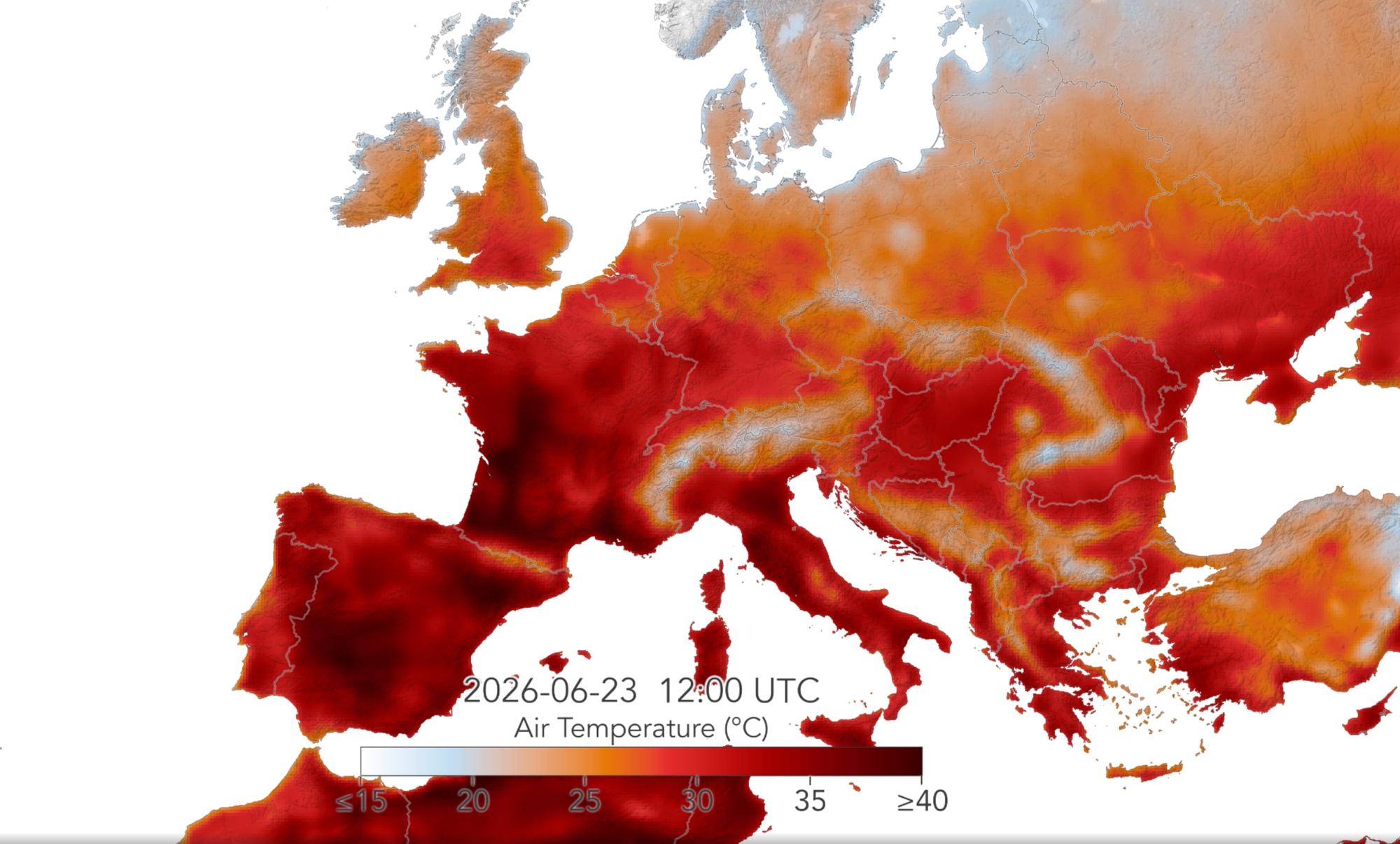
Visualising Europe's Sultry Summer 2026
Much of Europe just had its fifth heatwave of the year, an unusual phenomenon where summers have largely been mild in the past, perhaps with the occasional heatwave. Records fell as the continent recorded one of the hottest summers with the highest ever global ocean surface temperatures, with the developing El Niño also contributing.
The image below from NASA shows the maximum surface air temperature across Western Europe on the 23rd of June – you can find a visualisation of this for the entire summer here.
Until next time,
Aravind.


